- Home
- Snow Information
- National Analyses
- Interactive Maps
- 3D Visualization
- Airborne Surveys
- Snowfall Analysis
- Satellite Products
- Forecasts
- Data Archive
- SHEF Products
- Science/Technology
- NOHRSC
- GIS Data Sets
- Special Purpose Imagery
- About The NOHRSC
- Staff
- NOAA Links
- Snow Climatology
- Related Links
- Help
- Help and FAQ
- Site Map
- Contact Us
- Please Send Us Comments!

|
NOHRSC Help Page
-
-
- How do I zoom in?
- Either click on the plus icon next to the "Zoom Control" slider bar to zoom in by a factor of two, or
- Click to the right of the slider on the slider bar to possibly zoom in further. Each notch on the slider bar is considered a factor of two.

or

- Alternately, if you have javascript enabled, you may click and drag on the map to create a rectangle.
As soon as you release the mouse button, the map should zoom to the rectangle extents.
- This can be done at any time on the smaller index map, or on the larger main map when the "Recenter" button has been selected.
- Why doesn't a station I'm looking for appear on the map?
- Stations are progressively disclosed.
- The further you zoom in, the more stations are displayed.
- If the station you are looking for is not in our database or has not reported for an extended period of time, it may not be displayed at all.
- Why do more stations appear when I zoom in on a location?
- Stations are progressively disclosed.
- The further you zoom in, the more stations are displayed.
- This is done to give access to as many stations as possible while limiting the clutter in the map.
- Is there a point where the number of stations will quit increasing as I zoom in?
- Yes, once all reporting stations from our database are displayed.
- This happens once the user reaches an area 64km x 64km (103mi x 103mi) on the map.
- How do I zoom out?
- Either click on the minus icon next to the "Zoom Control" slider bar to zoom out by a factor of two, or
- Click to the left of the slider on the slider bar to possibly zoom out further. Each notch on the slider bar is considered a factor of two.

or

- How do I recenter the screen on a different point on the map?
- Click on the "Recenter" button (indicated by a set of crosshairs) above the map.
- Click on the position in the map where you would like to center the map.
- If you wish to recenter on a place that is not visible in the main map area, you may click on a spot in the smaller index map.

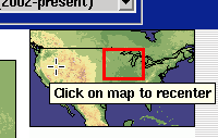
- What does the inlay map of the US in the upper right hand corner do?
- The index map allows you to see where the map display is located.
- If you click inside of the inlay map, the map display will recenter to that location.
- What if I have javascript turned off? Is there still a way to determine the latitude and longitude of my cursor? Is there still a way to zoom by rectangle?
- There are three disadvantages of having javascript disabled:
- With javascript turned off, you will not be able to determine the latitude and longitude of your cursor position.
- With javascript turned off, you will not be able to click and drag on the map in order to zoom by rectangle. Zooming by recentering the map and using the Zoom Control slider still works.
- With javascript turned off, you will have to click "Redraw Map" if you change between querying different features (otherwise it is automatic).
- That said, if you wish to use the Interactive Snow Information page with javascript disabled, toggle the "Javascript is on" button in the bottom left of the screen (you may have to scroll down). The screen will refresh and the button will change to "Javascript is off".

- How can I make a bookmark for a map that always shows the most current date?
- The date information is stored within the URL of the interactive map page (as well as in the "link to image" image URL). If the date is not specified, the page will default to the most recent date.
- So, to do this, you should remove the string "&dy=YYYY......dh=HH", which specifies the year, month, day, and hour, from the URL. After doing so, you should have a bookmark to a page (or image) that shows the most recent date.
-
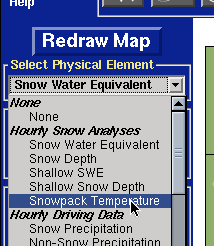
- How do I change the physical element that is displayed? (i.e. How do I see how much it snowed yesterday?)
- Under the heading Select Physical Element, you select what you want to see from the drop down box.
- Click "Redraw map" button.
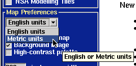
- How do I change from English units to metric units?
- Use the dropdown menu located in the Map Preferences window.
- Click "Redraw Map" button.
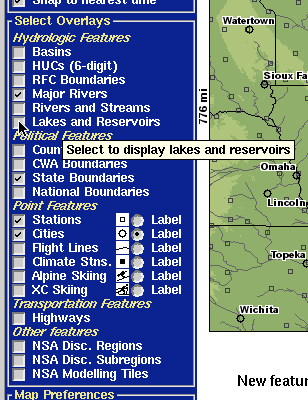
- How do I add roads, counties, etc. to the map?
- Select layers you want displayed by clicking in the box to the left of the layer name under the Select Overlays heading.
- Click "Redraw Map" button.
- How do I change the size of the map?
- Change the number to the left of the "pixels map width" and "pixels map height" in the "Map Preferences" section in the lower left corner of the screen (you may need to scroll down)
- Click "Redraw Map" button.

- Is it possible to save my preferences?
- Yes. Bookmarking the page you are at will record all preferences on the screen since all parameters are stored in the web page URL. We had previously used persistent cookies to record this information, but due to privacy issues, this is no longer possible. Session cookies are still available to use, which allow better communication between the date set on the interactive map page and the time series and text product page.
- If you wish to use session cookies, you can click on the "Cookie use is off" button in the "Map Preferences" section in the lower left of the screen (you may have to scroll down).
- If you would like to turn cookies off, click on the "Cookie use is on" button in the same location.

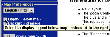
- What does the "Legend below map" option do?
- This option determines legend and index map placement. The default is to place both of those along the righthand side of the main map area. If checked, the index map and legend will be placed below the main map area. This may make more sense for users who choose a wider, more rectangular screen.
- It is hard to pick out the different colors on the snow depth and SWE maps. How can I make the colors more visible?
- Check the box next to the "High-contrast palette" preference, and click "Redraw Map". For the various snow depth and snow water equivalent physical element types, this will display a much bolder color palette. This has no effect on the other physical elements.
- This will automatically turn off the background image.

- I've selected the labels for the flight lines, but they do not display. Where are the labels for the flight lines?
- Unlike regular stations which are progressively disclosed, all flight lines are always displayed no matter how far in or out you might be. Though this creates some clutter, it better indicates the spatial extents of the NOHRSC flight lines. However, the total of the flight line labels when zoomed out is completely unreadable, so the labels are only shown after zooming in past a certain threshold.
- I want to view the Interpolated Total Snowfall physical element without the clutter of the value labels. How do I do that?
- Check the box next to the "Hide observation values" preference, and click "Redraw Map". This removes the numerical value overlay from the Interpolated Total Snowfall maps. This also has the effect of removing the numerical value overlay from all the other Latest Observations physical elements.
-
- How do I view a time series plot for a given station?
- Make sure that the station to be queried can be seen. (see zooming and adding overlays)
- Click the Query information icon button.
- Select "Station (2002-present)" underneath the Time Series subheading next to the Query information button.
- (During these two steps, the screen will refresh- loading the imagemap that will allow the station to be selected)
- Move the cursor over the station and click. A new window will load containing the time series plots.
- (If your browser supports tabs, it is often convenient to load the resulting page in a new tab.)

- How do I view a time series plot for a given basin?
- Make sure that the basin to be queried can be seen. (see zooming and adding overlays)
- Click the Query information icon button.
- Select "Basin" underneath the Time Series subheading next to the Query information button.
- (During these two steps, the screen will refresh- loading the imagemap that will allow the basin to be selected)
- Move the cursor over the basin and click. A new window will load containing the time series plot.
- (If your browser supports tabs, it is often convenient to load the resulting page in a new tab.)

- How do I view all basin average values within a certain region (for example, a county warning area)?
- Make sure that the polygon layer overlay that contains the region in question to be queried can be seen. (see zooming and adding overlays)
- Click the Query information icon button.
- Select "Basins by {region type}" underneath the Basin averages by region subheading next to the Query information button.
- (During these two steps, the screen will refresh- loading the imagemap that will allow the region to be selected.)
- Move the cursor over the region and click. A new window will load containing the text product.
- (If your browser supports tabs, it is often convenient to load the resulting page in a new tab.)

- How do I compare current snow depth reports with historical depth observations?
- To display the subset of stations that have snow depth climatology, select the "Climate Stns." overlay, and then "Redraw Map". They will appear as filled-in squares. Then,
- Click the Query information icon button.
- Select "Station (Climatology)" underneath the Time Series subheading next to the Query information button.
- (During these two steps, the screen will refresh- loading the imagemap that will allow the stations to be selected.)
- Move the cursor over a station and click. A new window will load with the climatology page.
- (If your browser supports tabs, it is often convenient to load the resulting page in a new tab.)

- How do I view time series for a list of stations when I don't want to graphically select each one?
- Go to the upper righthand corner of the page and use the Quick Query Links
- If you know the SHEF ID of the station in question, enter it into the input box next to "Get Time Series for Station ID:", and then click "Go".
- If you do not know the SHEF ID of the observation station, you can browse a listing organized by Weather Forecasting Office by following the "Listing" link to the right.

- How do I view time series for a list of basins when I don't want to graphically select each one?
- Go to the upper righthand corner of the page and use the Quick Query Links
- If you know the SHEF ID of the basin in question, enter it into the input box next to "Get Time Series for Basin ID:", select the corresponding River Forecast Center, and then click "Go".
- If you do not know the SHEF ID of the basin, you can browse a listing of basins in each RFC by: leaving the basin field blank, selecting a RFC, and then click "Listing".

- How do I view basin average text products for a list of counties when I don't want to graphically select each one?
- Go to the upper righthand corner of the page and use the Quick Query Links
- If you know the name of the region in question, enter it into the input box next to "Get Basin Averages for", select the corresponding region type, and then click "Go".
- If you do not know the exact name of the region, you can browse a listing of region names by type by: leaving the name field blank, selecting a type, and then clicking "Listing".

- How do I view current and historical snow depth climatology for a station when I don't want to graphically select each one?
- Go to the upper righthand corner of the page and use the Quick Query Links
- If you know the SHEF ID of the station in question, enter it into the input box next to "Get Climatology for Station ID:", and then click "Go".
- If you do not know the SHEF ID of the observation station, you can browse a listing organized by Weather Forecasting Office by following the "Listing" link to the right.
- Note that these are a listing of the superset of observation stations, not just those that report climatology.

- How do I determine what stations reported what on the Latest Observations maps (like snowfall, etc..)?
- Display the Latest Observation physical element of your choice with the appropriate date
- Select Query -> Latest Observations from the Query dialog, and click the Query button
- The screen should refresh, and now mousing over (or clicking) on the map values should show some information (or a link to information) on that station.
-
- What are the National Snow Analyses (NSA)?
- The NOHRSC National Snow Analyses (NSA) provide daily comprehensive snow information for the coterminous United States. The NSA are based on modeled snow pack characteristics that are updated each day using all operationally available ground, airborne, and satellite observations of snow water equivalent, snow depth, and snow cover. The NOHRSC snow model is a multi-layer, physically based snow model operated at 1 km� spatial resolution and hourly temporal resolution for the nation. Snow data used to update the model include observations from the NOHRSC's Airborne Snow Survey Program, NWS and FAA field offices, NWS Cooperative Observers, the NRCS SNOTEL and snow course networks, the California Department of Water Resources snow pillow networks, and snow cover observations from NOAA's GOES and AVHRR satellites.
- What are the products formats for the National Snow Analyses (NSA)?
- NSA product formats include daily regional maps and text summaries, and a suite of interactive map, text, and time series products. The NSA include information about snow water equivalent, snow depth, snow temperature, snow melt, snow pack sublimation, sublimation from blowing snow, snow surface energy exchanges, precipitation, and weather.
- What are the time periods for the products for the National and Regional Snow Analyses?
- The national snow water equivalent map is a product from the NOHRSC Snow Model (NSM) at 0600 UTC (midnight Central Standard Time).
- The change in snow water equivalent map is a product fom the NSM created at 0600 UTC (midnight CST) by computing the change of snow water equivalent from the previous 24-hour period.
- The snow depth product derived from the NSM at 0600 UTC (midnight CST).
- The hourly snowpack temperatures for the latest 24-hour period ending at 0600 UTC (midnight CST) are averaged for the national and regional snowpack temperatures.
- The national snow precipitation is an input into the NSM. This map shows the total precipitation that occurred as snowfall over the 24-hour period ending at 0600 UTC (midnight CST).
- Non-snow precipitation is an input into the NSM. This map shows the total precipitation that occurred as snowfall over the 24-hour period ending at 0600 UTC (midnight CST).
- The national snow melt is simulated by the NSM showing the total snow melt over the 24-hour period ending at 0600 UTC (midnight CST).
- The national surface sublimation and blowing snow sublimation is simulated by the NSM showng the total total sublimation or condensation from the top of the snowpack over the 24-hour period ending at 0600 UTC (midnight CST).
- Are there any products produced for Alaska?
- A satellite snow cover product is produced for Alaska and can be seen on the interactive website by choosing the physical element "Snow Cover (Alaska)" under the Daily Satellite Obs. subheading.
- Click the Alaska Extents button to reposition the map on Alaska.
- The NOHRSC also occasionally flies airborne gamma snow surveys over Alaska, and generates maps and airborne gammma SHEF messages from those results. More information can be found on the Airborne Snow Survey page.

- What is a SHEF message and what SHEF products are produced by NOHRSC?
- A SHEF message follows the standard format used by NWS to distribute forecasted and point data for use in hydrologic operations. This is called the Standard Hydrometeorological Exchange Format (SHEF).
- The NOHRSC produces 2 SHEF products for the 13 River Forecast Centers across the United States daily.
- These products are snow water equivalent derived by the the NSM and snow cover by RFC.
- A SHEF message is also created by NOHRSC when a airborne snow survey is conducted. For more information about the airborne SHEF message please see key to airborne SHEF messages.
- Where are the average temperatures, freezing degree days, and thawing degree days products now located?
- These products are now located on the interactive website as a choice under the physical elements pull down menu.
- How are the automated model discussions created?
- The automated model discussions are created daily by averaging the modeled snowdepth and snow water equivalent over a region.
- How can I embed a NSA animation on my web site?
- What is the projection and horizontal datum used in the maps?
- The maps use a geographic latitude-longitude "projection". The horizontal datum used is WGS 84.
-
-
- How can data from NOHRSC be obtained?
- I'm looking for snowfall or snowdepth in my town, but I can't find it on your site. What do I do?
There are several sites that have snowfall information besides ours.
- Your local NWS Forecast Offices has the best snowfall information.
In addition to the airport weather observers and co-op sites,
they accumulate all the reports from people who phone in depths
into their Public Information Statements.
After a big storm like last week's, they will often make
a summary page.
- The National Climate Data Center is the place to go for
"official" data, but it may be several days before all
the data is posted. They will have a
map of snowfall for the
previous 3 days:
- In states west of Colorado, the
Natural Resources Conservation Service operates a network of automated Snow
monitoring stations (SNOTEL). They publish their work
here.
- Your local TV station's website might have recent snowfall
information. They usually contract with one of the big
national firms that specialize in weather graphics.
Different stations might subscribe to different services,
so check around.
There are three main kinds of weather observers:
Co-op stations send daily reports directly to the NWS -- they monitor
airports, agricultural stations and such; Amateur observers who
subscribe through the CoCoRaHS network (the Community Cooperative
Rain, Snow & Hail network); and ordinary folks who pick
up a phone and send reports to the NWS during a storm.
- CoCoRaHS has a
daily map of their reports.
You can zoom in on a particular state.
- The local NWS FO posts the phone-in reports on their
Public Information Statement page.
- NOHRSC posts all the snow observations it receives
from co-op sites, MADIS, SNOTEL, CoCoRaHS and the other
observational weather data networks.
If you are lucky, there is an observer near your region
of interest in one of those lists mentioned above.
NOHRSC has a Observation Finder button on their front page.
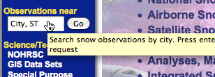
Type in, for example, "SPRINGFIELD, NJ" and see nearby values for
Raw Snowfall, Snow Depth and Snow Water Equivalent (SWE).
https://www.nohrsc.noaa.gov/nearest/index.html?city=Springfield,NJ&county=Union
- What is the difference between your Raw Snowfall and Depth? Which is the accurate accumulation I should be using to find out how many inches fell in a storm?
Tim's response:
"I've got a CoCoRaHS rain gauge and snowboard in my back yard.
In the winter, I go out at 7am for a measurement. I stab my
yardstick straight down into the snowpack to get the Depth.
I measure the depth of any new snow fallen on the snowboard;
that is the Raw Snowfall. Then I scrape off the previous day's
accumulation, to start fresh for tomorrow.
The snow fallen in the rain gauge gets dumped into a pyrex bowl,
to be melted and measured. This is the Raw Precip Observation,
the quantity of Liquid Water contained in the previous day's snowfall.
The final measurement is the SWE, the snow water equivalent
contained in the snowpack. I thrust the rain gauge straight down
into the snowbank, slip a spatula under the opening and lift it to
the surface. The contents are dumped into another bowl, to be
microwaved and melted. The SWE is the primary statistic we
model at NOHRSC.
So, the Raw Snowfall is a measurement of snow fallen since the
last reading. It is a rate, rather than an amount. Many are taken daily,
but some airports and NWS offices check it in six or twelve hour
intervals. Snowstorms don't always fall into neat 7am-7am
timeframes. We often have to split a single event into, say,
midnight to 7am, sent today, and 7am-10am, reported the next day.
Check other nearby sites in the 'Observations Near' list for
overall agreement. Other sources are https://www.cocorahs.org,
https://gis.ncdc.noaa.gov/maps/snowfall.map?view=daily, and
https://www.srh.noaa.gov/ridge2/snow.
Your local NWS Forecast Office usually issues all the station
measurements, as well as one-time reports from police and Skywarn
spotters that get radio'd in, along with amounts from the public
posted to their NWSFO websites.
On the NOHRSC front page, follow the 'Organization' link at the top
to locate the NWSFO that serves your area. Many have summary
pages that post reports as they come in and final tallies after
the event."
Glossary
Observations
- Observed "Raw" Precipitation
- This is the amount of water in whatever form that has fallen over a specified duration
(1 hour, 6 hours, 24 hours, etc...).
- Observed "Raw" Snowfall
- This is the vertical measurement of snow that has fallen over a specified duration
(1 hour, 6 hours, 24 hours, etc...).
- Observed Snow Density
- This the density of the snow that is on the ground. This is derived from dividing the
observed snow water equivalent by the observed snow depth. This can be likened to the
perceived "heaviness" of the snow. Higher numbers mean more packed snow, while lower numbers
correspond to lighter powdery snow.
- Observed Snow Depth
- This is the measured height of snow that is on the ground.
- Observed Snow Water Equivalent
- This is how much water would be measured if the snow on the ground was completely melted.
This can also be calculated by taking a vertical core of snow from the ground, weighing it,
and converting that to height using the density of water.
- Observed Total Precipitation
- This is derived from taking the observed raw precipitation and divvying it into
one hour increments. This is then temporally shifted by the presence (or lack of presence)
of Stage 2 RADAR only precipitation.
(Example: a station reports that an inch of water fell
over a six hour period. Radar data measured precipitation only in two of those six hours.
The inch of precipitation is then weighted between those two hours. No precipitation is assigned
to the other four hours.)
A precipitation total for an arbitrary duration is then summed from these derived one hour
increments.
- Observed Total Snowfall
- This is derived from taking the observed raw snowfall and divvying it into
one hour increments. This is then temporally shifted by the presence (or lack of presence)
of Stage 2 RADAR only precipitation.
(Example: a station reports that an inch of snow fell
over a six hour period. Radar data measured precipitation only in two of those six hours.
The inch of snow is then weighted between those two hours. No precipitation is assigned
to the other four hours.)
A snowfall total for an arbitrary duration is then summed from these derived one hour
increments.
Changes for the 2011-2012 season:
Interactive Map Changes
- Expanding the modeled geospatial domain further into Canada to include
the Great Lakes drainage area, and
- Executing the model in a 72 hour forecast mode where the first 18
forecast hours are forced by output from the Rapid Refresh (RR) model
and the remaining 54 hours are forced by output from the North
American Mesoscale (NAM) model.
|

