National Weather Service United States Department of Commerce


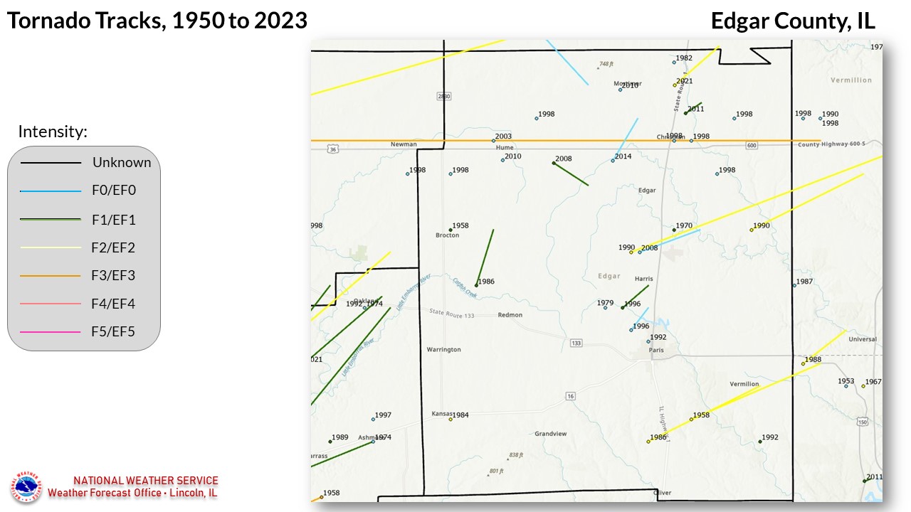
Edgar County tornadoes since 1950


30 TORNADOES were reported in Edgar County, Illinois between 01/01/1950 and 12/31/2023.

Click on Location or County to display Details.

Mag:
Dth:
Inj:
PrD:
CrD:
Magnitude
Deaths
Injuries
Property Damage
Crop Damage
 
Location or County Date Time (CST) Mag Dth Inj PrD CrD
1 EDGAR 05/03/1958 05:30 PM F2 0 0 0K 0
Brocton 06/13/1958 04:30 PM F1 0 0 25K 0
Hume 04/22/1963 06:55 PM F3 0 20 25K 0
Chrisman 05/24/1970 07:45 PM F1 0 0 3K 0
5 EDGAR 06/22/1979 02:27 PM UNK  0 0 0K 0
Chrisman 07/07/1982 12:15 PM F0 0 0 0K 0
Kansas 05/25/1984 06:40 PM F2 0 0 250K 0
Isabel 05/15/1986 07:04 PM F1 0 0 25K 0
Paris 05/15/1986 07:30 PM F2 0 0 0K 0
10 Hume 06/13/1987 02:28 PM F0 0 0 0K 0
11 Grandview 06/02/1990 04:30 PM F1 0 0 25K 0
12 Horace 06/02/1990 04:53 PM F2 0 0 25K 0
13 St. Bernice (IN) 06/02/1990 04:58 PM F1 0 0 0K 0
14 Paris 07/30/1992 12:25 PM F0 0 0 25K 0
15 Paris 04/19/1996 04:10 PM F1 0 0 N/A  0
16 Paris 04/19/1996 04:12 PM F0 0 0 N/A  0
17 Brocton 04/07/1998 07:11 PM F0 0 0 N/A 0
18 Chrisman 04/07/1998 07:15 PM F0 0 0 N/A 0
19 Hume 04/07/1998 07:29 PM F0 0 0 0 0
20 Scottland 04/07/1998 07:49 PM F0 0 0 N/A 0
21 Chrisman 05/19/1998 06:30 PM F0 0 0 0 0
22 Chrisman 05/19/1998 06:30 PM F0 0 0 0 0
23 Hume 04/04/2003 06:35 PM F0 0 0 0 0
24 Horace 07/08/2008 05:45 PM EF0 0 0 60K 0
25 Metcalf 07/21/2008 09:34 PM EF1 0 0 85K 0
26 Hume 05/21/2010 11:20 AM EF0 0 0 0 0
27 Metcalf 05/21/2010 11:40 AM EF0 0 0 0 0
28 Chrisman 04/19/2011 06:59 PM EF1 0 0 140K 0
29 Chrisman 02/20/2014 05:43 PM EF0 0 0 0 0
30 Chrisman 12/10/2021 10:41 PM EF2 0 0 N/A 0
TOTALS: 0 20 688K 0


Details:

  1. 5/3/1958:  This tornado touched down in Vigo County, Indiana, and moved north-northwest before lifting in southeast Edgar County.  The peak intensity was F2 on the Indiana side of the line. 
  2. 6/13/1958:  Touched down near Brocton, affecting one farm.
  3. 4/22/1963:  This tornado originally touched down just east of Tuscola (Douglas County).  It roughly paralleled U.S. route 36 across Edgar County before lifting 1 mile east of the Indiana border.  Total length was approximately 42 miles.
  4. 5/24/1970:  Brief touchdown 1 mile south of Chrisman, overturning a trailer.
  5. 6/22/1979:  Information is unavailable about this storm.
  6. 7/7/1982:  Touched down in extreme northeast Edgar County, 1 mile south of the Vermilion County line near the Woodyard rail station.  It was on the ground for 3 minutes, but caused no damage.
  7. 5/25/1984:  Touched down in Kansas, damaging several structures including the high school gymnasium roof.
  8. 5/15/1986:  Moved across the east and southeast portions of Isabel during its 3.5 mile path.  Damaged several buildings in town, and several farms northeast of town.
  9. 5/15/1986:  Touched down 5 miles south of Paris, and moved northeast for 5 miles.  Destroyed one farm along highway 1, and damaged several other farms just east of Vermillion.
  10. 6/13/1987:  This tornado touched down near Allerton in southern Vermilion County, and moved southeast into far northwest Edgar County near Palermo (5 miles north of Hume).  It caused no damage.
  11. 6/2/1990:  Touched down near Grandview, and traveled for 8 miles.  Four buildings lost their roofs at Grandview, and two other homes were damaged near highway 1.
  12. 6/2/1990: This tornado first touched down 1 mile southwest of Horace, then was aloft over town before beginning a continuous path on the ground.  A farm was destroyed east of Horace.  The tornado was on the ground for about 11 miles in Illinois, and 8 in Indiana. 
  13. 6/2/1990:   Touched down 8 miles northeast of Paris, and moved northeast across the state line to St. Bernice, IN.  It was on the ground for 4 miles in Illinois.
  14. 7/30/1992:  Brief touchdown just north of Paris, destroying a shed at a farm.
  15. 4/19/1996:  Touched down 3 miles northwest of Paris, and was on the ground for 2 miles.  It damaged 6 farms.
  16. 4/19/1996:  Touched down 1.5 miles northwest of Paris, and was intermittantly on the ground for 1 mile.  It mainly damaged trees and outbuildings.
  17. 4/7/1998: Touched down 4 miles north of Brocton, destroying a shed and 7 utility poles.
  18. 4/7/1998:  Brief touchdown near Chrisman, causing minor damage on the west side of town.
  19. 4/7/1998:  Brief touchdown 2 miles northeast of Hume, causing no damage.
  20. 4/7/1998:  Touched down 1 mile north of Scottland, causing minor damage.
  21. 5/19/1998: Brief touchdown 1 mile east of Chrisman, causing no damage.
  22. 5/19/1998:  Brief touchdown 4 miles southeast of Chrisman, causing no damage.
  23. 4/4/2003: Brief touchdown in an open field, causing no damage.
  24. 7/8/2008:  Touched down 2 miles south-southwest of Horace, and moved northeast for 4 miles, damaging several pole barns and grain bins.
  25. 7/21/2008:  Touched down 2 miles southwest of Metcalf, then moved northeast for 2 miles, damaging two homes and several outbuildings.
  26. 5/21/2010:  Brief touchdown 1 mile south of Hume, causing no damage.
  27. 5/21/2010:  Brief touchdown northeast of Metcalf, causing no damage.
  28. 04/19/2011:  Touched down 1.7 miles northeast of Chrisman, tearing the roof a house, destroying two pole barnes, and damaging a garage.  Was on the ground for just over a mile.
  29. 02/20/2014:  Touched down 3.9 miles west-southwest of Chrisman, crossing US-36 before lifting after a path of 3 miles. No damage was reported.
  30. 12/10/2021:  This strong tornado touched down 3 miles north of Chrisman. Click here for more details. 
pFad - Phonifier reborn

Pfad - The Proxy pFad of © 2024 Garber Painting. All rights reserved.

Note: This service is not intended for secure transactions such as banking, social media, email, or purchasing. Use at your own risk. We assume no liability whatsoever for broken pages.


Alternative Proxies:

Alternative Proxy

pFad Proxy

pFad v3 Proxy

pFad v4 Proxy