National Weather Service United States Department of Commerce


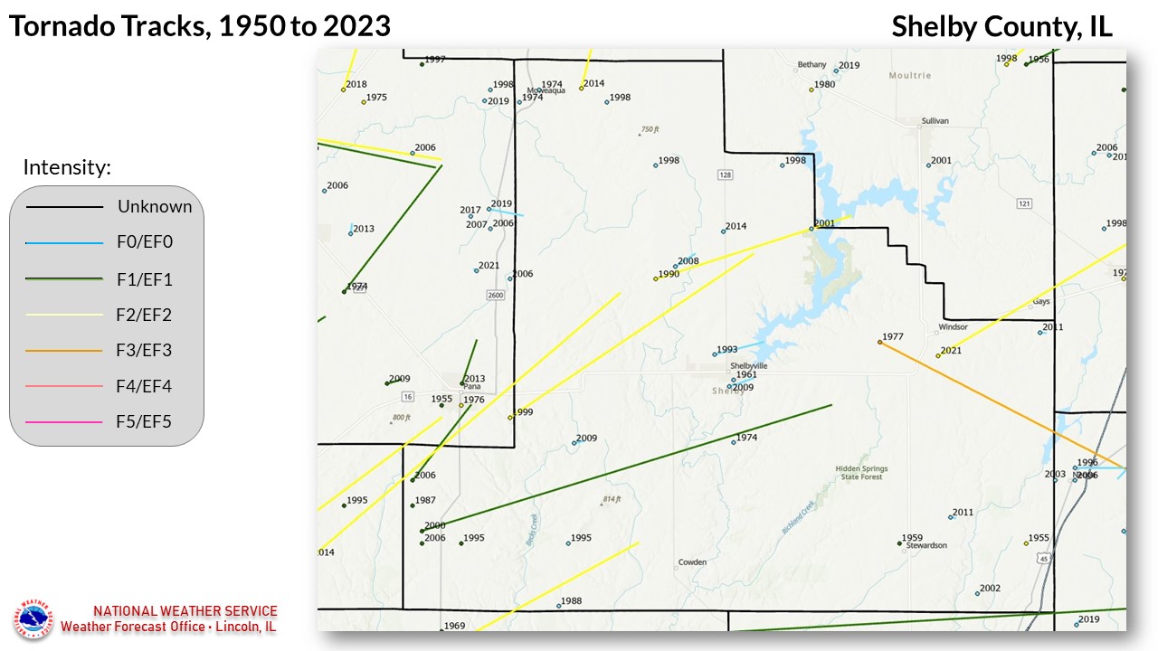
Shelby County tornadoes since 1950


33 TORNADOES were reported in Shelby County, Illinois between 01/01/1950 and 12/31/2023.

Click on Location or County to display Details.

Mag:
Dth:
Inj:
PrD:
CrD:
Magnitude
Deaths
Injuries
Property Damage
Crop Damage
 
Location or County Date Time (CST) Mag Dth Inj PrD CrD
Sigel 10/06/1955 07:00 PM F2 0 0 3K 0
Stewardson 03/26/1959 12:40 AM F1 0 0 0K 0
Sigel 03/06/1961 02:35 AM F1 0 1 250K 0
Shelbyville 07/28/1961 03:30 PM F0 0 0 25K 0
Oconee 06/24/1969 01:25 PM F1 0 0 3K 0
Shelbyville 06/22/1974 02:04 PM F0 0 0 0K 0
Moweaqua 08/10/1974 04:00 PM F0 0 0 N/A N/A 
Windsor 08/21/1977 Noon F3 0 0 N/A 0
Herrick 04/22/1988 06:04 PM F0 0 0 25K 0
10 Westervelt 06/02/1990 03:30 PM F2 0 2 2.5M N/A
11 Oconee 05/09/1995 06:56 PM F1 0 0 N/A 0
12 Cold Spring 05/09/1995 07:30 PM F0 0 0 N/A 0
13 Moweaqua 04/07/1998 05:28 PM F0 0 0 0 0
14 Findlay 04/07/1998 05:40 PM F0 0 0 0 0
15 Yantisville 04/30/1998 03:30 PM F0 0 0 0 0
16 Tower Hill 06/01/1999 07:06 PM F2 0 4 2.0M N/A
17 Oconee 06/20/2000 01:32 PM F1 0 1 75K 0
18 Findlay 07/08/2001 04:14 PM F0 0 0 0 0
19 Sigel 05/01/2002 03:20 PM F0 0 0 0 0
20 Oconee 01/02/2006 08:02 AM F1 0 0 15K 0
21 Oconee 04/02/2006 05:14 PM F1 0 0 0 0
22 Westervelt 05/30/2008 07:33 PM EF0 0 0 0 0
23 Tower Hill 05/13/2009 11:12 PM EF0 0 0 60K 0
24 Shelbyville 05/13/2009 11:22 PM EF0 0 0 45K 0
25 Windsor 06/15/2011 02:25 PM EF0 0 0 0 0
26 Stewardson 06/15/2011 02:30 PM EF0 0 0 20K 0
27 Oconee 02/20/2014 04:14 PM EF0 0 0 20K 0
28 Dollville 02/20/2014 04:25 PM EF2 0 1 80K 0
29 Findlay 02/20/2014 04:40 PM EF0 0 0 0 0
30 Moweaqua 10/13/2014 02:54 PM EF2 0 0 235K 0
31 Moweaqua 08/12/2019 08:43 PM EF0 0 0 0 100K
32 Herrick 12/10/2021 08:53 PM EF2 0 1 N/A 0
33 Windsor 12/10/2021 09:50 PM EF2 0 0 N/A 0
TOTALS:   1 10 7.86M N/A


Details:

  1. 10/6/1955:  Destroyed farm buildings on 3 farms, 3 miles north of Sigel.
  2. 3/26/1959:  Brief touchdown in Stewardson.
  3. 3/6/1961:  Brief touchdown at Sigel, where a house was twisted off its foundation.  The thunderstorm causing this tornado caused intermittent tornado touchdowns in several locations along a 120 mile path, from Jerseyville to Greenup.
  4. 7/28/1961:  A small tornado toppled 19 trees and damaged several buildings on a farm near Shelbyville.
  5. 6/24/1969:  Brief touchdown along the Shelby/Fayette County line south of Oconee.
  6. 6/22/1974:  Touched down 4 miles south of Shelbyville.
  7. 8/10/1974:  Followed an intermittent 1 mile path across Moweaqua, causing minor damage to a cemetery.
  8. 8/21/1977:  This tornado touched down 2 miles west of Windsor, then traveled southeast into Cumberland County near Lake Mattoon.  The fatalities and worst damage occurred at Lake Mattoon, on the Cumberland County side of the lake. 
  9. 4/22/1988:  Tore the roof off a cafe in Herrick.  Tornado traveled 1/2 mile, and was accompanied by 2 inch diameter hail.
  10. 6/2/1990:  Touched down just west of Westervelt, and after lifting briefly, touched down again before moving across western and northern parts of Findlay, ending near Lake Shelbyville.  16 homes were destroyed, and 60 damaged.
  11. 5/9/1995:  Brief touchdown 2 miles southeast of Oconee, destroying 2 mobile homes and several outbuildings.
  12. 5/9/1995:  Touched down 2 miles east of Cold Spring, and was on the ground for 1 mile.  It destroyed 3 large barns and damaged several homes.
  13. 4/7/1998:  Brief touchdown 4 miles east of Moweaqua.
  14. 4/7/1998:  Brief touchdown 3 miles north of Findlay.
  15. 4/30/1998:  Brief touchdown 2 miles north of Yantisville.
  16. 6/1/1999:  Touched down about 4 miles west-southwest of Tower Hill, on the east side of Lake Pana.  It traveled northeast for 16 miles before lifting near Findlay.  Several homes and outbuildings were damaged or destroyed.
  17. 6/2/2000:  This tornado took an intermittent 24 mile path.  It touched down near Oconee, and ultimately dissipated 6 miles east-southeast of Shelbyville.  The most significant damage was along a track from 4.5 miles south-southwest to 4 miles south-southeast of Tower Hill.  Another significant touchdown point was 4 miles southeast of Shelbyville. 
  18. 7/8/2001:  This tornado was actually a waterspout which formed on Lake Shelbyville east of Findlay.
  19. 5/1/2002:  Brief touchdown 3 miles west-northwest of Sigel.  It removed half of a barn roof, and drove several of its beams into the ground.
  20. 1/2/2006:  Brief touchdown 2 miles south of Oconee, destroying a pole barn.
  21. 4/2/2006:  This tornado touched down in a rural area northwest of Oconee, and traveled 2 miles through open country before crossing into Christian County south of Pana.
  22. 5/30/2008:  Touched down in an open field 1 mile north-northeast of Westervelt, and was on the ground for 1 mile.
  23. 5/13/2009:  Touched down 2 miles southeast of Tower Hill, moving east for 1 mile.  A shed was severely damaged, and several homes had their porches torn off.
  24. 5/13/2009:  Touched down 1 mile southwest of Shelbyville, and moved east for 1 mile.  Several unoccupied trailers in a campground were damaged, and 2 metal, unanchored sheds were destroyed.
  25. 6/15/2011:  Brief touchdown 6 miles east of Windsor, causing no damage.
  26. 6/15/2011:  Brief touchdown 3.5 miles northeast of Stewardson, damaging two cattle barns.
  27. 02/20/2014:  See entry #28.
  28. 02/20/2014:  This tornado originally touched down in Montgomery County, then crossed southwest Shelby County before entering Christian County near Pana. It then crossed back into Shelby County. Click here for more details.
  29. 02/20/2014:  Brief touchdown in an open field near the intersection of highway 128 and county road 2100N.
  30. 10/13/2014: Touched down 3 miles east-northeast of Moweaqua, and crossed into Macon County. The tornado caused the greatest damage along the Macon/Shelby County border. Click here for more details.
  31. 8/12/2019:  This tornado moved in from Christian County about 6.4 miles south of Moweaqua, causing significant crop damage near the county line. The tornado was on the ground for about half a mile in Shelby County. Click here for more details. 
  32. 12/10/2021:  This tornado was on the ground for 41 miles, with only the last 7.7 miles in Shelby County. Click here for more details.
  33. 12/10/2021:  This tornado touched down about a mile south of Windsor, and moved northeast before entering Moultrie County. Click here for more details.


pFad - Phonifier reborn

Pfad - The Proxy pFad of © 2024 Garber Painting. All rights reserved.

Note: This service is not intended for secure transactions such as banking, social media, email, or purchasing. Use at your own risk. We assume no liability whatsoever for broken pages.


Alternative Proxies:

Alternative Proxy

pFad Proxy

pFad v3 Proxy

pFad v4 Proxy