
If you are looking for fresh snow by Christmas morning or are curious about potential travel disruptions, the best chances for at least 1" of new snowfall early this week exist across the mountainous West, Great Lakes, and Northeast. Otherwise, temperatures this last full week of December will average above normal for much of the lower 48 states. Read More >
Chicago, IL
Weather Forecast Office
Article Author: David L. Beachler Senior Forecaster WFO Chicago
During the early morning of June 15th 2011, a Mesoscale Complex of Thunderstorms (MCS) developed across Eastern Iowa/Northeast Missouri/Western Illinois. This MCS continued to drift east before daybreak and began to decay across Eastern Illinois. Associated with this MCS was a line of showers and thunderstorms that pushed across Northern Illinois. The Infrared satellite imagery detecting cloud temperatures, noted steady warming within the northern periphery of the MCS over Northeast Illinois (Fig. 1a and 1b).

Figure 1a: Infrared Satellite Image 0815Z (315AM CDT)

Figure 1b: Same as Fig 1a. except 1045Z (545AM CDT)
Subsequently as this warming of the clouds was occurring, evaporative cooling was unable to balance the environment due to downward motion (subsidence) in the wind field. The result of this process created what is known as a wake low to form, where strong winds were noted over far Northeast Illinois.
Strong winds developed on a small scale. This is also known as the mesoscale (5-20km range or the size of a few counties) During this particular wake low event, high winds lasted for several hours downing trees across far Northeast Illinois. (Table 1).
Definition – wake low: A surface low pressure area to the rear of a squall line. Source: American Meteorological Society AMS
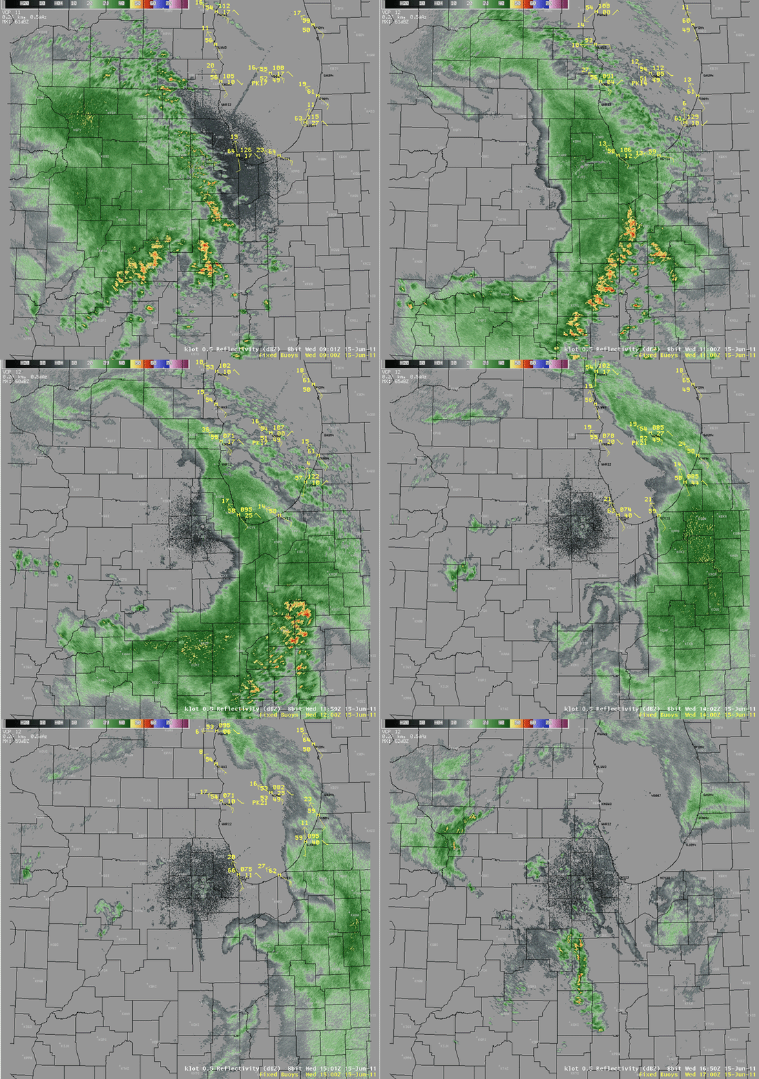
Figure 2:WSR-88D KLOT Base Reflectivity and Marine Observations

Figure 3: Atmospheric Pressure Chart Winthrop Harbor IL WHRI2
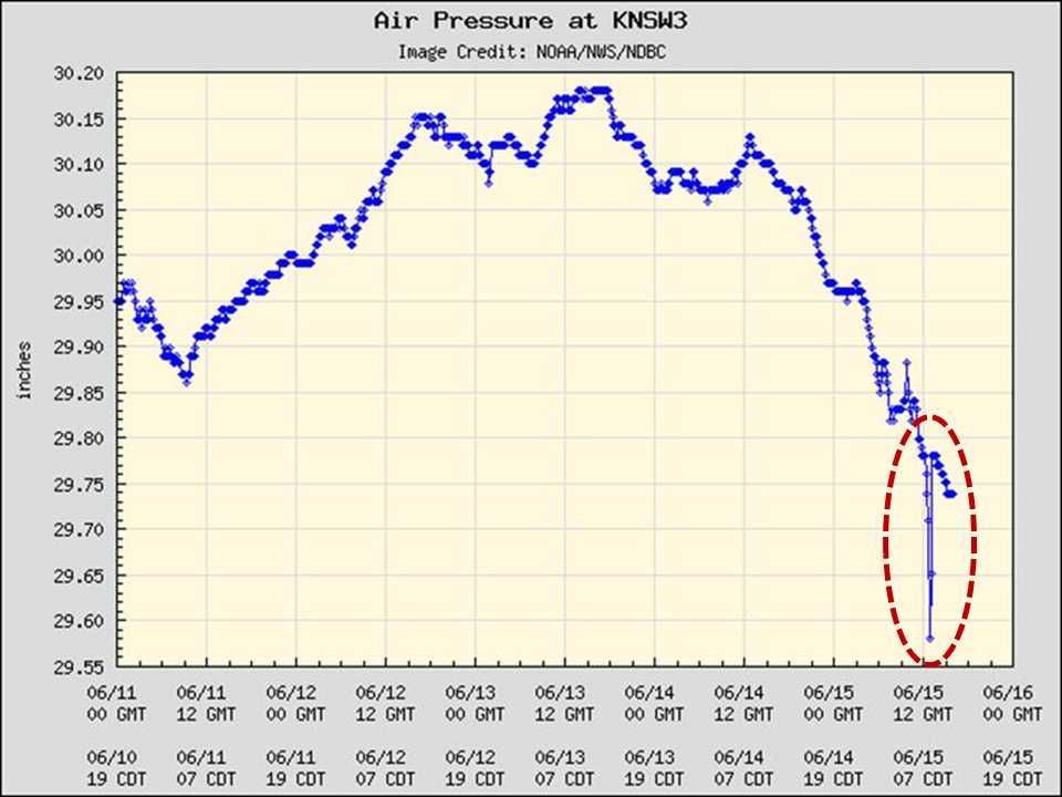
Figure 4: Same as Figure 3 (above) except for Kenosha WI KNSW3
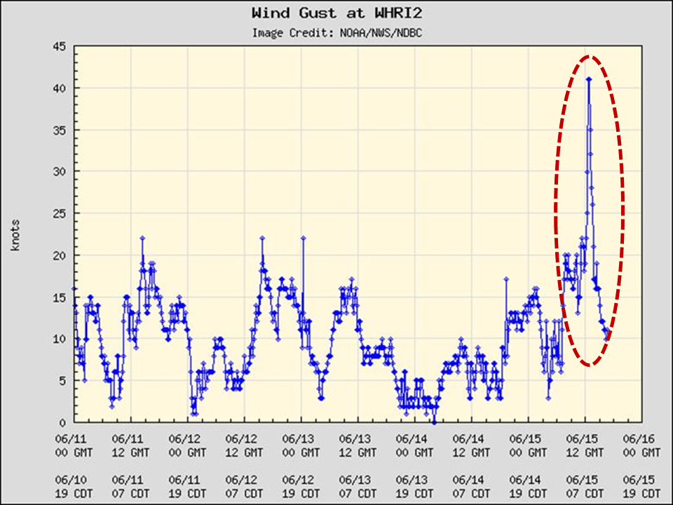
Figure 5: Wind Gust Chart Winthrop Harbor IL WHRI2
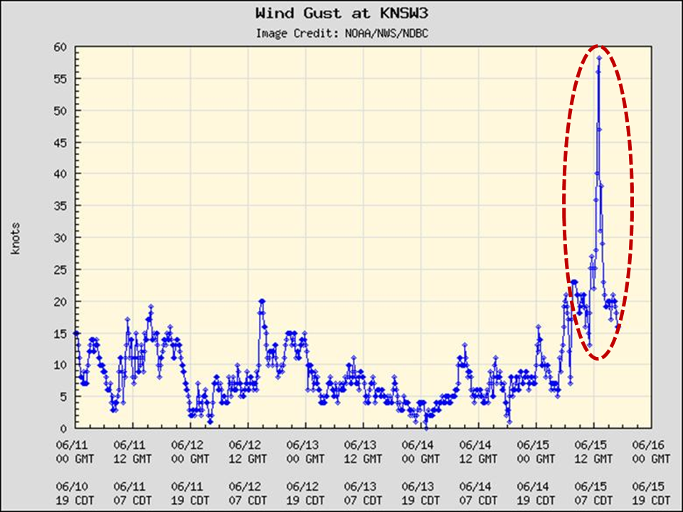
Figure 6: Same as Fig 5 (above) except for Kenosha WI KNSW3

Figure 7: Air Pressure Change Druce Lake IL
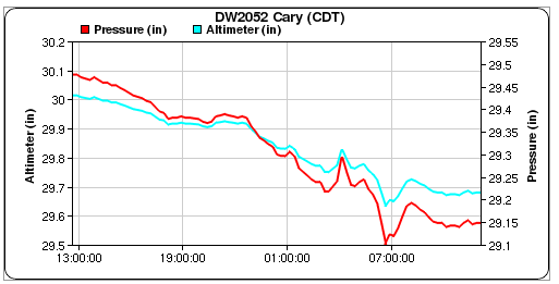
Figure 8: Same as Fig. 7 except for Cary IL
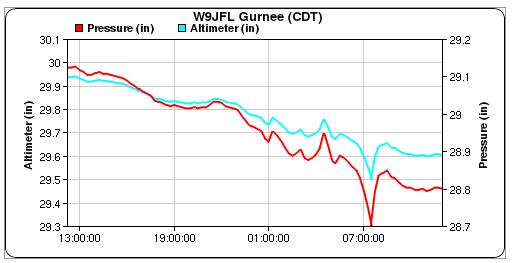
Figure 9: Same as Fig. 7 & 8 except for Gurnee IL
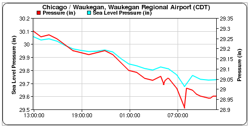
Figure 10: Same as Fig. 7,8, & 9 except for Waukegan IL
| TIME | LOCATION | OBSERVATION |
| 600 AM CDT | Kildeer, IL (LAKE COUNTY) | Large Tree Down |
| 700 AM CDT | Beach Park, IL (LAKE COUNTY) | Wind Gust: 55 MPH |
| 720 AM CDT | Libertyville, IL (LAKE COUNTY) | Wind Gust: 54 MPH |
| 735 AM CDT | Chicago Crib (CHII2) | Wind Gust: 48 MPH |
| 800 AM CDT | Waukegan, IL (LAKE COUNTY) |
Wind Gust: 45 MPH |
Hazards
Enhanced Hazardous Weather Outlook
Hazardous Weather Outlook
National Briefing
Skywarn
Outlooks
Watch/Warning/Advisory Criteria
Snow Squall Warnings
Local Forecasts
Text Products
Aviation
Marine
Fire
Enhanced Data Display (EDD)
Great Lakes Marine Portal
Lake Michigan Beach Forecast
El Nino
Snow and Ice Probabilities
Past Weather
Stormdata
Holiday Climate Data
Climate Plots
Weather Event Write-Ups
Education
Jetstream
Student Opportunities
NWS Training Portal
Play Time for Kids
US Dept of Commerce
National Oceanic and Atmospheric Administration
National Weather Service
Chicago, IL
333 West University Drive
Romeoville, IL 60446
815-834-1435 8am-8pm
Comments? Questions? Please Contact Us.

