Summary
|
|
|
Tornadoes
| Tornado timeline for April 9, 2015. |
Statement issued after the event:
PUBLIC INFORMATION STATEMENT...UPDATED
NATIONAL WEATHER SERVICE CHICAGO IL
1247 AM CDT WED APR 15 2015

...NWS DAMAGE SURVEY RESULTS FOR 04/09/15 TORNADO EVENT...

NWS METEOROLOGISTS HAVE NOW CONFIRMED SEVEN TORNADOES ACROSS
NORTH CENTRAL ILLINOIS FROM THE EVENING OF APRIL 9. NWS CHICAGO
WOULD LIKE TO EXPRESS APPRECIATION TO NASA SPORT FOR THE SATELLITE
IMAGERY...NOAA REMOTE SENSING DIVISION FOR THE HIGH RESOLUTION
AERIAL PHOTOGRAPHY...THE CIVIL AIR PATROL FOR AREAL
PHOTOGRAPHY...AS WELL AS THE ILLINOIS STATE POLICE AND THE MCHENRY
COUNTY EMERGENCY MANAGEMENT AGENCY FOR THEIR AERIAL DAMAGE PHOTOS
AS WELL. ALL OF THIS REMOTE SENSING DATA ALONG WITH THE GROUND
SURVEYS WERE INSTRUMENTAL IN IDENTIFYING THE TORNADO PATHS LISTED
BELOW AS WELL AS THE DAMAGE INTENSITY.

THE FIRST TORNADO WAS SPAWNED OVER FAR SOUTHEAST WINNEBAGO COUNTY
INTO BOONE COUNTY BY THE FIRST SUPERCELL THUNDERSTORM...WHILE THE
NEXT SIX TORNADOES FORMED FROM ONE POWERFUL AND LONG DURATION
SUPERCELL STORM...INCLUDING THE VIOLENT LONG TRACK EF-4 FROM
NORTHERN LEE COUNTY...THROUGH OGLE AND DEKALB COUNTIES...AND
ENDING IN FAR SOUTHERN BOONE COUNTY.

THE TORNADO COUNT FROM THE APRIL 9TH EVENT FOR THE NWS CHICAGO
COUNTY WARNING AREA STANDS AS FOLLOWS...

EF-4: 1
EF-1: 3
EF-0: 3

TORNADOES WERE ON THE GROUND FOR A TOTAL OF 43.5 MILES ACROSS
NORTH CENTRAL ILLINOIS.

HERE IS A LISTING OF THE CONFIRMED TORNADOES...
|
|
| Maps showing the track of the Rochelle-Fairdale EF-4 tornado |
RATING:                 EF-4
ESTIMATED PEAK WIND:    200 MPH
PATH LENGTH /STATUTE/:  30.2 MILES
PATH WIDTH /MAXIMUM/:   700 YARDS
FATALITIES:             2
INJURIES:               22

START DATE:APRIL 09 2015
START TIME:6:39 PM CDT
START LOCATION:0.9 MILES NE FRANKLIN GROVE
START LAT/LON:          41.8530/-89.2896

END DATE:APRIL 09 2015
END TIME:7:20 PM CDT
END LOCATION:5 NNW KIRKLAND
END LAT/LON:            42.1623/-88.8792

THIS LONG TRACKED VIOLENT TORNADO DESTROYED NUMEROUS HOMES AND
FARMSTEADS...AS WELL AS TOSSED VEHICLES...ALONG ITS PATH FROM
NORTH CENTRAL LEE COUNTY ACROSS EASTERN OGLE...NORTHWEST
DEKALB...INTO EXTREME SOUTHERN BOONE COUNTY. THIS INCLUDED ACROSS
THE FAR NORTHWEST SIDE OF ROCHELLE...ACROSS INTERSTATE 39...AND
DIRECTLY THROUGH FAIRDALE.
 |
| Map showing the track of the Cherry Valley tornado |
RATING:                 EF-0
ESTIMATED PEAK WIND:    65 MPH
PATH LENGTH /STATUTE/:  2.8 MILES
PATH WIDTH /MAXIMUM/:   25 YARDS
FATALITIES:             0
INJURIES:               0

START DATE:             APRIL 09 2015
START TIME:6:37 PM CDT
START LOCATION:         2.9 MILES S CHERRY VALLEY
START LAT/LON:          42.1926/-88.9548

END DATE:               APRIL 09 2015
END TIME:6:40 PM CDT
END LOCATION:           2.5 MILES SE CHERRY VALLEY
END_LAT/LON:            42.2174/-88.9106

AN EMERGENCY MANAGER AND TRAINED SPOTTERS PHOTOGRAPHED A
TORNADO THAT TOUCHED DOWN SOUTH OF CHERRY VALLEY. THE
TORNADO DID NOT PRODUCE ANY DAMAGE.
RATING:                 EF-0
ESTIMATED PEAK WIND:    65 MPH
PATH LENGTH /STATUTE/:  1.9 MILES
PATH WIDTH /MAXIMUM/:   100 YARDS
FATALITIES:             0
INJURIES:               0

START DATE:APRIL 09 2015
START TIME:7:05 PM CDT
START LOCATION:2.9 MILES E LINDENWOOD
START LAT/LON:          42.0583/-88.9752

END DATE:APRIL 09 2015
END TIME:7:08 PM CDT
END LOCATION:4.6 ENE LINDENWOOD
END LAT/LON:            42.0739/-88.9457

THIS BRIEF SATELLITE TORNADO OVER FAR EASTERN OGLE COUNTY WAS
CONFIRMED USING AERIAL SURVEY INFORMATION AND RADAR DATA.
 |
| Map showing the track of the Kirkland tornado |
RATING:                 EF-1
ESTIMATED PEAK WIND:    110 MPH
PATH LENGTH /STATUTE/:  4.0 MILES
PATH WIDTH /MAXIMUM/:   100 YARDS
FATALITIES:             0
INJURIES:               0

START DATE:             APRIL 09 2015
START TIME:             7:15 PM CDT
START LOCATION:         3.1 MILES NW KIRKLAND
START LAT/LON:          42.1334/-88.8776

END DATE:               APRIL 09 2015
END TIME:               7:21 PM CDT
END LOCATION:           6 MILES S BELVIDERE
END_LAT/LON:            42.1786/-88.8287

THIS TORNADO PATH WAS IDENTIFIED USING STORM CHASER VIDEO...GROUND
SURVEY AND AERIAL SURVEY INFORMATION. THE TORNADO FORMED IN FAR
NORTHWEST DEKALB COUNTY AND LIFTED IN FAR SOUTHERN BOONE COUNTY.
 |
| Map showing track of the Belvidere tornado |
RATING:                 EF-0
ESTIMATED PEAK WIND:    85 MPH
PATH LENGTH /STATUTE/:  0.4 MILES
PATH WIDTH /MAXIMUM/:   30 YARDS
FATALITIES:             0
INJURIES:               0

START DATE:             APRIL 09 2015
START TIME:7:24 PM CDT
START LOCATION:         3.8 MILES S BELVIDERE
START LAT/LON:          42.2073/-88.8425

END DATE:               APRIL 09 2015
END TIME:               7:25 PM CDT
END LOCATION:           3.9 MILES S BELVIDERE
END_LAT/LON:            42.2020/-88.8465

THIS TORNADO WAS SPAWNED BY THE SAME STORM THAT PRODUCED THE LONG
TRACK EF-4 SHORTLY AFTER THAT TORNADO LIFTED.
 |
| Map showing the track of the Garden Prairie tornado. |
RATING:                 EF-1
ESTIMATED PEAK WIND:    110 MPH
PATH LENGTH /STATUTE/:  3.9 MILES
PATH WIDTH /MAXIMUM/:   50 YARDS
FATALITIES:             0
INJURIES:               0

START DATE:             APRIL 09 2015
START TIME:7:25 PM CDT
START LOCATION:         6 MILES SE BELVIDERE
START LAT/LON:          42.2442/-88.7386

END DATE:               APRIL 09 2015
END TIME:7:31 PM CDT
END LOCATION:           5.6 MILES ESE BELVIDERE
END_LAT/LON:            42.1942/-88.7748

THIS TORNADO WAS SPAWNED BY THE SAME STORM THAT PRODUCED THE LONG
TRACK EF-4 SHORTLY AFTER THAT TORNADO LIFTED.
RATING:                 EF-1
ESTIMATED PEAK WIND:    90 MPH
PATH LENGTH /STATUTE/:  0.3 MILES
PATH WIDTH /MAXIMUM/:   30 YARDS
FATALITIES:             0
INJURIES:               0

START DATE:             APRIL 09 2015
START TIME:             7:50 PM CDT
START LOCATION:         4.4 MILES EAST SOUTHEAST OF HARVARD
START LAT/LON:          42.3982/-88.5309

END DATE:               APRIL 09 2015
END TIME:7:51 PM CDT
END LOCATION:           4.6 MILES EAST SOUTHEAST OF HARVARD
END_LAT/LON:            42.4019/-88.5272

THIS BRIEF TORNADO SNAPPED AND UPROOTED 6 TO 7 TREES AT A
PROPERTY ON MCGUIRE ROAD SOUTHEAST OF HARVARD THEN CAUSED MINOR
TREE DAMAGE ON THE NORTH SIDE OF THE ROAD BEFORE ENDING.
The Enhanced Fujita (EF) Scale classifies tornadoes into the following categories:
| EF-0 Weak 65-85 mph |
EF-1 Moderate 86-110 mph |
EF-2 Significant 111-135 mph |
EF-3 Severe 136-165 mph |
EF-4 Extreme 166-200 mph |
EF-5 Catastrophic 200+ mph |
 |
|||||
Radar
 |
| This is a loop of radar data from 6:15 PM through 8:00 PM on April 9th, 2015 showing the life cycle of the Rochelle-Fairdale tornado. The loop follows the storm from initial tornado touchdown near Franklin Grove in north-central Lee County to the Illinois/Wisconsin state line. From top-left to bottom-left in a clockwise manner, the images displayed are: Base Reflectivity, Storm-Relative Velocity, Correlation Coefficient, and Spectrum Width. Note that there are several frames showing velocity dealiasing failures in the Storm-Relative Velocity panel. |
|
|
 |
| This image, taken at 7:13 PM, is a cross section of a radar product called Correlation Coefficient from near Cherry Valley to Esmond. North is to the left and east is into the image. This dual polarization radar product shows the correlation between energy return in both the horizontal and vertical directions. Large differences in these values can indicate the presence of non-meteorological objects, such as dirt, insects, or birds, which show up as very low values. In this case, the low Correlation Coefficient values (greens and blues) are from debris picked up by the tornado which is being lofted high into the updraft of the thunderstorm. |
A composite image showing NWS Doppler Radar rotation tracks from 4-10 PM. Brighter colors (yellows and reds) indicate higher values of rotation in this image. |
 |
  |
|
Clockwise from top left: [6:39 PM] Tornado initially touches down 1 mile northeast of Franklin Grove near the Lee/Ogle county line. Damage to buildings can be seen near Illinois Route 38 in aerial imagery. [7:02 PM] Tornado is near peak intensity (EF-4) as it approaches I-39 north of Rochelle and Hillcrest. [7:13 PM] Tornado crosses into DeKalb County and moves across the town of Fairdale where significant damage is noted. |
|
Environment
 |
| Surface Weather Setup |
Climatology
The peak tornado season in Illinois is April through June. See our Severe Weather and Tornado Climatology Page for more.
This was the first EF-4 tornado or stronger in Illinois since two EF-4 tornadoes occurred on November 17, 2013, including one that struck the community of Washington. This was the 33rd EF-4 or stronger tornado in Illinois on record (since 1950).
This was the first EF-4 or stronger tornado in the NWS Chicago County Warning Area in 25 years, since an F5 tornado struck Plainfield on August 28, 1990.
This was the strongest tornado on record (since 1950) for Ogle County, where EF-4 damage was observed. The previous strongest tornado on record in Ogle County since 1950 was an F-3 on August 5, 1979. The last tornado in Ogle County prior to April 9, 2015 was May 22, 2011, when three EF-1 tornadoes occurred.
This was the strongest tornado on record (since 1950) for DeKalb County, where EF-3 damage was observed. The previous strongest tornado on record in DeKalb County since 1950 was an F-2 on June 18, 1975. The last tornado in DeKalb County prior to April 9, 2015 was an EF-0 on May 13, 2011.
|
NWS Services leading up to and during the tornado event on April 9, 2015 |
Photos
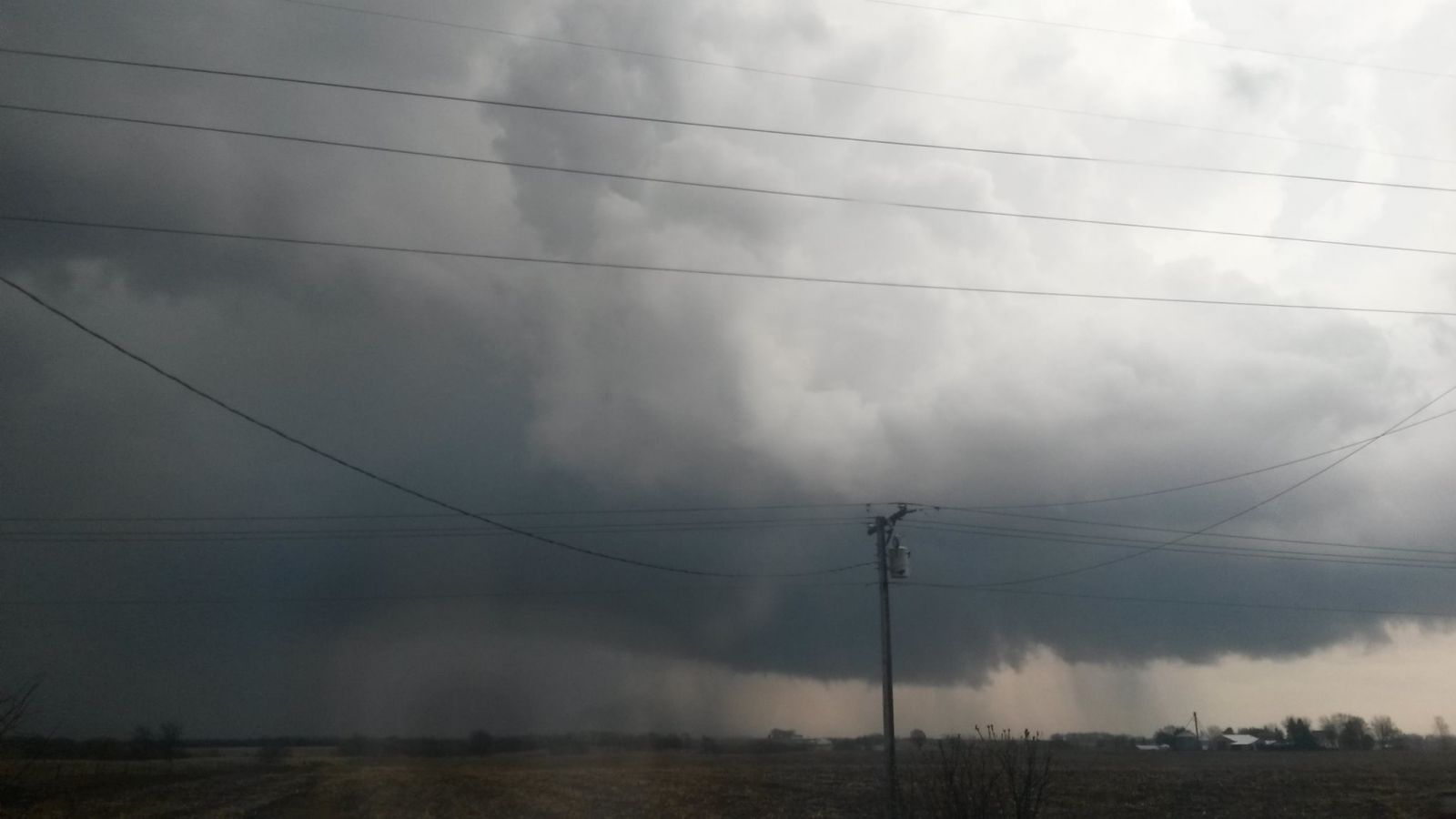
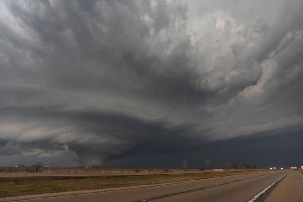
The following photos are all of the Rochelle-Fairdale, IL EF4 tornado. Because this tornado could be seen from quite some distance away, there were many photos of it. It is important to remember safety first, as many of these photos came from trained storm spotters who knew they were not in the direct path of this tornado and were extremely aware of their surroundings. If in a tornado warning, ensure you are in shelter. Tornadoes can be deceptive, especially ones this large, and you may not realize it is headed directly for you! Also remember to not take photos while driving!
For more, see our Facebook photo album.
 |
|
| Near Dixon, IL. The beginning of the low-level rotation with the storm. Courtesy of Lora Ludwig. | Near Ashton, IL. Courtesy of Jodi Mair. |
 |
|
| Near Ashton, IL. Courtesy of PBrooks Photography. | West of Rochelle, IL. Courtesy of Dean Schultz. |
 |
| North of Rochelle, IL. Courtesy of Caleb Peters. |
 |
|
| Tornado at peak intensity near IL Highways 64 and 251, just west of I-39. Courtesy of Dr. Walker Ashley of the NIU Meteorology Department. | Tornado at peak intensity near IL Highways 64 and 251, just west of I-39. Courtesy of Jodi Mair. |
 |
| Hail with the supercell storm that produced the EF4 tornado. Courtesy of Jeff Grubich. |
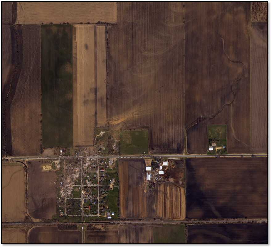
The NWS had boots on the ground for their survey, working closely with Emergency Management. Also used in the process of quantifying exactly what happened and to what magnitude and extent was aerial imagery for this event. This includes from aircraft and polar orbiting satellites.
 |
  |
| Click here for more high altitude imagery for this event acquired by the NOAA Remote Sensing Division to support NOAA. Individual images have been combined into a larger mosaic and tiled for distribution. The approximate ground sample distance for each pixel is 1.64 feet. | Landsat-8 Satellite image clearly showing the track of the tornado (Darkened line area northwest of Rochelle, IL) |
 |
|
| Northwest Rochelle area. Courtesy of Civil Air Patrol. | North of Rochelle area looking southwest. Courtesy of Civil Air Patrol. |
 |
|
| Another view of damage to a neighborhood northwest of Rochelle showing high-end EF4 impacts to homes. Courtesy Air-One and photographer Dave Youngblut. | Fairdale, IL. Courtesy of Civil Air Patrol. |
 |
|
| Northwest side of Rochelle, IL. | North of Rochelle, IL. |
 |
| Fairdale, IL. |
 |
| Fairdale, IL. |
 |
|
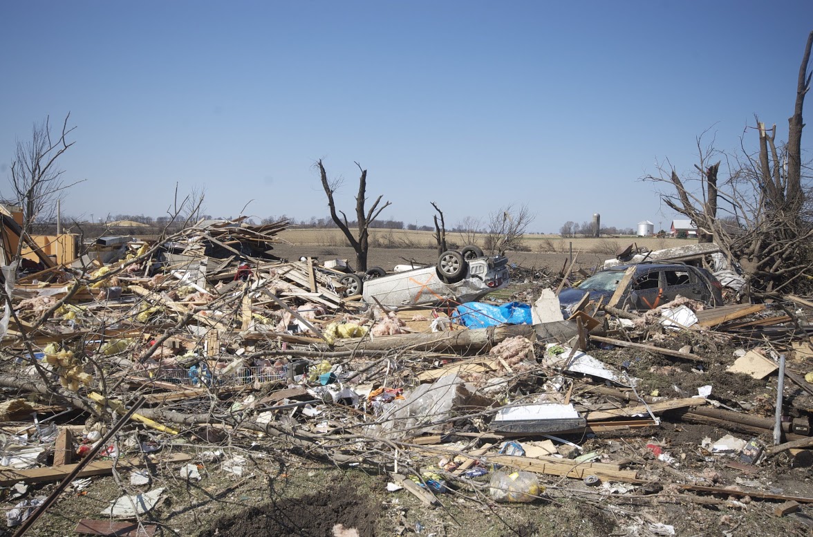
| Fairdale, IL. | Fairdale, IL. |
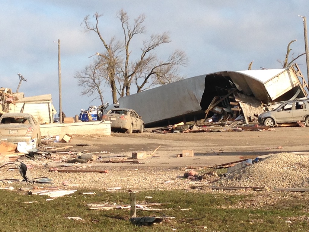
Public Damage Photos:
 |
|
| At the Intersection of Illinois Highways 64 and 251 north of Rochelle. | |
Accounts
Accounts collected at the 5-year anniversary in 2020.
| For more accounts, see our Facebook post. | |
Here is an amazing account we wanted to share in its entirety. This is from Mel Jamie, who was working that evening at the Grubsteakers restaurant that was destroyed north of Rochelle by the EF4 tornado.
"I remember that day, very distinctly. I was working that evening at Grubsteakers. The very beginning of that day something felt off. It had been gloomy all day long and eventually the weather got very nasty. I’m afraid of storms anyway, I always have been. So my anxiety was through the roof.
Customers were constantly updating us on the weather and then all of a sudden every persons phone, in that restaurant, went off at once. After that it always kind of hazy to me. Customers said there was a tornado coming right at us. I looked out the window and there it was. It was massive. I froze. I stood there looking out the window with tears running down my cheeks and I couldn’t move. The owner of the restaurant grabbed me by the arm. She said we have to get to the basement now. It was a blur to me but I remember people running after us. The head cook at that time made sure that he got every customer out of that restaurant. He was the last one into the basement. It was one of those old-time cellar type basements where the doors open up to the left into the right. It was his job to close the door. He said the very last thing that he saw through the cracks, while fighting with the door, was the garage takeoff flying in the other direction.
I remember that the tornado sounded just like a freight train as it passed over us. I remember being stuck in that basement worried about my family and my friends. We were completely in the dark and we couldn’t get the doors open and I don’t remember much more about the basement than that. The next thing I remember is the fire department and rescue working hard to get us out. They made a hole big enough for a person to squeeze through and I was the first one out. The first thing I saw was my car, still where I left it, covered in dust and dirt and building materials with every window broken and the bumper torn off and a 2 x 4 through the window of the car. It looked like it had gone through a demolition derby. The next thing I remember seeing is a mangled semi truck where the garage used to be. And then I turned to look at the building and I saw that it had been completely flattened. The only thing remaining of that building was three walls of the walk in cooler.
So much of the community came out to help us in the days and weeks after. It was a humbling experience. It was an amazing thing to see everybody come together to help their neighbors in their time of need. That’s a good thing that I take from this experience. It’s hard to believe that it’s been five years. It seems like 100 years ago and it seems like yesterday. And because of that day, April 9, 2015, I am not grateful for every single day." - Mel Jamie
 |
Media use of NWS Web News Stories is encouraged! Please acknowledge the NWS as the source of any news information accessed from this site. Additional recaps can be found on the NWS Chicago Past Events Page |
 |
Note: This service is not intended for secure transactions such as banking, social media, email, or purchasing. Use at your own risk. We assume no liability whatsoever for broken pages.
Alternative Proxies: