
If you are looking for fresh snow by Christmas morning or are curious about potential travel disruptions, the best chances for at least 1" of new snowfall early this week exist across the mountainous West, Great Lakes, and Northeast. Otherwise, temperatures this last full week of December will average above normal for much of the lower 48 states. Read More >
Friday, August 28, 2023 marks 33 years since Plainfield, IL and adjacent communities of the far southwestern Chicago metro were struck by the strongest August tornado on record in the United States. That late summer day will long be remembered by residents of northern Illinois due to the lives the tornadoes took and the devastation it caused. This page serves as a collection of information from that event, including accounts shared by many public citizens, as well as a description of advances in meteorology, communication, and readiness over the past three decades.
Overview
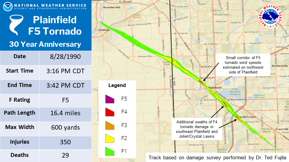
Between 3:15 p.m. and 3:45 p.m. CDT on August 28th, 1990, a violent F5 tornado ripped through Kendall and Will counties taking the lives of 29 people and injuring 350. The tornado left a 16.4 mile-long damage path which ranged from 600 yards to a half a mile in width. An estimated total of $160 million dollars in damages was added up with a total of 470 homes destroyed and 1000 damaged.
Not only was this F5 tornado disastrous, it was also very unusual for several reasons:
 |
|
Map of the Plainfield tornado's track, based on a damage survey performed by Dr. Ted Fujita |
 |
 |
 |
| Close-up of track over the Wheatland Plains subdivision | Close-up of track over Plainfield | Close-up of track over the Joliet/Crest Hill area |
 |
 |
| Maps showing parts of present-day Plainfield with roads impacted by the tornado that were present in 1990 (red) and newer roads that were built afterwards (green), showing just how much more of an impact this tornado would have had if it occurred today. | |
 |
 |
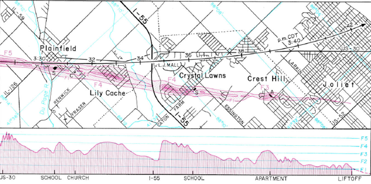 |
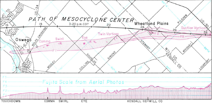
| The original storm survey work by the late Dr. Theodore Fujita of the University of Chicago. | ||
Before the Enhanced Fujita Scale was put in use in 2007, the tornado damage was assessed by using the Fujita Scale. On the Fujita Scale, an F5 tornado has estimated wind speeds of 261-318 mph and is defined as having incredible damage in which strong frame houses can be leveled and swept off of foundations, automobile-sized objects can be lifted up into the air, and trees are usually debarked.
Damage Photos
Aerial Damage Photos
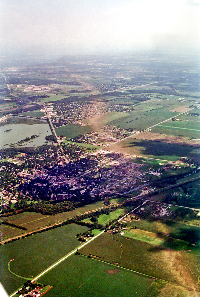 Aerial view of tornado damage path through southern Plainfield. View is from just northwest of Plainfield looking southeastward. Photo attribution unclear, potentially Steve Longmire |
|
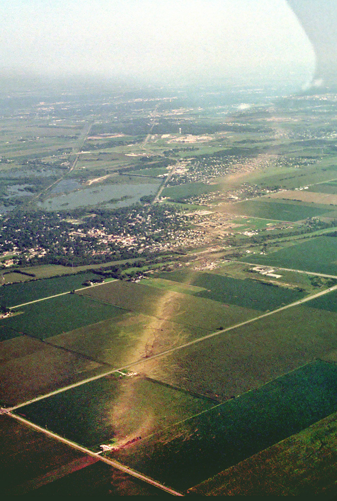 View is from near 143rd Street and Wallin Drive northwest of Plainfield looking southeastward. Some of the most intense damage of the entire track occurred near the center of this photo. Photo attribution unclear, potentially Steve Longmire |
||
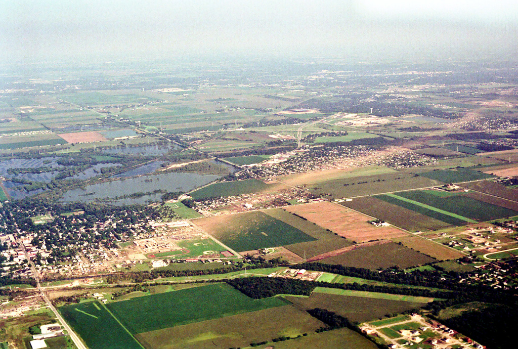 View is from just west of Plainfield looking east-southeastward. Photo attribution unclear, potentially Steve Longmire |
 View is from just west of Plainfield looking eastward. Photo attribution unclear, potentially Steve Longmire |
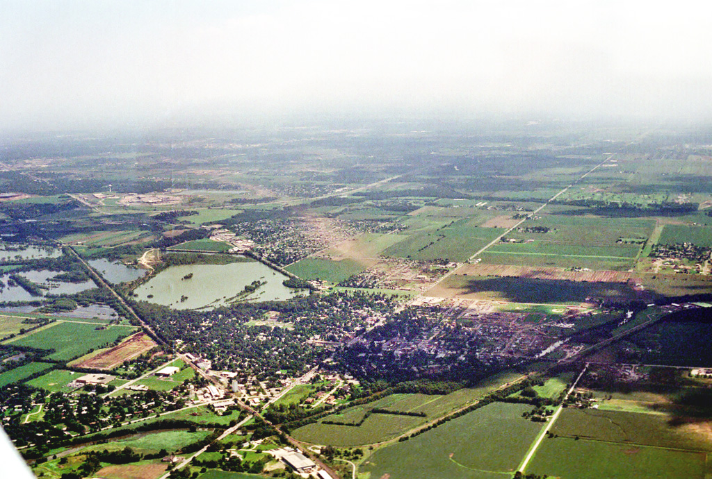 View is from just northwest of Plainfield looking south-southeastward. Photo attribution unclear, potentially Steve Longmire |
Accounts
 |
||
For more, see our 2020 Facebook Post. Also see our 2015 Facebook Post at the 25th Anniversary.
Meteorology
The atmospheric conditions that spawned this deadly storm were typical of those that lead to severe weather. An upper-level shortwave trough was moving through the Great Lakes area, while below a cold front was forecast to push its way south through northern Illinois. These were the focusing mechanisms for severe weather.
In fact, the necessary recipe for severe weather was all present: moisture, instability, a source of lift, and wind shear were all present. There was one ingredient for tornadoes though that appeared to be missing: a sharp change in wind speed and direction in the lower levels (~5,000 ft) of the atmosphere. Deep layer shear (~3,000 to 35,000 ft) was certainly considerable, with strong upper-level winds supportive of multicell and supercell storms with damaging winds and large hail. Without low-level shear, however, the data suggested that tornadoes may not be a prominent threat.
 |
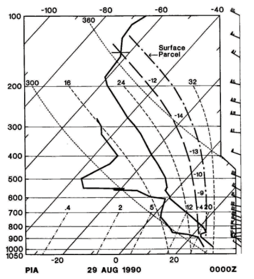 |
| 2 p.m. CDT August 28, 1990 surface map showing the hot and moist air mass in place with a cold front pushing in. | 7 p.m. CDT August 28, 1990 Peoria, IL weather balloon launch data. Noted on this sounding plot is a massive amount of instability and winds increasing in speed above 5,000 ft. |
On August 27, the National Severe Storms Forecast Center (NSSFC) in Kansas City, Missouri (predecessor to the Storm Prediction Center, or SPC of Norman, Oklahoma), issued a severe weather outlook which indicated a risk for severe storms in the Great Lakes region, including northern Illinois, the following day. During the overnight hours into August 28, an updated outlook continued to indicate a "slight risk" of severe storms in the area. At 9:52 AM CDT, the NSSFC upgraded their severe thunderstorm outlook for northern Illinois from a Slight to a Moderate Risk, suggesting a greater coverage of damaging storms.
 |
 |
 |
|
Severe weather outlook issued by the NSSFC on August 27, 1990, for August 28. |
Severe weather outlook issued by the NSSFC during the overnight hours early on August 28, 1990. |
Severe weather outlooks issued by the NSSFC during the day on August 28, 1990. |
At 1:28 p.m., NSSFC issued a Severe Thunderstorm Watch for portions of northern Illinois. After thunderstorms began to develop near the north central Illinois and Wisconsin border around noon, conditions increasingly began to favor supercells. CAPE (Convective Available Potential Energy) values rose from 4000 J/kg across much of northern Illinois to an incredible 7000 J/kg by 3:00 p.m., giving thunderstorms extremely explosive energy. The cold front could be seen almost exactly crossing the state border at this time, with the high values south representative of very warm temperatures in the mid to upper 90s and oppressive dew points reaching the upper 70s.
Despite the continued lack of pronounced low-level shear, the impressive parameters for supercell growth allowed an initial storm to quickly produce one or two brief tornadoes near Pecatonica and Seward, Illinois, just west of Rockford at 1:42 p.m. This occurred shortly after the NSSFC issued a Severe Thunderstorm Watch for the area at 1:28 p.m. As a dominant storm emerged later and ventured further into extreme instability and strong shear, it exploded to a height of over 65,000 feet and displayed classic supercell behavior, including a hook echo and southeast movement to the right of the upper-level winds that would normally steer it. This motion brought the storm through DeKalb and Kane Counties as it dealt strong winds and a swath of golf ball to tennis-ball sized hail.
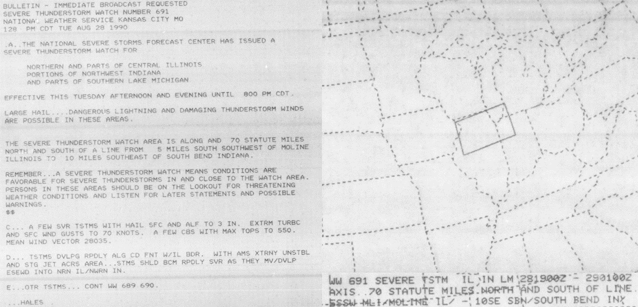 |
| Severe Thunderstorm Watch issued for northern Illinois and northwestern Indiana at 1:28 PM CDT on August 28, 1990. From Iowa State University's IEM microfilm archive of SELS/NSSFC products. |
Imagery collected by the WSR-74 radar site MMO on August 28, 1990, showed a strong echo moving southeastward from near Rockford to near Joliet during the early afternoon hours. Between DeKalb and Joliet, radar data indicated a hook echo on the storm, which was most evident as it moved into northwestern Will County.
 |
 |
 |
|
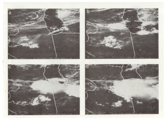
GOES visible images showing the development and progression of thunderstorms across northern Illinois at (a) 12:46 pm CDT; (b) 1:46 pm CDT; (c) 2:46 pm CDT; and (d) 3:46 pm CDT on the afternoon of August 28. Photo from the Natural Disaster Survey Report. |
Animation of digitized radar imagery from the MMO WSR-74 radar site on August 28, 1990, from 12:46 PM to 3:49 PM CDT. Created from a combination of archived radar display photos in the Natural Disaster Survey Report and the technical report "Plainfield Tornado of August 28, 1990" by Theodore Fujita, and also analysis of archived hand contours of radar imagery. |
Animation of digitized radar imagery from the MMO WSR-74 radar site on August 28, 1990, from 1:46 PM to 3:49 PM CDT, zoomed in to the western Chicago suburbs. Created from a combination of archived radar display photos in the Natural Disaster Survey Report and the technical report "Plainfield Tornado of August 28, 1990" by Theodore Fujita, and also analysis of archived hand contours of radar imagery. |
As this storm continued to build, a change in low-level winds was observed. Once generally northwest, surface winds quickly backed to the southwest. With surface winds out of the southwest and the upper-level winds from the northwest, the change in wind direction allowed nearly 90 degrees of directional shear with height; more than necessary for rotating storms and increasing the tornado threat.
Unfortunately, that turning in such an extremely unstable atmosphere was all that was necessary for the devastation caused on this day. The supercell first dropped four separate brief tornadoes in rural southern Kane County, but after these attempts it was able to fully realize the wind shear it had been born into and formed an extremely powerful tornado near Oswego in Kendall County.
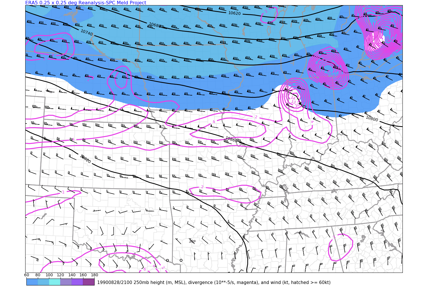
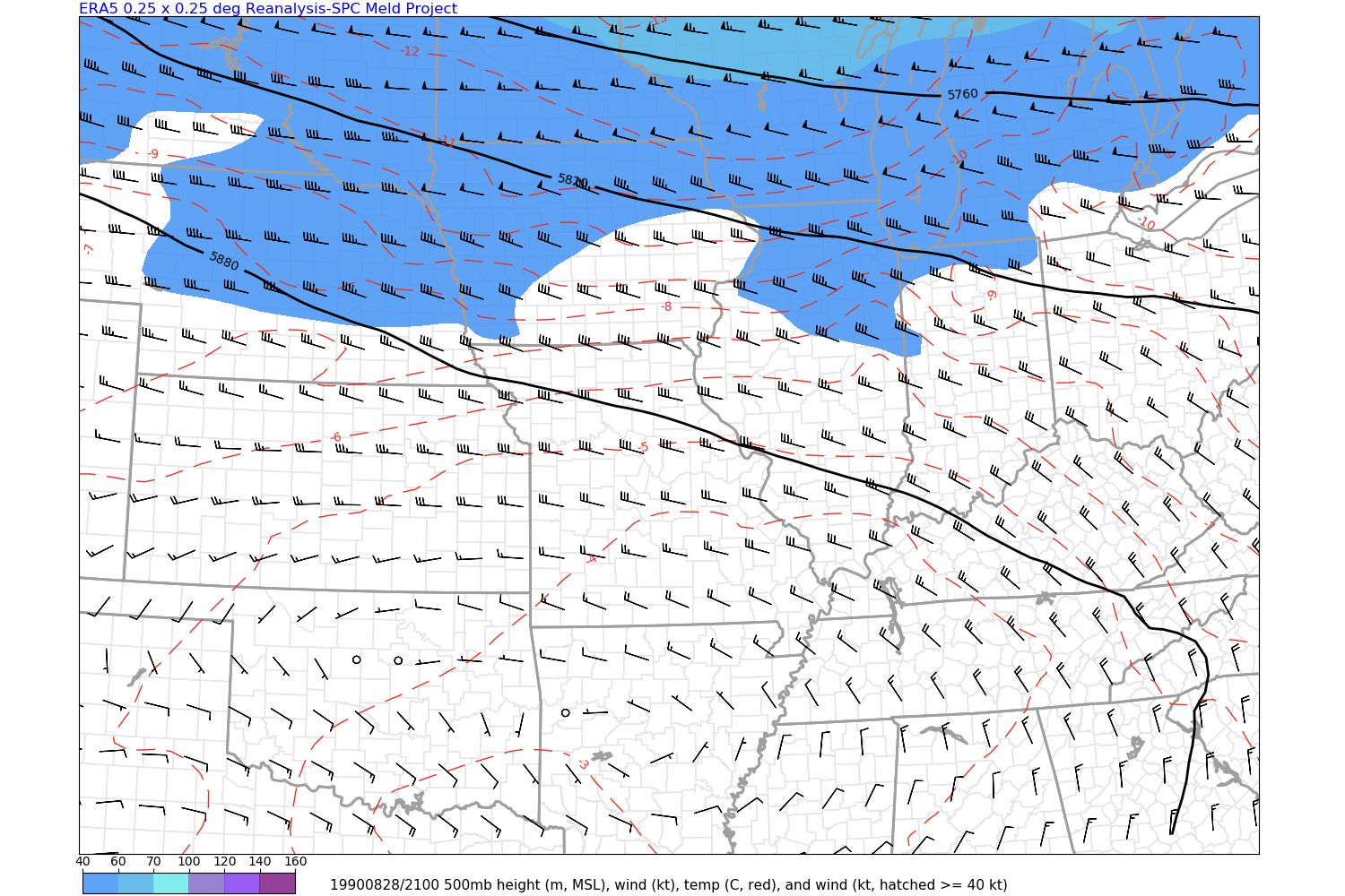
Reanalysis of the meteorological environment from that day can also shed light to the ingredients that were at work. Below are some reanalyzed images from the ERA5 dataset that was created from observational data that day. These images focus on kinematics (wind fields and associated parameters) from August 28, 1990. Note these images are not from the NWS Storm Prediction Center (SPC), but were analyzed so the output is in a format consistent with their Hourly Mesoanalysis that NWS forecasters use in real-time during severe weather events.
 |
 |
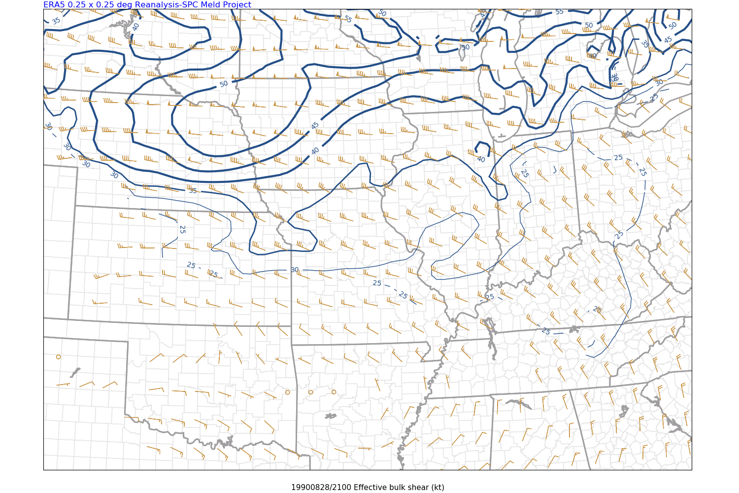 |
| Aug 28, 1990 4 p.m. CDT: Reanalyzed 250 mb heights, winds, and divergence | Aug 28, 1990 4 p.m. CDT: Reanalyzed 500 mb heights, winds, and temperatures | Aug 28, 1990 4 p.m. CDT: Reanalyzed effective deep layer shear |
As shown by these reanalysis images, the strong upper level (250 mb) and mid level (500 mb) winds, known as jet streaks, were shifting southward and their influence was quickly spreading over the area in the afternoon. The analyzed 250 mb winds of 80-85 kt impinging into northern Illinois is right at record levels for late August over northern Illinois using the SPC Sounding Climatology dataset. This setup, especially at peak heating time in the afternoon (i.e. combined with explosive instability), was favorable for a region of robust ascent and well-organized storm structure. The effective shear of 40+ kt was sufficient for sustained supercell storm structure.
Here is a reanalyzed sounding, or vertical atmospheric profile plot, also from the ERA-5 dataset. This is for 1 p.m. that afternoon in Romeoville, IL which is just a few miles away from where the tornado tracked. This is modified for the temperature (91°) and dew point (76°) observed in the area at that time.
 |
| Aug 28, 1990 1 p.m. CDT reanalyzed sounding for Romeoville, IL |
This reanalyzed sounding indicates the extreme instability (6,000 J/kg+) that was observed in the region by the Peoria (PIA) sounding later that day. The wind barbs gradually turn and increase in speed with height, characterizing the wind shear of that day. The low-level turning is not particularly strong but it's sufficient for supercells, especially in the proximity of any near-surface backing of the winds. This may have been the case that day near a meteorological boundary/discontinuity. Also a possibility was that ahead of the storm cluster moving from north central Illinois, the low-level winds increased, possibly only an hour or so in advance, but enough to markedly increase the low-level shear.
This sounding really captures a northwest flow severe weather event in the Midwest. The low-level winds do not have to necessarily be from the due south for a potent tornado setup, and the extreme instability and deep layer shear and turning can compensate for a marginal-modest low-level shear profile. As a very interesting point on this sounding, see the Sounding Analogue System (SARS) on the bottom center for dates that had similar observed soundings to this reanalyzed profile. The two supercell storm mode dates listed in the region are indeed August 28, 1990 (Peoria sounding) and the July 13, 2004 afternoon sounding from NWS Central Illinois (ILX), which was a day that saw a violent F-4 tornado strike near Roanoke, IL. That too was a potent northwest flow event during summertime.
Advancement
Advancements over the Past 30 Years
For the 25th anniversary of the 1990 Plainfield tornado in 2015, we attempted to summarize some of the key advances in meteorology that had taken place since that event. Over the past five years, additional remarkable advances have continued to change the way we forecast, warn for, and communicate the threats posed by severe thunderstorms and tornadoes. This information was compiled by former student volunteers Nicole Batzek and Cameron Nixon as well as past and present staff of NWS Chicago.
Some of the information below was shared at the 25th Anniversary and some pertains to even more recent advances. These fall into the following categories:
Within the science of computer programming, the practice of numerical modeling has grown from almost nonexistent to being a vital part of the forecast process.
In 1990, few computer models existed and those that did were not nearly as advanced as they are today.
Now, numerous, highly complex models including the GFS (Global Forecast System), the ECMWF (European Model), the NAM (North American Mesoscale), the RAP (Rapid Refresh), and the HRRR (High-Resolution Rapid Refresh) can provide insight into weather conditions, including those favorable for severe weather hours, days, and even a week in advance.
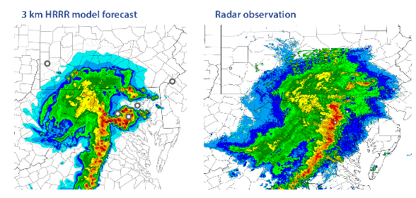 |
| Model simulation of radar reflectivity vs. actual observation of a derecho event in the Mid-Atlantic. |
The observation of current weather conditions has grown from spotty and infrequent to dense and continuous. Now, ASOS (Automated Surface Observing System) stations cover the country, and “mesonets” are being created that monitor subtle changes in very specific locations, providing exceedingly high spatial and temporal data.
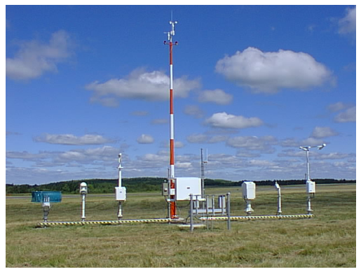 |
| Automated Surface Observing System (ASOS) |
Weather Radar has also become increasingly more effective in “seeing” through the inner workings of thunderstorms.
In 1990, the NWS Chicago radar used 1974 technology which could only tell us the intensity of precipitation, leading us to infer storm types based on patterns. Warning forecasters, who were remotely located from the radar site, could only view basic data on a TV monitor, and needed to have details of what the radar operator was seeing relayed to them through radar summary products or by phone.
The current NWS Chicago radar, which is located at the Weather Forecast Office, is more powerful with much higher resolution. Thanks to Doppler capability, it can detect motion within a storm, allowing us to know if and where it is rotating or showing signs of producing a tornado. In addition, it features Dual-Polarization technology, which can distinguish between rain, hail, ice, snow and other material, and in some cases can serve as an alert that a tornado is on the ground by detecting debris!
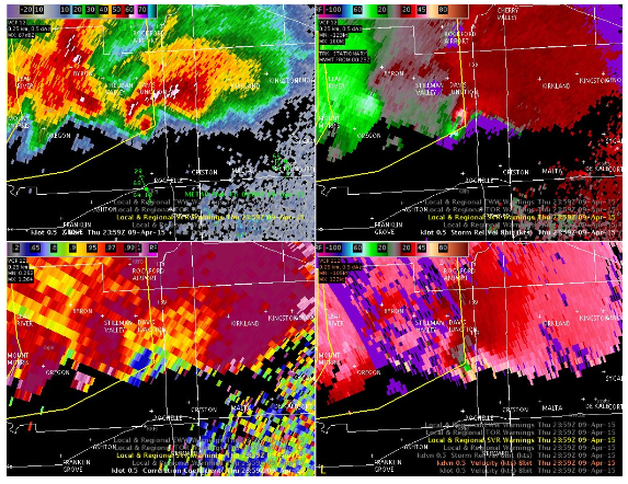 |
| Dual Polarization Radar image. See below for a more extensive discussion of recent advances in radar technology. |
Beyond radar, another very significant advance has been the deployment of new GOES satellites starting in 2017. Unlike previous satellites which had relatively coarse resolutions, less frequent updates, and slower data delivery, the new GOES satellites can scan portions of the United States looking at 16 different wavelengths of energy using a horizontal resolution from 0.5 to 2 km, a time resolution of 1 minute, and a data latency of just 1 minute. The information in the 16 wavelengths can be combined to tell a forecaster things like whether a storm may start producing lightning, or the apparent strength of the updraft in a storm based on the temperature of the overshooting top relative to the rest of the thunderstorm anvil.
| Click image for 14-hour satellite loop of the 10 August 2020 derecho shared on Twitter. |
The new GOES satellites also contain a Geostationary Lightning Mapper that helps forecasters track trends in lightning activity and anticipate thunderstorm intensification.
 |
| Satellite image courtesy of NWS Green Bay |
When it comes to monitoring evolving weather ahead of and during potential high impact events, mesoanalysis has seen incredible advancement, especially in the past decade. Much of this has to do with satellite data but also advances in computer model analysis and ever-growing conceptual understanding of severe weather and tornadoes. NWS meteorologists train on recognizing, forecasting, communicating, and warning severe weather events throughout the entire year. Applying training and research-to-operations is a key foundation toward messaging severe weather threat areas and times, and now this is routinely done by NWS offices ahead of potential severe weather events.
With increasing awareness of severe weather, more people are willing to learn how to prepare themselves.
In 1990, the NWS was able to run spotter training sessions that taught just over 1000 people how to recognize severe storms. On August 28th, however, no organized spotter networks were activated, thus no reports of wind damage, hail or tornadoes were received by the Chicago NWS office until after the worst had occurred. Storm chasers were able to observe a wall cloud, hail and high winds through rural DeKalb and Kane Counties, but they could not get ahead of the storm to see the tornado form. Without cell phones, their observations could not be relayed to the NWS, who in turn had little or no communications with emergency management and law enforcement in Kane, Kendall and Will Counties prior to or during the storm. The first report of a tornado was received as it dissipated in Joliet, after the damage had been done.
Now, the Chicago NWS trains nearly 3,000 people a year in spotting, usually between February and April to prepare for severe weather season. An all-day severe weather training seminar is conducted every year by DuPage County Office of Homeland Security and Emergency Management, College of DuPage, and NWS for dedicated spotters and emergency management. Not only do spotters now have a variety of ways to easily report severe weather and their location in real-time, but live video streaming is becoming increasingly popular amongst the spotter and storm chaser community. Spotter training now emphasizes safety precautions, the importance of a weather-ready plan and how to receive weather information. It also demonstrates how to observe specific cloud features indicative of a severe storm or the possibility of a tornado, and how to report any information so that warnings come sooner.
With meteorology’s overwhelming advancements it is now possible to know with greater accuracy who to warn, and warn people earlier when the few extra minutes matter most.
Before, entire counties would be placed under blanket Tornado Warnings which provided little in the way of tornado impact information. These warnings were first relayed to emergency management, law enforcement and the media by radio and wire services. The public received these warnings through two NOAA Weather Radio stations, one in Rockford and one in Chicago.
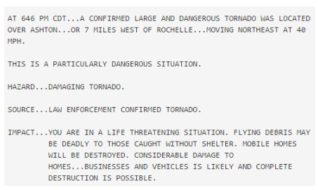
Now, all warnings are relayed almost instantaneously via satellite communications, and eleven NOAA Weather Radio transmitters across northern Illinois and northwest Indiana provide coverage to nearly 100 percent of the population. Radio broadcasts contain coded information that can trigger radios for specific types of alerts for specific counties. Tornado warnings, such as those issued for the devastating tornadoes that impacted Rochelle and Fairdale, Illinois on April 9, 2015, distinguish between tornadoes that are “Radar indicated”, “Radar confirmed”, “spotter confirmed” or “law enforcement confirmed”, include cities and other locations in the path and the estimated time they will be impacted, and uses strategic wording to convey the damage potential, from “Considerable” to “Catastrophic”. An example from April 9th, 2015 is shown below.
 |
|
Text of Rochelle Area Tornado Warning from April 9, 2015 |
Communication methods, frequency and availability have changed dramatically.
In 1990, the slow process of reporting and relaying information was sometimes not enough, and unfortunately for some the warnings came too late.
Now, in addition to radio and television, a plethora of methods of communication have emerged that allow for a redundancy in communication that reaches as many people as possible.
The NWS has a much closer and more effective relationship with county and community emergency management.
To help warn large groups of people more quickly, the Department of Homeland Security, Department of Education, and NOAA have teamed up to provide weather radios to every school in the country.
With the significant advancements in mobile technology, a large percentage of the population can receive and communicate warnings instantly by cell phone or other mobile device. The WEA (Wireless Emergency Alerts) system, a joint cooperation by the FCC and FEMA, now pushes Tornado and considerable Flash Flood Warnings straight to cellular devices no matter their volume or notification settings.
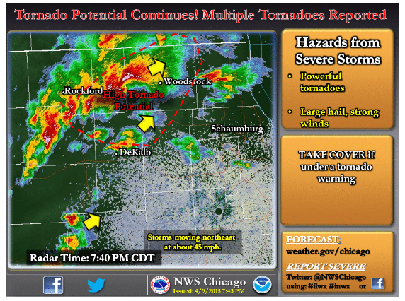
Online social networks such as Facebook and Twitter ensure warnings reach hundreds or thousands of people in minutes not to mention serves as a growing source of ground truth of the impact a storm is having. In addition to satellite, radio, cellular and internet feeds, NWS Chicago has made extensive use of social media, such as Facebook and Twitter, to convey high severe weather potential.
 |
|
Example of Social Media Post during the April 9, 2015 violent tornado event that struck Fairdale, IL. |
Changes in Radar Monitoring Over the Last 30 Years
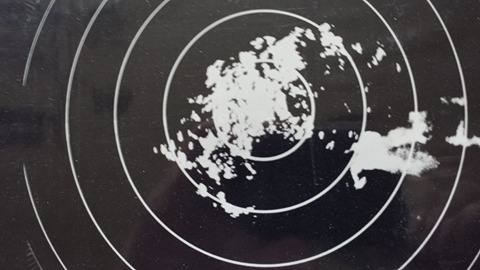
Much has changed with the National Weather Service’s radar program since the Plainfield Tornado. Throughout the 1990s, the network of 128 WSR-57 and WSR-74 radars (WSR stands for “Weather Surveillance Radars”) were replaced by the WSR-88D as part of the NWS “Modernization”. This is the doppler radar that’s still in use today at National Weather Service forecast offices, with the associated fleet of 159 S-band radars making up the Next-Generation Radar (NEXRAD) network.
 |
|
Example of WSR-57 radar image from Nashville in 1971. |
Radar Upgrades
Since its initial installation at WFO Chicago, our radar has undergone a series of additional upgrades as advances in radar meteorology have allowed us to continually improve our remote sensing capabilities. This includes improvements in post-processing techniques used to translate the “raw” radar signals into the data we’re used to seeing on computer and television displays, to physical hardware changes which took place towards the end of 2011 as part of the nationwide Dual Polarization upgrade. New radar products such as correlation coefficient and differential reflectivity allow us to distinguish between rain, hail, ice, snow and other material, and in some cases can serve as an alert that a tornado is on the ground by detecting debris!
Radar Resolution: Advances in signal processing--the conversion of the electronic signals received by the radar into data displays such as the one below--have allowed us to greatly increase the resolution of the WSR-88D, even without any physical alterations to the radar itself. This has resulted in an 8-fold increase in the data available for storm interrogation!
|
Digitized WSR-74 image from 8/28/1990 compared to legacy and super resolution imagery from the WSR-88D. |
Better Radar Scanning Strategies
A new scanning strategy known as SAILS (Supplemental Adaptive Intra-Volume Low-Level Scan) allows our radar to make repeated scans at the lowest elevation within an individual volume scan. Depending on the scanning strategy employed, this results in low-level updates as frequently as every 60 to 90 seconds, compared to every 5-6 minutes during the 1990s and early 2000s. A further addition was rolled out in 2020, allowing us to make repeated scans in the low AND mid-levels of thunderstorms to better sample developing rotation, for example.
Preparedness
Bottom Line: Is Chicago Prepared?
Despite the advances in science, technology, communications, and education, the Chicago metro area remains vulnerable to significant and potentially devastating severe weather events.
The Plainfield Tornado was 30 years ago. There has not been a violent F4/EF4 or F5/EF5 tornado in the Chicago metro area since 1990 (list of significant tornadoes in the Chicago metro). That means an entire generation of citizens has never experienced a major tornado in the metro area. Many people have moved to northeast Illinois and northwest Indiana from other parts of the country, or other parts of the world, and may not be familiar with Chicago’s history of violent tornadoes. Many people still believe the myths that tornadoes can’t hit urban areas or will be stopped by the cool water of Lake Michigan.
The truth is tornadoes have occurred in the heart of other major cities in just the past 10-15 years, including Atlanta, Fort Worth, Salt Lake City, Nashville, St. Louis, and Miami, as well as other large communities such as Joplin and Tuscaloosa. Tornadoes have struck within the city limits of Chicago in the past, including as recently as August 10th when an EF1 tornado tracked through the Rogers Park neighborhood of Chicago before moving out over Lake Michigan.
Despite the high speed communications available, many people still rely on tornado sirens – which are designated as outdoor warning systems and not meant to be heard indoors. Also, as the population of the metro area grows and spreads further out, more people are in harm’s way. The truth is that large violent tornadoes have struck the Chicago metro area in the past, and they will again. It is only a matter of time. We now have the tools, the communications, and the partnerships with emergency management and the media to effectively warn people when the big one strikes.
Even with all of the advances in the severe thunderstorm and tornado warning process and the abundant communication resources available today, people still need to take personal responsibility to plan, practice, monitor and act.
 |
|
|
| Click here for a multi-page PDF document. | ||
Plan: Develop a plan for your circumstances (home, school, ball park, business, etc)
Practice: Run through your plan periodically, like a fire drill
Monitor: If there is a risk of severe weather, monitor the weather!
Act: Be proactive, if threatening weather approaches or warnings are issued, activate your plan.
Links
 |
Page assembled by numerous NWS Chicago staff including past work by Jim Allsopp (ret. NWS), and former students Nicole Batzek and Cameron Nixon. Media use of NWS Web News Stories is encouraged! |
 |