
If you are looking for fresh snow by Christmas morning or are curious about potential travel disruptions, the best chances for at least 1" of new snowfall early this week exist across the mountainous West, Great Lakes, and Northeast. Otherwise, temperatures this last full week of December will average above normal for much of the lower 48 states. Read More >
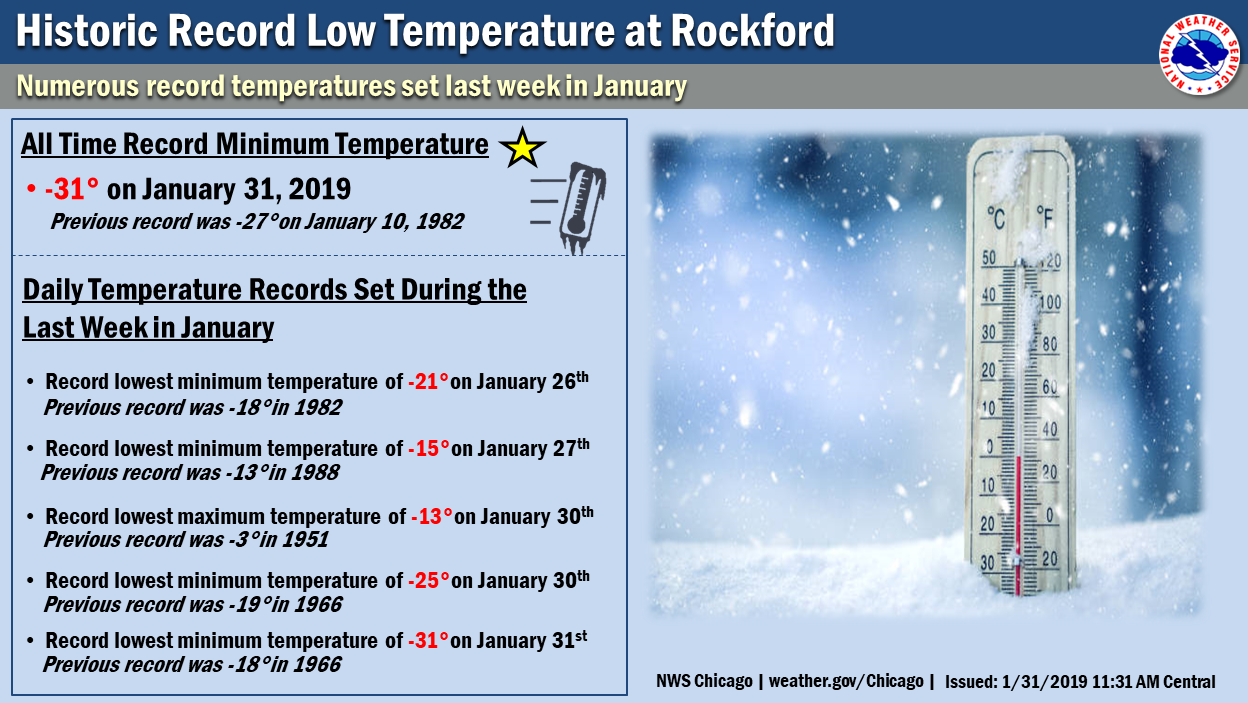
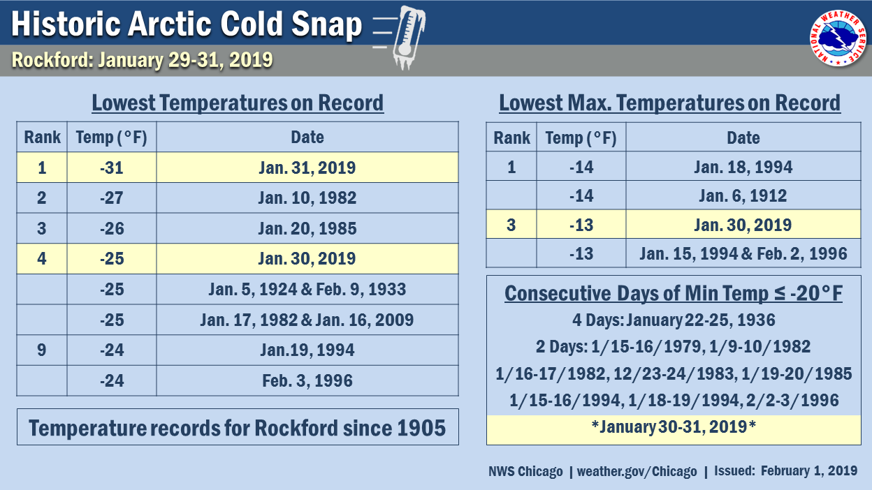
| The coldest temperature in Chicago in 34 years (-23°) was recorded on the morning of January 30, 2019 during a bitter cold couple of days. Rockford, IL broke their all-time record cold temperature with a low of -31° on January 31. Highs on January 30 were recorded at midnight as temperatures were plummeting, and these "highs" were only in the negative double digits. | 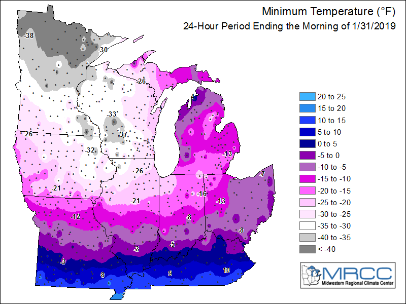 |
Fast Facts
Record Temperatures
 |
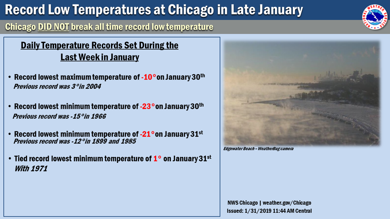 |
| Record temperatures at Rockford | Record temperatures at Chicago |
 |
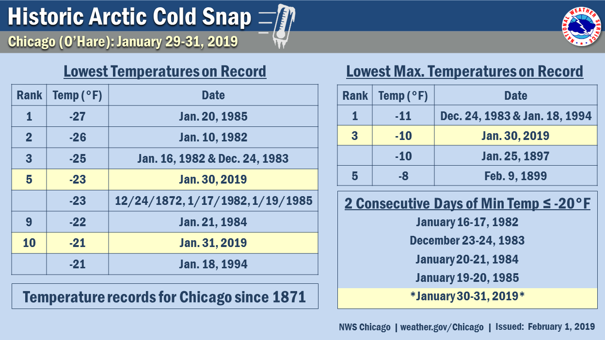 |
|
Coldest Days on Record in Rockford |
Coldest Days on Record in Chicago |
|
Duration of Subzero Temps at Rockford |
Duration of Subzero Temps at Chicago |
|
Jan. 5-7, 2014 vs. Jan. 29-31, 2019 in Rockford |
Jan. 5-7, 2014 vs. Jan. 29-31, 2019 in Chicago |
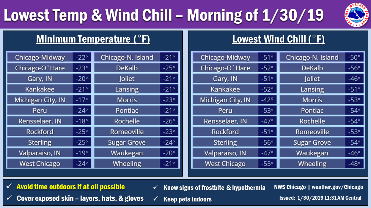
Public Information Statement National Weather Service Chicago IL 1006 AM CST Thu Jan 31 2019 ...48 HOUR LOW TEMPERATURE REPORTS... Location Temp Time/Date Provider Rank Sugar Grove - Aurora Arpt. -32 F 0552 AM 01/31 ASOS Rochelle Airport -31 F 0715 AM 01/31 AWOS Rockford Airport -31 F 0714 AM 01/31 ASOS NEW RECORD Rochelle -30 F 0600 AM 01/31 COOP 2nd Coldest West Chicago - DuPage Arpt. -29 F 0552 AM 01/31 ASOS Barrington -28 F 0800 AM 01/31 COOP NEW RECORD Paw Paw 2S -27 F 0700 AM 01/30 COOP 4th Coldest Mundelein 4 WSW -26 F 0700 AM 01/31 COOP NEW RECORD Ottawa - Buffalo Rock SP -26 F 0845 AM 01/30 COOP DeKalb -26 F 0700 AM 01/31 COOP 2nd Coldest McHenry Lock and Dam -26 F 0800 AM 01/30 COOP 2nd Coldest Aurora -25 F 0700 AM 01/31 COOP 2nd Coldest Batavia -25 F 0600 AM 01/31 COOP DeKalb Airport -25 F 0635 AM 01/31 AWOS Elgin -25 F 0700 AM 01/31 COOP 2nd Coldest Lansing Airport -24 F 0715 AM 01/31 AWOS Peru Airport -24 F 0755 AM 01/30 AWOS Morris Airport -23 F 0815 AM 01/30 AWOS Morris 1NW -23 F 0800 AM 01/30 COOP 2nd Coldest Joliet Airport -23 F 0355 AM 01/31 AWOS Romeoville - Lewis Airport -23 F 0815 AM 01/30 AWOS Romeoville - NWS Chicago -23 F 1200 AM 01/31 NWS 2nd Coldest Chicago OHare -23 F 0751 AM 01/30 ASOS 5th Coldest Waukegan Airport -23 F 0655 AM 01/31 ASOS Waukegan Harbor -23 F 0840 AM 01/30 NWS-GLOS Park Forest -23 F 0800 AM 01/31 COOP 3rd Coldest Dwight -22 F 0700 AM 01/31 COOP NEW RECORD Chicago Midway -22 F 1153 AM 01/30 ASOS Midway 3 SW COOP -22 F 0600 AM 01/31 COOP 2nd Coldest Morris 1 NW -22 F 0800 AM 01/31 COOP Joliet Lock and Dam -22 F 0600 AM 01/31 COOP 4th Coldest Kankakee Waste Water -22 F 0700 AM 01/30 COOP 5th Coldest Kankakee Airport -21 F 0755 AM 01/30 AWOS Pontiac Airport -21 F 0815 AM 01/30 AWOS Wheeling - Chicago Exec. Arp -21 F 0852 AM 01/30 ASOS Paxton 2WSW -21 F 0630 AM 01/31 COOP 3rd Coldest Marseilles Lock and Dam -21 F 0600 AM 01/30 COOP 5th Coldest Chicago Crib -20 F 0910 AM 01/30 MARITIME Gary Airport -20 F 1045 AM 01/30 AWOS Rensselaer -20 F 0730 AM 01/31 COOP Streator -20 F 0700 AM 01/31 COOP 2 NW Watseka -20 F 0700 AM 01/31 COOP Michigan City C-man -19 F 0710 AM 01/31 MARITIME Valparaiso Airport -19 F 0656 AM 01/30 ASOS Rensselaer Airport -18 F 0855 AM 01/30 AWOS Observations are collected from a variety of sources with varying equipment and exposures. We thank all volunteer weather observers for their dedication. Not all data listed are considered official. $$ |
Wind Chill
 |
 |
| Lowest Temperatures and Wind Chills January 30th | Lowest Temperatures and Wind Chills January 31st |
PNSLOT ILZ003>006-008-010>014-019>023-032-033-039-INZ001-002-010-011-019-310728- Public Information Statement National Weather Service Chicago IL 128 PM CST Wed Jan 30 2019 ...Minimum Observed Wind Chill Values... The following is a list of minimum observed wind chill values for the morning of Wednesday, January 30th, 2019. Location Temp Time/Date DeKalb Airport -56 F 0755 AM 01/30 West Chicago - DuPage Arpt. -55 F 0752 AM 01/30 Pontiac Airport -54 F 0635 AM 01/30 Rochelle Airport -54 F 0715 AM 01/30 Sugar Grove - Aurora Arpt. -54 F 0852 AM 01/30 Morris Airport -53 F 0515 AM 01/30 Romeoville - Lewis Airport -53 F 0735 AM 01/30 Peru Airport -53 F 0835 AM 01/30 Chicago OHare -52 F 0651 AM 01/30 Kankakee Airport -52 F 0755 AM 01/30 Chicago Midway -51 F 0653 AM 01/30 Rockford Airport -51 F 0654 AM 01/30 Lansing Airport -51 F 0855 AM 01/30 Gary Airport -51 F 0945 AM 01/30 Chicago - Northerly Island -50 F 0630 AM 01/30 Wilmington - Midewin RAWS -48 F 0805 AM 01/30 Wheeling - Chicago Exec. Arp -48 F 0852 AM 01/30 Rensselaer Airport -47 F 0555 AM 01/30 Valparaiso Airport -47 F 0656 AM 01/30 Joliet Airport -46 F 0715 AM 01/30 Waukegan Airport -46 F 0755 AM 01/30 Observations are collected from a variety of sources with varying equipment and exposures. We thank all volunteer weather observers for their dedication. Not all data listed are considered official. $$ Kluber |
Science
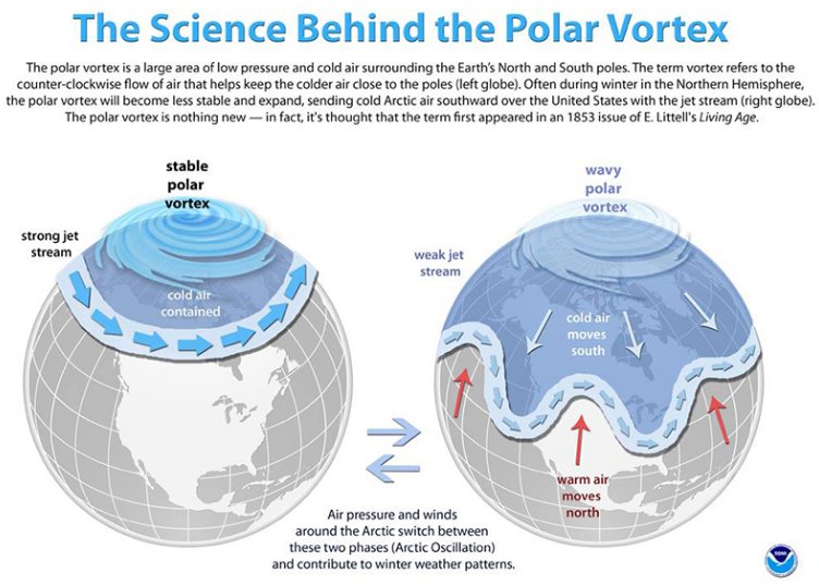 |
| Science behind the polar vortex. |
| One of the primary satellite channels we use detects clouds by measuring the temperature being emitted from Earth. Clouds generally emit temperatures colder than at the surface because the air temperature typically drops the higher up you get in the atmosphere. January 30-31 were so cold that the temperatures at the surface were as cold as cloud typically are well above the ground. This satellite image shows the very cold temperatures over the region early on the morning of January 31st. Interestingly, features like Chicago and Rockford's urban heat islands stand out as "warm" spots on this image! |  |
Additional
Photos
 |
 |
 |
| Photo courtesy of Stephen Rodriguez Bolingbrook, IL |
Photo courtesy of Joey Marino Rockford, IL |
Photo courtesy of Noah Liebman Lakeview Chicago |
 |
 |
 |
| Photo courtesy of Barry Butler Chicago, IL |
Photo courtesy of Michael Lyons West Loop Chicago |
Photo courtesy of Gina Kietzmann Fox River at Algonquin Tailwater |
Links
 |
Media use of NWS Web News Stories is encouraged! Additional recaps can be found on the NWS Chicago Science & Past Events Page. |
 |