| Sanborn Field - Columbia | ||
41°F | ||
| Humidity | 59% | |
| Wind Speed | 4.8 mph | |
| Wind Dir. | SSW | |
| Pressure |  | |
| 35.4°F | ||
| Rainfall | 0.00 in. | |
September 2024 Weather and Its Impacts on Missouri
Dr. Pat Guinan |
Dr. Zachary Leasor |
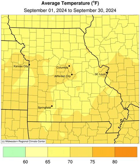
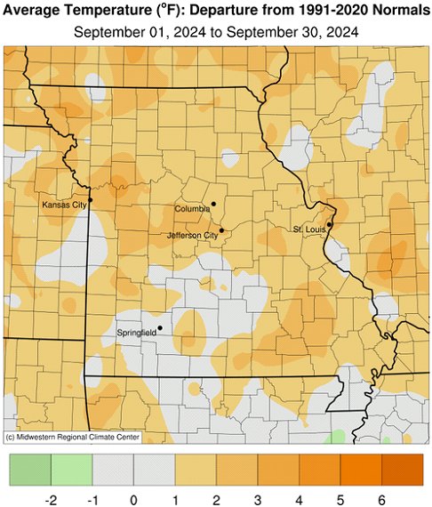
Seasonably cool weather dominated Missouri during the first third of September followed by mostly near to above average temperatures for the rest of the month, Figure 1. Preliminary data indicate a statewide average temperature of 69.4 °F, or 1.7 degrees above the long-term average. The month followed the trend over the past decade with 9 out of the past 10 Septembers warmer than average, Figure 2. Six out of the past nine months have been above average, Figure 3.
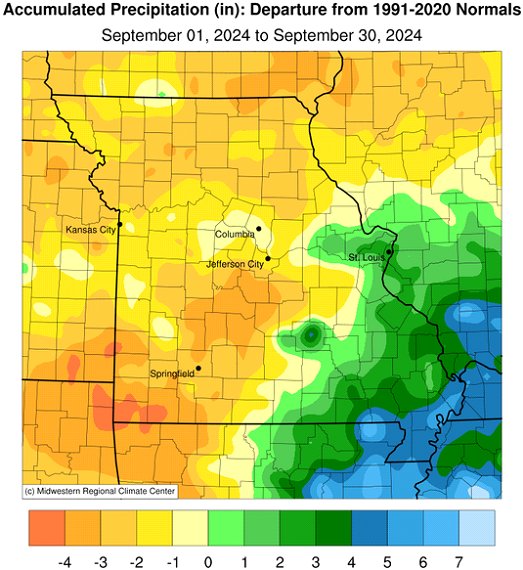
Except for extreme east central and southeastern Missouri, below average rainfall impacted the rest of the state. Preliminary data indicated a statewide average of 3.01 inches, 1.09 inches below the long-term average. It was the eighth consecutive dry September for the state and 9 out of the past 10 Septembers have been drier than average, Figure 4. It was the fourth month this year with below average precipitation, Figure 5.
September rainfall was variable across Missouri with radar-estimates indicating highest amounts over southeastern Missouri and driest conditions in southwestern sections and a small pocket in south central Missouri, Figure 6. The remnants of Hurricane Francine on September 12-13 contributed notably to the Bootheel region with widespread reports of 1-3 inches. Some of the heaviest and lightest rainfall reports for September are listed in Table 1.
| Missouri High and Low Rainfall Extremes for September 2024* | |||
| Station Name* | County | Rainfall (in.) | |
| Heaviest | |||
| Salem 3.5E | Dent | 10.17 | |
| New Madrid 0.2SE | New Madrid | 9.09 | |
| Anniston 1.9WNW | Mississippi | 8.76 | |
| Oak Ridge 1.5WSW | Cape Girardeau | 8.49 | |
| Dexter 2.3W | Stoddard | 8.16 | |
| Licking 4N | Texas | 7.75 | |
| St. Charles 7SSW | St. Charles | 7.68 | |
| Lightest | |||
| Anderson 4.2W | McDonald | 0.24 | |
| Cassville 0.5SW | Barry | 0.28 | |
| Lebanon 0.6N | Laclede | 0.40 | |
| Dixon 5.2NE | Maries | 0.43 | |
| Neosho | Newton | 0.48 | |
| Iberia | Miller | 0.51 | |
| Branson Airport | Taney | 0.57 | |
| *Rain gauges are from the NWS Cooperative Network and CoCoRaHS observations. | |||
| Table 1. | |||
The U.S. Drought Monitor for October 1, 2024, showed far west central and southwestern Missouri experiencing moderate to severe drought, Figure 7. Sizeable portions of northeastern and central Missouri were abnormally dry. Dryness impacts continued to mount, mostly across southwestern Missouri. There have been reports of vegetative stress, including crop and pasture losses, trees dying, and dwindling feed and water supplies, Figures 8-14. There was little to no opportunity for renewed grass growth for pastures and lawns in drier areas. Seeding efforts for cool season turfgrasses were also hampered.
According to the Missouri Agricultural Statistics Service, as of September 29, 2024, most of the corn was in good to excellent condition at 61% and 23%, respectively. Remaining corn conditions this year were 11% fair, 3% poor and 2% very poor. Corn harvest was running ahead of schedule at 48%, compared to the 5-year average of 31%. Most of the soybean crop this year was reported in good (57%) to fair (22%) condition with 13% reported as excellent. Remaining soybean conditions were 6% poor and 2% very poor. Last year, at this time, soybean was 5% very poor, 14% poor, 33% fair, 43% good and 5% excellent.
Hay and roughages were 76% adequate with 19% surplus this year and 5% short and 0% very short. Stock water supplies were mostly adequate at 86%, with 10% short, 2% very short and 2% surplus. Pastures were reported 2% excellent, 43% good, 41% fair, 11% poor, and 3% very poor condition.
Topsoil moisture conditions were 3% surplus, 69% adequate, 23% short and 5% very short. The subsoil moisture conditions were reported 1% surplus, 66% adequate, 26% short, and 7% very short.
Most sections of the Missouri will experience their first fall frost during October, Figure 15. Using climatology, the northern quarter of Missouri and eastern Ozarks will generally experience a light freeze (32°F or cooler) by mid-October. Central Missouri and the western Ozarks will experience a light freeze by October 21st, and a few days later in urban areas. The Bootheel will have a light freeze typically toward the end of October or early November. For more information on frost/freeze probabilities for Missouri, including additional temperature thresholds, please visit the following link: http://ipm.missouri.edu/FrostFreezeGuide.
Jump to:
- Figure 1
- Figure 2
- Figure 3
- Figure 4
- Figure 5
- Figure 6
- Figure 7
- Figure 8
- Figure 9
- Figure 10
- Figure 11
- Figure 12
- Figure 13
- Figure 14
- Figure 15
- Figure 16
- Figure 17
- Figure 18
- Figure 19

Figure 1.
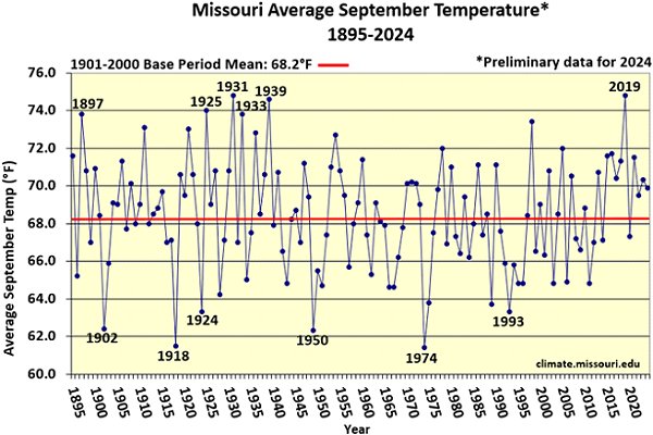
Figure 2.
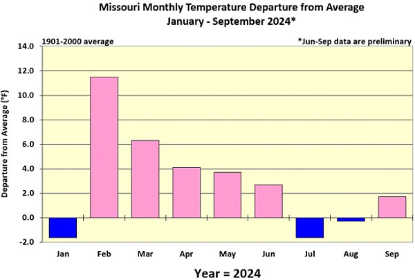
Figure 3.

Figure 4.

Figure 5.
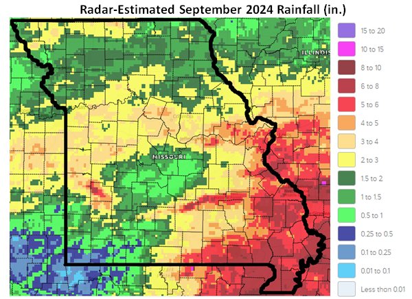
Figure 6.
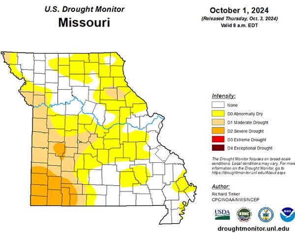
Figure 7.

Figure 8. St. Clair County, Sep. 20, 2024

Figure 9. McDonald County, Sep. 20, 2024

Figure 10. Newton County, Sep. 21, 2024

Figure 11. Dade County, Sep. 24, 2024

Figure 12. Vernon County, Sep. 24, 2024

Figure 13. Barry County Sep. 30, 2024

Figure 14. Webster County, September 30, 2024

Figure 15.

Source: Dr. Pat Guinan and Dr. Zack Leasor | 573-882-5908


