Overview
|
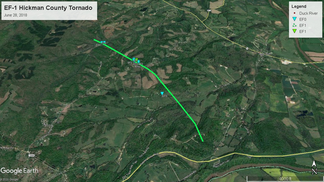
The final and worst day in a week-long series of strong to severe thunderstorm events across Middle Tennessee struck the area during the morning and early afternoon hours on June 28. After overnight storms affected the northeast half of Middle Tennessee during the night, additional scattered strong to severe thunderstorms developed along the I-24 corridor between 7 AM to 9 AM CDT on Thursday morning June 28. These storms expanded in coverage and eventually congealed into three separate bow echoes, each of which produced severe downburst winds of 60 mph up to and over 80 mph in some areas. These intense winds caused widespread damage across many southwest Middle Tennessee counties, with Hickman and Marshall Counties particularly hard hit. One EF1 tornado also briefly touched down in Hickman County. |
 EF-1 tornado damage near Duck River, TN |
Tornadoes:
|
EF-1 Tornado - Duck River, TN
Track Map   |
||||||||||||||||
The Enhanced Fujita (EF) Scale classifies tornadoes into the following categories:
| EF0 Weak 65-85 mph |
EF1 Moderate 86-110 mph |
EF2 Significant 111-135 mph |
EF3 Severe 136-165 mph |
EF4 Extreme 166-200 mph |
EF5 Catastrophic 200+ mph |
 |
|||||
Storm Reports
PRELIMINARY LOCAL STORM REPORT...SUMMARY
NATIONAL WEATHER SERVICE NASHVILLE TN
339 PM CDT THU JUN 28 2018

..TIME...   ...EVENT...      ...CITY LOCATION...     ...LAT.LON...
..DATE...   ....MAG....      ..COUNTY LOCATION..ST.. ...SOURCE....
            ..REMARKS..

0551 AM     TSTM WND DMG     7 SE BYRDSTOWN          36.49N  85.06W
06/28/2018                   FENTRESS           TN   EMERGENCY MNGR

            TREES DOWN IN THE DOUBLE TOP AREA.

0605 AM     TSTM WND DMG     1 N ALLARDT             36.40N  84.88W
06/28/2018                   FENTRESS           TN   EMERGENCY MNGR

            TREES DOWN ON GOVERNMENT POND RD.

0730 AM     FLASH FLOOD      JAMESTOWN               36.43N  84.94W
06/28/2018                   FENTRESS           TN   EMERGENCY MNGR

            MULTIPLE ROADS WERE FLOODED AND CLOSED IN THE JAMESTOWN
            AREA.

1038 AM     TSTM WND DMG     SPRING HILL             35.74N  86.92W
06/28/2018                   MAURY              TN   EMERGENCY MNGR

            MULTIPLE REPORTS OF TREES DOWN IN SPRING HILL INCLUDING
            A TREE ON A HOUSE ON NEELY'S BEND.

1038 AM     TSTM WND DMG     SPRING HILL             35.74N  86.92W
06/28/2018                   MAURY              TN   EMERGENCY MNGR

            UPDATE FROM EARLIER LSR... A TREE FELL THROUGH ONE
            HOUSE ON NEELY'S BEND LEAVING IT UNINHABITABLE. ANOTHER
            HOUSE ON NEELY'S BEND HAD A LARGE BRANCH FALL ON IT
            CAUSING ROOF DAMAGE.

1101 AM     TSTM WND DMG     LEWISBURG               35.45N  86.79W
06/28/2018                   MARSHALL           TN   EMERGENCY MNGR

            THE FRONT OF AN AUTO PARTS STORE WAS RIPPED OFF.

1104 AM     TSTM WND DMG     7 SSE ROVER             35.57N  86.57W
06/28/2018                   BEDFORD            TN   TRAINED SPOTTER

            TREE DAMAGE WAS REPORTED OFF OLD COLUMBIA RD IN
            UNIONVILLE.

1104 AM     TSTM WND DMG     LEWISBURG               35.45N  86.79W
06/28/2018                   MARSHALL           TN   EMERGENCY MNGR

            SEVERAL REPORTS OF TREES DOWN IN LEWISBURG.

1203 PM     TSTM WND DMG     LYNNVILLE               35.38N  87.01W
06/28/2018                   GILES              TN   EMERGENCY MNGR

            TREES DOWN IN LYNNVILLE.

1205 PM     TSTM WND DMG     DOVER                   36.48N  87.84W
06/28/2018                   STEWART            TN   EMERGENCY MNGR

            EMERGENCY MANAGER REPORTED TREES DOWN COUNTY WIDE.

1212 PM     TSTM WND DMG     8 SW DICKSON            35.99N  87.48W
06/28/2018                   DICKSON            TN   LAW ENFORCEMENT

            TREES DOWN NEAR CAMP GARNERS CREEK ON GARNERS CREEK
            ROAD.

1222 PM     TSTM WND DMG     NUNNELLY                35.86N  87.47W
06/28/2018                   HICKMAN            TN   EMERGENCY MNGR

            TREES DOWN COUNTY WIDE IN HICKMAN COUNTY.

1226 PM     TSTM WND DMG     DICKSON                 36.08N  87.38W
06/28/2018                   DICKSON            TN   EMERGENCY MNGR

            TREES DOWN IN DICKSON COUNTY

1230 PM     TSTM WND DMG     2 S DICKSON             36.05N  87.38W
06/28/2018                   DICKSON            TN   TRAINED SPOTTER

            A DOWNED TREE WAS FULLY BLOCKING COWAN RD NEAR REIDLAND
            DR.

1230 PM     TSTM WND DMG     4 WNW CENTERVILLE       35.82N  87.52W
06/28/2018                   HICKMAN            TN   EMERGENCY MNGR

            TREES DOWN AND POWER OUTAGES REPORTED.

1235 PM     TSTM WND DMG     6 WNW WILLIAMSPORT      35.72N  87.31W
06/28/2018                   HICKMAN            TN   EMERGENCY MNGR

            ONE HOUSE ON MOBLEY RIDGE RD SUSTAINED WIND DAMAGE.

1238 PM     TSTM WND DMG     2 E CENTERVILLE         35.79N  87.41W
06/28/2018                   HICKMAN            TN   EMERGENCY MNGR

            TREE REPORTED DOWN ON THE POWER LINES AT MORRISON
            STREET.

1245 PM     TSTM WND DMG     LOBELVILLE              35.75N  87.80W
06/28/2018                   PERRY              TN   EMERGENCY MNGR

            NUMEROUS TREES DOWN IN NORTHERN PERRY COUNTY.

1253 PM     TSTM WND DMG     4 W MOUNT PLEASANT      35.55N  87.26W
06/28/2018                   MAURY              TN   EMERGENCY MNGR

            TREES DOWN ON SOUTH FORK RD.

1253 PM     TSTM WND DMG     MOUNT PLEASANT          35.55N  87.19W
06/28/2018                   MAURY              TN   EMERGENCY MNGR

            TREES DOWN IN THE MOUNT PLEASANT AREA.

0103 PM     TSTM WND DMG     7 SSE MOUNT PLEASANT    35.46N  87.14W
06/28/2018                   MAURY              TN   EMERGENCY MNGR

            NUMEROUS TREES AND POWER LINES DOWN AROUND THE
            INTERSECTION OF ELK RIDGE ROAD AND ENTERPRISE ROAD.

0111 PM     TSTM WND DMG     ETHRIDGE                35.32N  87.30W
06/28/2018                   LAWRENCE           TN   EMERGENCY MNGR

            A TREE SNAPPED AND FELL ON POWER LINES.

0119 PM     TSTM WND DMG     4 ESE LAWRENCEBURG      35.22N  87.27W
06/28/2018                   LAWRENCE           TN   FIRE DEPT/RESCUE

            NEW PROSPECT FIRE REPORTED SEVERAL TREES DOWN FROM
            LAWRENCEBURG EAST TO THE COUNTY LINE.

0125 PM     TSTM WND DMG     PULASKI                 35.20N  87.03W
06/28/2018                   GILES              TN   EMERGENCY MNGR

            SEVERAL REPORTS OF TREES DOWN IN PULASKI.

0127 PM     TSTM WND DMG     6 SW PULASKI            35.13N  87.11W
06/28/2018                   GILES              TN   EMERGENCY MNGR

            TREES DOWN IN ANTHONY HILL.

0130 PM     FLASH FLOOD      DICKSON                 36.08N  87.38W
06/28/2018                   DICKSON            TN   EMERGENCY MNGR

            SEVERAL ROADS FLOODED IN THE DICKSON AND BURNS AREA.
            WATER IS BEGINNING TO RECEDE.

0158 PM     HAIL             3 W LAWRENCEBURG        35.25N  87.39W
06/28/2018  E0.88 INCH       LAWRENCE           TN   EMERGENCY MNGR

            NICKEL SIZE HAIL FELL ON GRANDADDY RD.

0158 PM     FLASH FLOOD      COLUMBIA                35.62N  87.05W
06/28/2018                   MAURY              TN   SOCIAL MEDIA

            SEVERAL ROADS COVERED IN WATER IN COLUMBIA.
 |
Media use of NWS Web News Stories is encouraged! Please acknowledge the NWS as the source of any news information accessed from this site. |
 |