Gaging an Underwater Waterfall
Dear AGU,
Ground water venting from sublacustrine karst sinkholes in the Laurentian Great Lakes has unique properties: high dissolved salt (including sulfate) from wafting through Paleozoic marine evaporites, low oxygen...

Gaging an Underwater Waterfall

Dear AGU,  

Ground water venting from sublacustrine karst sinkholes in the Laurentian Great Lakes has unique properties: high dissolved salt (including sulfate) from wafting through Paleozoic marine evaporites, low oxygen due to microbial respiration during the long sub-terranean transit, and a low and steady millennium-average aboveground temperature of ~9oC. At the Middle Island Sinkhole (Lake Huron), groundwater that is denser than the overlying lake water fills the bottom of a ~23 m deep, 10 m wide bowl-shaped nearshore sinkhole. It then spills over the bowl’s sill at ~14 m into the amphitheater-like wider lake floor that is at ~ 25 m – a vertical drop of ~9 m – as an underwater waterfall! Here, the high-sulfur, low-oxygen waterfall – whose flow rate is yet to be quantified – nurtures a dynamic photo- and chemosynthetic microbial mat world. 

            To deepen our understanding of this underwater waterfall (other than the fun fact that divers could have fun sliding down the fall), we deployed 2 tilt-meters (Lowell Instruments TCM-1) equipped with a 3-axis accelerometer + magnetometer for continuously logging flow rate and direction: one at the edge of the sill and the other in the middle of the fall (inset) – already leaning in the direction of flow. Wonder what secrets the time-series data will reveal when we retrieve the tilt-meters next year: Is the flow steady or erratic? Do peak flows coincide with overland precipitation events? Are flow rate and mat growth in synch? How vulnerable are mat ecosystems to the vagaries of groundwater flux as the climate overhead changes?

— Phil Hartmeyer, NOAA-Ocean Exploration; Cassandra Sadler, Andi Yoxsimer, NOAA-Thunder Bay National Marine Sanctuary; Steve Ruberg, NOAA-Great Lakes Environmental Research Laboratory; Bopi Biddanda, GVSU-Annis Water Resources Institute, Michigan.

postcards from the field

Harnessing Mountain Water Towers: Mail from Machu Picchu
Dear AGU,
The first thing that impresses those who trek up to the ruins of Machu Picchu – other than the spectacularly biodiverse transition landscape between the Peruvian Andes and the Amazon...

Harnessing Mountain Water Towers: Mail from Machu Picchu

Dear AGU,

The first thing that impresses those who trek up to the ruins of Machu Picchu – other than the spectacularly biodiverse transition landscape between the Peruvian Andes and the Amazon Basin – is that you are not really on top of the world. Machu Picchu (Old Mountain, in Quechua), located at ~3,000 m above mean sea level, is itself surrounded by towering mountains that rise to ~4,000 above msl. Over 600 years ago, the Inca harnessed natural springs originating at higher elevations to supply water to their homes and irrigate their terraced fields here in this mountain-top sanctuary. In these images from July 2024, one can see evidence of canals crisscrossing the ruins that eventually drain to the Urubamba River in the Sacred Valley below. Evidence of active aqueducts, fountains and irrigation canals can be also seen in the nearby Inca villages that have been continuously inhabited over the past several centuries. One good example of such indigenous hydroengineering lies in the village of Ollantaytambo that has water derived from Andean glaciers perennially running through it. 

World over, people have utilized mountain water towers as a source of water for millenia taking advantage of the power of the water cycle to raise water, the capacity of mountains to store it, and force of gravity to release it – maintaining fertile landscapes of running fresh water. The Romans and Moors have left lasting legacies of their extensive network of aqueducts and canals throughout the Mediterranean – some of which are still functional. 

Today, roughly half of humanity depends on water derived from rapidly dwindling mountain water towers – many of them still glaciated or periglaciated. With anthropogenic land-use changes in mountain habitats altering their capacity to hold and release water, and ongoing global warming accelerating glacial mass loss, water security will get precarious over time. The world’s mountain water towers need immediate protection from the multi-pronged threats eroding their unique water-holding capacity. 

— Bopi Biddanda, Annis Water Resources Institute, Grand Valley State University, Muskegon, Mich. (www.gvsu.edu/wri/)

postcards from the field

A Metazoan Visitor in a Microbial World
Dear AGU,
Life in submerged karst sinkholes in the Laurentian Great Lakes, where salty groundwater with high-sulfur and low-oxygen is actively venting, is almost exclusively composed of prokaryotic microbes,...

A Metazoan Visitor in a Microbial World

Dear AGU,  

Life in submerged karst sinkholes in the Laurentian Great Lakes, where salty groundwater with high-sulfur and low-oxygen is actively venting, is almost exclusively composed of prokaryotic microbes, Bacteria and Archaea, that build colorful benthic mats capable of both photosynthesis and chemosynthesis. Aerobic organisms such as eukaryotic invertebrates and vertebrates are usually excluded from these isolated underwater benthic habitats (ranging anywhere in size from a room to a football field) due to the prevailing low-oxygen conditions.  

Exceptions abound though. Diver-collected mats and observations from the fringes of these ecosystems, where the groundwater’s influence is diluted by mixing with well-oxygenated lake water, often reveal a host of eukaryotic protists (e.g., diatoms) and low-oxygen-tolerant invertebrates (e.g., nematodes and tardigrades), and even small vertebrate fish (e.g., gobies). However, it is quite uncommon to find larger mobile fish, such as this Burbot (Lota lota, a member of the Cod family, native to inland waters of North America), in the center of the sinkhole in low-oxygen groundwater. Like human divers, fish may be transient metazoan visitors to this otherworldly microbial world. Modern-day sinkholes with actively venting high-salt, high-sulfur, low-oxygen groundwater remain microbial refugia – providing a glimpse into life’s early salty, sulfurous and anoxic microbial origins.

– Jon Slayer, Force Blue (https://forceblueteam.org); Stephanie Gandulla, NOAA-Thunder Bay National Marine Sanctuary (www.thunderbay.noaa.gov); Steve Ruberg, NOAA-Great Lakes Environmental Research Lab (https://www.glerl.noaa.gov/); and Bopi Biddanda, GVSU-Annis Water Resources Institute, (www.gvsu.edu/wri/).

postcards from the field

Summer Blooms Trouble Great Lakes Estuaries
Dear AGU,
A cocktail of blooms made up of potentially toxin-producing cyanobacteria (Microcystis sp. and Dolichospermum sp.) has now proliferated for over 2 weeks in Muskegon Lake, Michigan – a Great Lakes...

Summer Blooms Trouble Great Lakes Estuaries

Dear AGU,

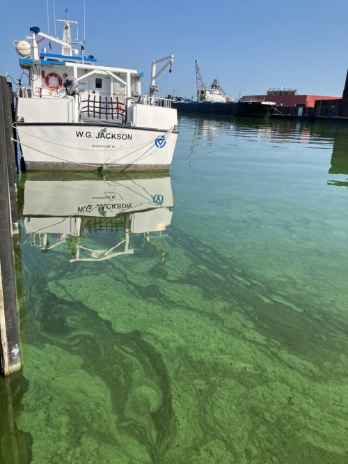
A cocktail of blooms made up of potentially toxin-producing cyanobacteria (Microcystis sp. and Dolichospermum sp.) has now proliferated for over 2 weeks in Muskegon Lake, Michigan – a Great Lakes estuary. Muskegon Lake is one of two dozen drowned river-mouth estuaries in West Michigan that flow into Lake Michigan – a Laurentian Great Lake. Because estuaries occur at the end of their watersheds, they integrate signals of climate change and anthropogenic perturbations from across their water and airsheds.

Water quality in Muskegon Lake has been improving for over a decade (as indicated by a time-series buoy observatory www.gvsu.edu/buoy/), and restoration measures resulting in reduced nutrient inputs from the watershed have been credited for the lake’s recovery. However, recent years (2021, 2022, and now 2024) have witnessed record-breaking blooms due to warmer waters initiating earlier spring onset and later fall overturn compounded by highly variable precipitation/river loading. This summer, there are reports of intense cyanobacterial blooms like those in Muskegon Lake coming from several adjacent coastal estuaries (e.g., Mona Lake in the South, and White Lake in the North) – suggesting this is a region-wide phenomenon and that current restoration efforts are inadequate to address the long-term impacts of ongoing change.

            Around the world, rivers, lakes and estuaries serve as vital water sources for humanity, biodiversity and ecosystem function. A warming climate and anthropogenic nutrient pollution coupled with more extreme hydrological cycles could turn these waters green and toxic – compromising ecosystem health, water quality, and overall quality of life.

— Bopi Biddanda, Connor Gabel, Nicole D’Arienzo, Dee Phillips, Kay Dennis, Anna Maki and Tony Weinke, Annis Water Resources Institute, Grand Valley State University, Muskegon, Mich. (www.gvsu.edu/wri/)

postcards from the field

Hello from Utqiagvik, Alaska in late February of 2024! This picture was taking during my year-long biennial Arctic Geophysics undergraduate research class. The students in this class choose their own research area dealing with the sea ice, and then I...

Hello from Utqiagvik, Alaska in late February of 2024! This picture was taking during my year-long biennial Arctic Geophysics undergraduate research class. The students in this class choose their own research area dealing with the sea ice, and then I work with them to build - to MacGyver! - their own microcontroller-based sensors to collect data to address their research question. Most students are there for one of two weeks, with half the class the first week and half the second. One or two of the students are there for both weeks, depending on their particular project. The trip is in late February/early March, when the sea ice is thickest.

This picture was taken one evening when the aurorae put on a particularly spectacular display. We were staying in a dormitory located off the northern end of the grounds of the former Naval Arctic Research Laboratory (NARL), which is itself just north of Utqiagvik. This had fewer street lights than the main NARL grounds, and afforded amazing views of these celestial fireworks. This picture shows one of my students on top of a snow/ice pile just behind (inland side of) the building, caught up in the moment of seeing this phenomenon. He had no idea that I was behind him for this picture, and I was fortunate to capture him howling with his rock hammer in his “hammer of the gods” moment. His unbridled joy is apparent at viewing our sun’s deadly particle stream being turned into these harmless and beautiful high-atmosphere light displays by a happy conspiracy of Earth’s magnetic field and atmosphere, and leaves an indelible impression. 

In addition to experiencing these bucket-list auroral marvels, my students get the chance to do research under difficult conditions in an extreme environment, so often surprising themselves at what they can accomplish. So many of them refer to this experience - both the research and living in that beautiful area - as “life-changing,” and I can honestly say the same thing myself.

Dr. Rhett Herman, Professor of Physics, Radford University, Radford, VA, USA.

AGU postcards from the field submission

What is the age of groundwater venting at submerged karst sinkholes?
Dear AGU,
Mysteries abound regarding ground water composition, inventories and fluxes. This is particularly true for the age of ground water venting from submarine and sublacustrine...

What is the age of groundwater venting at submerged karst sinkholes?

Dear AGU,  

Mysteries abound regarding ground water composition, inventories and fluxes. This is particularly true for the age of ground water venting from submarine and sublacustrine vents such as the submerged karst sinkholes in the Laurentian Great Lakes. Currently, we have no idea if the groundwater venting out of nearshore and offshore sinkholes in Lake Huron is days, years, centuries, or even many millennia old – even though this know-how is key to understanding aquifer recharge and turnover, assessing its contribution to lake levels and the potential for groundwater contamination and its transfer to the lake’s interior.

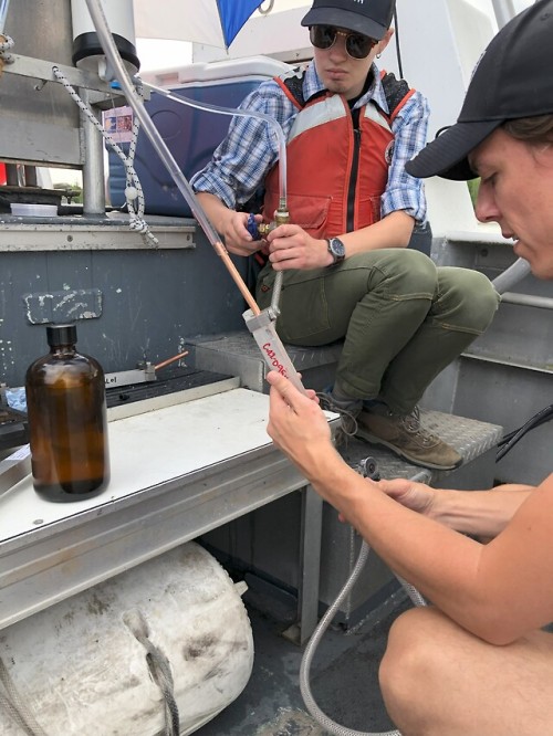
            Here onboard NOAA’s R/V Storm, divers have just brought up groundwater samples in airtight Van Dorn bottles from the bottom of Middle Island Sinkhole (~23 m depth). Working underneath the shade of an umbrella, research technician Tony Weinke and graduate student Cecilia Howard are carefully draining the groundwater samples into copper collection tubes that will be sealed without bubbles and exposure to atmosphere for sulfur hexafluoride (SF6) measurements. Since anthropogenic SF6 arose about 70 years ago, its presence or absence in venting groundwater will inform us if it is relatively young or quite old, respectively.   

— Bopi Biddanda and Tony Weinke, Annis Water Resources Institute, Grand Valley State University (https://www.gvsu.edu/wri/); Cecilia Howard and Diana Velazquez, Department of Earth and Environmental Sciences, University of Michigan (https://lsa.umich.edu/earth); and Steve Ruberg, NOAA-Great Lakes Environmental Research Lab (https://www.glerl.noaa.gov/), Michigan.

postcards from the field

Sink or Source? Quantifying Carbon Flux in a Great Lakes Estuary
Dear AGU:
Occurring at the land-water interface, Earth’s estuaries, are hotspots of carbon cycling. Muskegon Lake is a highly productive urbanized estuary that drains the 2nd largest...

Sink or Source? Quantifying Carbon Flux in a Great Lakes Estuary 

Dear AGU:

Occurring at the land-water interface, Earth’s estuaries, are hotspots of carbon cycling.  Muskegon Lake is a highly productive urbanized estuary that drains the 2nd largest watershed in Michigan into the 2nd largest Laurentian Great Lake – Lake Michigan. Our aim is to quantify the carbon flux in this dynamic ecosystem through experiments and time-series measurements that track changes in oxygen concentration (as a metabolic proxy for equimolar changes in carbon) in the lake. Here, graduate student Kaylynne Dennis is collecting surface water to fill clear and dark bottles and redeployed in the lake over a full diel cycle to gage the daily rates of photosynthesis and respiration, respectively. Biweekly experimental measurements will be complemented with seasonal ship-board and continuous time-series measurements of oxygen concentration by the Muskegon Lake Observatory (www.gvsu.edu/buoy/). How will river loading, thermal stratification, wind mixing and algal blooms impact in-lake carbon metabolism, and what effect will the ongoing El Niño conditions have on the net carbon balance of this estuary? What bearing will these findings have for estuaries elsewhere – and the global carbon cycle?

­– Bopi Biddanda, Kaylynne Dennis, Tony Weinke, Eric Snyder (Annis Water Resources Institute, Grand Valley State University, Muskegon, Michigan, USA www.gvsu.edu/wri/), and Steve Ruberg (NOAA-Great Lakes Environmental Research Laboratory, Ann Arbor, Michigan, USA www.glerl.noaa.gov/).

postcards from the field

image

Dear AGU,

My family and I spent summer riding our bikes along the Terrapin Nature Trail, overlooking the marshlands and tidal pools of the Chesapeake Bay. This is home to several species of plants and wildlife.

The scenic Cross Island Trail is perfect for taking citizen science data with the GLOBE Observer app, using its four protocols: clouds, mosquito habitat, land cover, and tree heights.

In a few days, we will be using the Eclipse protocol to record temperature before and after the annular solar eclipse on October 14, 2023, and the total solar eclipse on April 8, 2024.

So excited that I also encourage my college students in getting involved in the solar eclipse fever!

profile AGU ILookLikeAGeoscientist science Valentines Third Pod from the Sun Climate Ride postcards from the field submission sketch your science science doodles artify your abstract Take Your Lab to the Ocean band names Halloween science haiku AGU15

Greetings from the River of Gold in Colombia!
This photo del Río Nechí or Río de Oro (River of Gold) was taken on July 6, 2023, in the municipality of Zaragoza in Antioquia, Colombia. This river is the cradle of vast biodiversity, but it is also one...

Greetings from the River of Gold in Colombia!

This photo del Río Nechí or Río de Oro (River of Gold) was taken on July 6, 2023, in the municipality of Zaragoza in Antioquia, Colombia. This river is the cradle of vast biodiversity, but it is also one of the most polluted in the country due to mining activities and the use of mercury. My doctoral research seeks to document and characterize the use of local plants by artisanal miners in gold recovery with my advisor, Dr. Kathleen Smits. In Colombia, this ancient mining practice has been ignored for years and could represent an environmentally responsible alternative to mercury use in artisanal and small-scale gold mining (ASGM). Highlighting the importance of local knowledge in formulating engineering projects, we can contribute to more sustainable mining in the country.

Linda Jaramillo Urrego, Ph.D. Student at Southern Methodist University, Dallas, USA.

AGU postcards from the field submission

We analyzed the rates of deoxygenation and acidification daily in Muskegon Lake – a Great Lakes estuary in West Michigan – using high-frequency time series data (www.gvsu.edu/buoy/). Respiration, Photosynthesis, surface wind mixing, bottom water...

We analyzed the rates of deoxygenation and acidification daily in Muskegon Lake  a Great Lakes estuary in West Michigan  using high-frequency time series data (www.gvsu.edu/buoy/)Respiration, Photosynthesis, surface wind mixing, bottom water isolation by thermal stratification, and the interaction between these parameters were the drivers of these rates in the lake's interior during the summer when the lake is thermally stratified. We observed high correlation between the rates of deoxygenation and acidification daily in the summer. We now seek to understand how these rates vary across seasons and years.

AGU sketch your science artify your abstract submission


Indy Theme by Safe As Milk

pFad - Phonifier reborn

Pfad - The Proxy pFad of © 2024 Garber Painting. All rights reserved.

Note: This service is not intended for secure transactions such as banking, social media, email, or purchasing. Use at your own risk. We assume no liability whatsoever for broken pages.


Alternative Proxies:

Alternative Proxy

pFad Proxy

pFad v3 Proxy

pFad v4 Proxy