کندهار
Jump to navigation
Jump to search
Kandahar is the second largest city of Afghanistan.
-
Kandahar at night
-
Outskirts of the city, looking to the westپښتو: د ارغنداب د کووک د کلي سيمه د ارغنداب د رود د غاړې څخه.
-
Baba Saab (Baba Wali)پښتو: د ارغنداب ولسوالۍ د بابا صاحب زيارت، دا ځای د طالبانو د جوړوښت او واکمنۍ د يادګار په طور هم پيژندل کيږي. ددي ځاي د جوړولو لپاره ګل اغا شېرزي ډير تکلیفونه وګالل.
-
The houses in the front with mud walls is an area where former refugees live. After returning from Pakistan, the government provided them land to build their homes.
Maps
[edit]-
1880 map of Kandahar
-
1880 map of Kandahar
History (تاریخ)
[edit]-
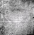
Ashoka Rock containing Greek and Aramaic inscriptions (3rd century BCE)
-
Kandahar Sophytos Inscription (2nd century BCE)
-
Shah Mahmud Hotak, son of Mirwais Hotak, took down the Safavid dynasty and became King of Persia in 1722
-
Ahmad Shah Durrani laid the foundation of the current city in 1747
British in Kandahar during the First Anglo-Afghan War
[edit]-
Army of British India at Kandahar in 1839
-
Life inside the city during the occupation of the British
-
View of the city in December 1841
British in Kandahar during the Second Anglo-Afghan War
[edit]-
Looking at Chilzina mountain in 1880
Buildings (ودانۍ)
[edit]-
Famous mosque of Kandahar
-
Governor's House
-
Downtown of Kandahar City
-
Shopping center in Shahr-e Noe neighborhood
-
Downtown area of the city
-
Azizi Bank in downtown


