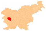
Žirovnica, Idrija
Appearance
Žirovnica | |
|---|---|
 | |
| Coordinates: 46°0′51.76″N 14°5′21.45″E / 46.0143778°N 14.0892917°E | |
| Country | |
| Traditional region | Inner Carniola |
| Statistical region | Gorizia |
| Municipality | Idrija |
| Area | |
| • Total | 1.56 km2 (0.60 sq mi) |
| Elevation | 543.2 m (1,782.2 ft) |
| Population (2002) | |
| • Total | 26 |
| [1] | |
Žirovnica (pronounced [ʒiˈɾoːu̯nitsa]; German: Scheraunitz[2]) is a small settlement in the valley of Žirovnica Creek, a tributary of the Poljane Sora River, south of Žiri in Slovenia. Although it is easily accessible by road only from the Žiri side, which is in the Upper Carniola region of Slovenia, it actually lies in the Municipality of Idrija[3] in the traditional Inner Carniola region.[2]
References
[edit]- ^ Statistical Office of the Republic of Slovenia
- ^ a b Leksikon občin kraljestev in dežel zastopanih v državnem zboru, vol. 6: Kranjsko. 1906. Vienna: C. Kr. Dvorna in Državna Tiskarna, pp. 124, 126.
- ^ Idrija municipal site
External links
[edit] Media related to Žirovnica at Wikimedia Commons
- Žirovnica on Geopedia

