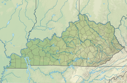
Martins Fork Lake
Appearance
| Martins Fork Lake | |
|---|---|
 Dam and Lake. View is to the west-northwest | |
| Location | Harlan County, Kentucky |
| Coordinates | 36°44′45″N 83°15′48″W / 36.7459°N 83.263321°W |
| Type | reservoir |
| Primary inflows | Martins Fork |
| Primary outflows | Martins Fork |
| Basin countries | United States |
| Max. length | [1] |
| Max. width | 2,570 ft (780 m) |
| Surface area | 340 acres (1.4 km2) |
| Max. depth | 45 ft (14 m)[2] |
| Surface elevation | 1,296 ft (395 m)[3] |

Martins Fork Lake is a 340-acre (1.4 km2) reservoir in Harlan County, Kentucky. The lake was impounded from the Martin's Fork in 1979 by the United States Army Corps of Engineers. It is named for James Martin, an early pioneer in the area.[4]
References
[edit]- ^ Because of this reservoir's irregular shape, determining a definite length would be an uncertain venture.
- ^ "Martins Fork Lake". www.lrn.usace.army.mil. Archived from the original on 18 March 2007. Retrieved 12 January 2022.
- ^ Fishingworks website, at https://www.fishingworks.com/kentucky/harlan-ky/lake/martins-fork-lake/ .
- ^ Kleber, John E., ed. (1992). "Lakes". The Kentucky Encyclopedia. Associate editors: Thomas D. Clark, Lowell H. Harrison, and James C. Klotter. Lexington, Kentucky: The University Press of Kentucky. ISBN 0-8131-1772-0.
External links
[edit]


