Maungakiekie-Tāmaki
Appearance
Maungakiekie-Tāmaki | |
|---|---|
Local board area | |
 | |
| Country | New Zealand |
| Region | Auckland |
| Territorial authority | Auckland |
| Ward | Maungakiekie-Tāmaki Ward |
| Local board | Maungakiekie-Tāmaki Local Board |
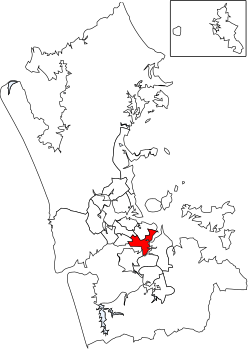
Maungakiekie-Tāmaki is a local government area in Auckland, in New Zealand's Auckland Region. It is governed by the Maungakiekie-Tāmaki Local Board and Auckland Council, and aligns with the council's Maungakiekie-Tāmaki Ward.[1]
Geography
[edit]The area is the south-eastern part of the Auckland isthmus. It includes the suburbs of Glen Innes, Point England, Tāmaki, Panmure, Mount Wellington, Westfield, Penrose, Oranga, Onehunga, Southdown and One Tree Hill.[1]
There are several geographic features, including:
Features
[edit]The local board includes the major retail areas of Panmure, Onehunga and Sylvia Park. Manufacturing, bulk storage and distribution are major employers.[1]
Mt Smart Stadium is also located within the area.[1]
References
[edit]- ^ a b c d e "Council profile". aucklandcouncil.govt.nz. Auckland Council.