Pale-Prača
Appearance
This article needs additional citations for verification. (March 2018) |
Pale-Prača
Пале-Прача | |
|---|---|
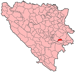
 Location of Pale-Prača within Bosnia and Herzegovina. | |
| Coordinates: 43°45′50″N 18°45′50″E / 43.76389°N 18.76389°E | |
| Country | |
| Entity | Federation of Bosnia and Herzegovina |
| Canton | |
| Geographical region | Podrinje |
| Government | |
| • Municipal mayor | Almin Ćutuk (SDA) |
| Area | |
| • Total | 864 km2 (334 sq mi) |
| Population (2013) | |
| • Total | 904 |
| • Density | 12/km2 (30/sq mi) |
| Time zone | UTC+1 (CET) |
| • Summer (DST) | UTC+2 (CEST) |
| Area code | +387 38 |
| Website | www |
Pale-Prača (Serbian Cyrillic: Пале-Прача) is a municipality located in Bosnian-Podrinje Canton Goražde of the Federation of Bosnia and Herzegovina, an entity of Bosnia and Herzegovina. The center of the municipality is Prača. According to the 2013 census, the municipality has 904 inhabitants.[1]
Demographics
[edit]Settlements
[edit]The municipality consists of 15 settlements with their respective populations:[2]
- Brdarići - 20
- Brojnići - 27
- Bulozi - 6
- Čeljadinići - 48
- Čemernica - 37
- Datelji - 112
- Donja Vinča - uninhabited
- Kamenica - uninhabited
- Komrani - 20
- Prača - 304
- Renovica - 39
- Srednje - uninhabited
- Šainovići - 111
- Turkovići - 169
- Vražalice - 11
2013 census
[edit]| Municipality | Nationality | Total
| |||||||
|---|---|---|---|---|---|---|---|---|---|
Bosniaks
|
%
|
Croats
|
%
|
Serbs
|
%
|
Undeclared and other | %
| ||
| Pale-Prača | 859 |
95.02
|
1 |
0.11
|
33 |
3.65
|
11
|
1.21
|
904
|
Features
[edit]The geographical location, fertile soil, great climate, and rich forests led many people to inhabit the municipality in early times. Today many remains from the medieval times can be found in the municipality of Pale-Prača.
See also
[edit]References
[edit]External links
[edit]Wikimedia Commons has media related to Pale-Prača Municipality.
