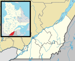
Roxton Pond
Roxton Pond | |
|---|---|
 Aerial view of Roxton Pond | |
Location within La Haute-Yamaska RCM | |
| Coordinates: 45°29′N 72°40′W / 45.483°N 72.667°W[1] | |
| Country | Canada |
| Province | Quebec |
| Region | Estrie |
| RCM | La Haute-Yamaska |
| Constituted | December 17, 1997 |
| Government | |
| • Mayor | Raymond Loignon |
| • Federal riding | Shefford |
| • Prov. riding | Johnson |
| Area | |
• Total | 103.40 km2 (39.92 sq mi) |
| • Land | 97.64 km2 (37.70 sq mi) |
| Population (2021)[4] | |
• Total | 4,224 |
| • Density | 43.3/km2 (112/sq mi) |
| • Pop 2016-2021 | |
| • Dwellings | 1,840 |
| Time zone | UTC−05:00 (EST) |
| • Summer (DST) | UTC−04:00 (EDT) |
| Postal code(s) | |
| Area code(s) | 450 and 579 |
| Highways | |
| Website | www |
Roxton Pond is a municipality in the Canadian province of Quebec, located within La Haute-Yamaska Regional County Municipality. The population as of the 2021 Canadian Census was 4,224. The municipality was created in 1997 with the merger of the Parish and the Village of Roxton Pond.
History
[edit]It was from 1790 that the British government of Canada divided the lands east of the Richelieu River valley into townships. The townships were largely granted to loyalists who, in exchange, had to commit to populating these territories to develop colonization.
Roxton Township, which included present-day Roxton Pond, Roxton and Roxton Falls, was given in 1803 to Elizabeth Ruite, widow of a military commander. In 1895, a first municipality was created under the name Sainte-Pudentienne. In 1886, the village and parish of Sainte-Pudentienne are split to form two distinct municipalities and will both change their name to Roxton Pond in 1985, nearly a hundred years later. Finally, the village and parish merges in 1997 to form the current municipality of Roxton Pond.
Demographics
[edit]Population
[edit]Population trend:[5]
| Census | Population | Change (%) |
|---|---|---|
| 2021 | 4,224 | |
| 2016 | 3,809 | |
| 2011 | 3,786 | |
| 2006 | 3,599 | |
| 2001 | 3,527 | N/A |
Language
[edit]Mother tongue language (2021)[6]
| Language | Population | Pct (%) |
|---|---|---|
| French only | 4,070 | 96.4% |
| English only | 70 | 1.7% |
| Both English and French | 40 | 0.9% |
| Other languages | 35 | 0.8% |
See also
[edit]References
[edit]- ^ "Banque de noms de lieux du Québec: Reference number 341093". toponymie.gouv.qc.ca (in French). Commission de toponymie du Québec.
- ^ a b Ministère des Affaires municipales, des Régions et de l'Occupation du territoire: Roxton Pond
- ^ Parliament of Canada Federal Riding History: SHEFFORD (Quebec)
- ^ a b 2021 Statistics Canada Census Profile: Roxton Pond, Quebec
- ^ Statistics Canada: 2001, 2006, 2011 census
- ^ 2021 Statistics Canada Community Profile: Roxton Pond, Quebec
External links
[edit] Media related to Roxton Pond at Wikimedia Commons
