Jump to content

San Andrés de Agues

Coordinates: 43°12′06″N 5°27′35″W / 43.20167°N 5.45972°W / 43.20167; -5.45972
From Wikipedia, the free encyclopedia
San Andrés de Agues
Soto de Agues
Parish
Image of the town, showing houses with red ceramic roof tiles, stone walls, a church, and the side of a mountain on the background.
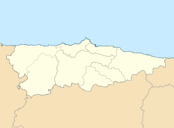
San Andrés de Agues is located in Asturias
San Andrés de Agues
San Andrés de Agues
Coordinates: 43°12′06″N 5°27′35″W / 43.20167°N 5.45972°W / 43.20167; -5.45972

San Andrés de Agues (variants: Agüés; Agüis; San Andrés d'Agues) is one of three parishes (administrative divisions) in Sobrescobio, a municipality within the province and autonomous community of Asturias, in northern Spain.

It is 35.63 km2 (13.76 sq mi) in size, with a population of 274 (INE 2005).

Villages

[edit]
  • Agüés
  • Soto
  • San Andrés


pFad - Phonifier reborn

Pfad - The Proxy pFad of © 2024 Garber Painting. All rights reserved.

Note: This service is not intended for secure transactions such as banking, social media, email, or purchasing. Use at your own risk. We assume no liability whatsoever for broken pages.


Alternative Proxies:

Alternative Proxy

pFad Proxy

pFad v3 Proxy

pFad v4 Proxy