Tocantins (negara bagian)
Tampilan
Artikel ini perlu dikembangkan agar dapat memenuhi kriteria sebagai entri Wikipedia. Bantulah untuk mengembangkan artikel ini. Jika tidak dikembangkan, artikel ini akan dihapus. |
State of Tocantins | |
|---|---|
| Motto: "Co yvy ore retama" (Translated from Tupi: "This land is ours") | |
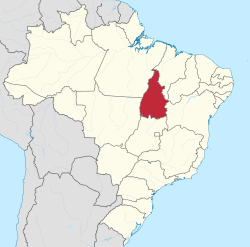
 Location of State of Tocantins in Brazil | |
| Koordinat: 10°11′S 48°20′W / 10.183°S 48.333°W | |
| Country | |
| Capital and Largest City | Palmas |
| Pemerintahan | |
| • Governor | Marcelo Miranda |
| • Vice Governor | Claúdia Lelis |
| Luas | |
| • Total | 277.620,91 km2 (10,719,003 sq mi) |
| Peringkat | 10th |
| Populasi (2014)[1] | |
| • Total | 1.496.880 |
| • Peringkat | 24th |
| • Kepadatan | 0/km2 (0/sq mi) |
| • Peringkat kepadatan | 22nd |
| Demonim | Tocantinense |
| GDP | |
| • Year | 2006 estimate |
| • Total | R$ 9,607,000,000 (24th) |
| • Per capita | R$ 7,210 (17th) |
| HDI | |
| • Year | 2014 |
| • Category | 0.732 – high (13th) |
| Zona waktu | UTC-3 (BRT) |
| Postal Code | 77000-000 to 77990-000 |
| Kode ISO 3166 | BR-TO |
| Situs web | to.gov.br |
Tocantins adalah sebuah negara bagian di Brasil. Luas wilayah Tocantins adalah 277.297 km2. Ibu kota Tocantins terletak di Palmas. Penduduk Tocantins sebanyak 1.155.913 jiwa.
- ^ Kesalahan pengutipan: Tag
<ref>tidak sah; tidak ditemukan teks untuk ref bernamai

