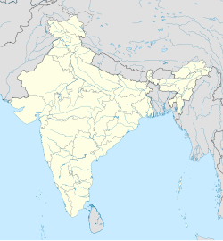
ഇന്ദിര പോയിന്റ്
ദൃശ്യരൂപം
Indira Point | |
|---|---|
Village | |
| Coordinates: 6°46′50″N 93°49′33″E / 6.780621°N 93.8258513°E | |
| Country | India |
| State | Andaman and Nicobar Islands |
| District | Nicobar |
| Tehsil | Great Nicobar |
| ഉയരം | 47 മീ(154 അടി) |
(2011) | |
| • ആകെ | 27 |
| സമയമേഖല | UTC+5:30 (IST) |
| 2011 census code | 645188 |
ഇന്ത്യൻ റിപ്പബ്ലിക്കിന്റെ ഏറ്റവും തെക്കേ അറ്റമാണ് ഇന്ദിര പോയിന്റ്. ആന്തമാൻ നിക്കോബാർ ദ്വീപുകളിലെ ഗ്രേറ്റ് നിക്കോബാർ ദ്വീപിന്റെ തെക്കേ അറ്റത്തായി ഇത് സ്ഥിതി ചെയ്യുന്നു. 1985-ലാണ് ദ്വീപിനു മുൻ ഇന്ത്യൻ പ്രധാനമന്ത്രിയായിരുന്ന ഇന്ദിരഗാന്ധിയുടെ പേരു നൽകിയത്. ഹെലിപ്പാഡോടു കൂടിയ ഒരു വിളക്കുമാടമാണ് ഇവിടുത്തെ പ്രധാന കാഴ്ച. മലേഷ്യ-മലാക്ക-ഇന്ത്യ റൂട്ടിൽ സഞ്ചരിക്കുന്ന കപ്പലുകൾക്കുള്ള വഴികാട്ടിയാണ് ഈ വിളക്കുമാടം.[1]
അവലംബം
[തിരുത്തുക]- ↑ "ഇന്ദിര പോയിന്റ്, ഗ്രേറ്റ് നിക്കോബാർ". മലയാളം, നേറ്റീവ് പ്ലാനറ്റ്. Archived from the original on 2015-03-09. Retrieved 9 മാർച്ച് 2015.
{{cite web}}: CS1 maint: bot: original URL status unknown (link)

