Herefordshire
| Unitaire autoriteit in Engeland | |||
|---|---|---|---|
|
| |||

| |||
| Situering | |||
| Land | Engeland | ||
| Regio | West Midlands | ||
| Coördinaten | 52°5'NB, 2°45'WL | ||
| Algemeen | |||
| Oppervlakte | 2179,7094[1] km² | ||
| Inwoners (2018[2]) |
192.107 (88 inw./km²) | ||
| ONS-code | E06000019 | ||
| Website | Officiële website | ||
| Detailkaart | |||

| |||
| |||
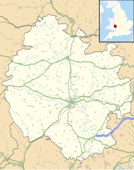
Herefordshire is een unitary authority en een district in de Engelse regio West Midlands en telde 191.041 inwoners in 2017. De oppervlakte bedraagt 2180 km².
Geografie
[bewerken | brontekst bewerken]Het gebied grenst aan de graafschappen Shropshire in het noorden, Worcestershire in het oosten, Gloucestershire in het zuiden en de Welsh graafschappen Gwent in het zuidwesten en Powys in het westen.
De belangrijkste rivier is de Wye, die door onder meer Ross-on-Wye en hoofdstad Hereford stroomt.
Herefordshire omvat twee Areas of Outstanding Natural Beauty, te weten de vallei van de rivier de Wye en de Malvern Hills.
Demografie
[bewerken | brontekst bewerken]Van de bevolking is 19,2 % ouder dan 65 jaar. De werkloosheid bedraagt 2,7 % van de beroepsbevolking (cijfers volkstelling 2001).
Het aantal inwoners steeg van ongeveer 160.400 in 1991 naar 183.477 in 2011.
Plaatsen in district Herefordshire
[bewerken | brontekst bewerken]Civil parishes in het district Herefordshire
[bewerken | brontekst bewerken]Abbey Dore, Aconbury, Acton Beauchamp, Adforton, Allensmore, Almeley, Ashperton, Aston Ingham, Avenbury, Aylton, Aymestrey, Bacton, Ballingham, Bartestree, Belmont Rural, Birley with Upper Hill, Bishop’s Frome, Bishopstone, Blakemere, Bodenham, Bolstone, Bosbury, Brampton Abbotts, Brampton Bryan, Bredenbury, Bredwardine, Breinton, Bridge Sollers, Bridstow, Brilley, Brimfield, Brinsop and Wormsley, Brobury with Monnington on Wye, Brockhampton (Bringsty Ward), Brockhampton (Old Gore Ward), Bromyard and Winslow, Buckton and Coxall, Burghill, Burrington, Byford, Byton, Callow, Canon Frome, Canon Pyon, Castle Frome, Clehonger, Clifford, Coddington, Collington, Colwall, Combe, Cradley, Craswall, Credenhill, Croft and Yarpole, Cusop, Dewsall, Dilwyn, Dinedor, Dinmore, Docklow and Hampton Wafer, Donnington, Dormington, Dorstone, Downton, Dulas, Eardisland, Eardisley, Eastnor, Eaton Bishop, Edvin Loach and Saltmarshe, Edwyn Ralph, Eggleton, Elton, Evesbatch, Ewyas Harold, Eye, Moreton and Ashton, Eyton, Felton, Ford and Stoke Prior, Fownhope, Foy, Ganarew, Garway, Goodrich, Grafton, Grendon Bishop, Hampton Bishop, Hampton Charles, Harewood, Hatfield and Newhampton, Haywood, Hentland, Hereford, Holme Lacy, Holmer & Shelwick, Hope Mansell, Hope under Dinmore, How Caple, Humber, Huntington, Kenchester, Kenderchurch, Kentchurch, Kilpeck, Kimbolton, King’s Pyon, Kings Caple, Kingsland, Kingstone, Kington, Kington Rural, Kinnersley, Kinsham, Knill, Laysters, Lea, Ledbury, Leinthall Starkes, Leintwardine, Leominster, Letton, Lingen, Linton (Bringsty Ward), Linton (Penyard Ward), Little Birch, Little Cowarne, Little Dewchurch, Little Hereford, Little Marcle, Llancillo, Llandinabo, Llangarron, Llanrothal, Llanveynoe, Llanwarne, Longtown, Lower Bullingham, Lower Harpton, Lucton, Lugwardine, Luston, Lyonshall, Madley, Mansell Gamage, Mansell Lacy, Marden, Marstow, Mathon, Michaelchurch Escley, Middleton on the Hill, Moccas, Monkland and Stretford, Mordiford, Moreton Jeffries, Moreton on Lugg, Much Birch, Much Cowarne, Much Dewchurch, Much Marcle, Munsley, Newton (Golden Valley South Ward), Newton (Hampton Court Ward), Norton, Norton Canon, Ocle Pychard, Orcop, Orleton, Pembridge, Pencombe with Grendon Warren, Pencoyd, Peterchurch, Peterstow, Pipe Aston, Pipe and Lyde, Pixley, Preston Wynne, Preston on Wye, Pudlestone, Putley, Richards Castle (Hereford), Rodd, Nash and Little Brampton, Ross Rural, Ross-on-Wye, Rowlstone, Sarnesfield, Sellack, Shobdon, Sollers Hope, St. Devereux, St. Margarets, St. Weonards, Stanford Bishop, Stapleton, Staunton on Arrow, Staunton on Wye, Stoke Edith, Stoke Lacy, Stretton Grandison, Stretton Sugwas, Sutton, Tarrington, Tedstone Delamere, Tedstone Wafer, Thornbury, Thruxton, Titley, Tretire with Michaelchurch, Treville, Turnastone, Tyberton, Ullingswick, Upper Sapey, Upton Bishop, Vowchurch, Wacton, Walford, Walford, Letton and Newton, Walterstone, Wellington, Wellington Heath, Welsh Bicknor, Welsh Newton, Weobley, Westhide, Weston Beggard, Weston under Penyard, Whitbourne, Whitchurch, Whitney-on-Wye, Wigmore, Willersley and Winforton, Willey, Withington, Wolferlow, Woolhope, Wormbridge, Yarkhill, Yatton, Yazor.
Spoorwegen
[bewerken | brontekst bewerken]Economie
[bewerken | brontekst bewerken]
Herefordshire bestaat grotendeels uit agrarisch gebied en staat bekend om de productie van fruit, cider (onder meer het merk Strongbow) en om het koeienras Hereford.
Rivier
[bewerken | brontekst bewerken]- ↑ Office for National Statistics → Download → SAM_for_Administrative_Areas_(2018).zip → SAM_LAD_DEC_2018_UK.xlsx. Gearchiveerd op 12 juni 2023.
- ↑ https://www.ons.gov.uk/file?uri=/peoplepopulationandcommunity/populationandmigration/populationestimates/datasets/populationestimatesforukenglandandwalesscotlandandnorthernireland/mid20182019laboundaries/ukmidyearestimates20182019ladcodes.xls Schatting Office for National Statistics: knop MYE5 → kolom Estimated Population mid-2018]

