Wildfire Cameras
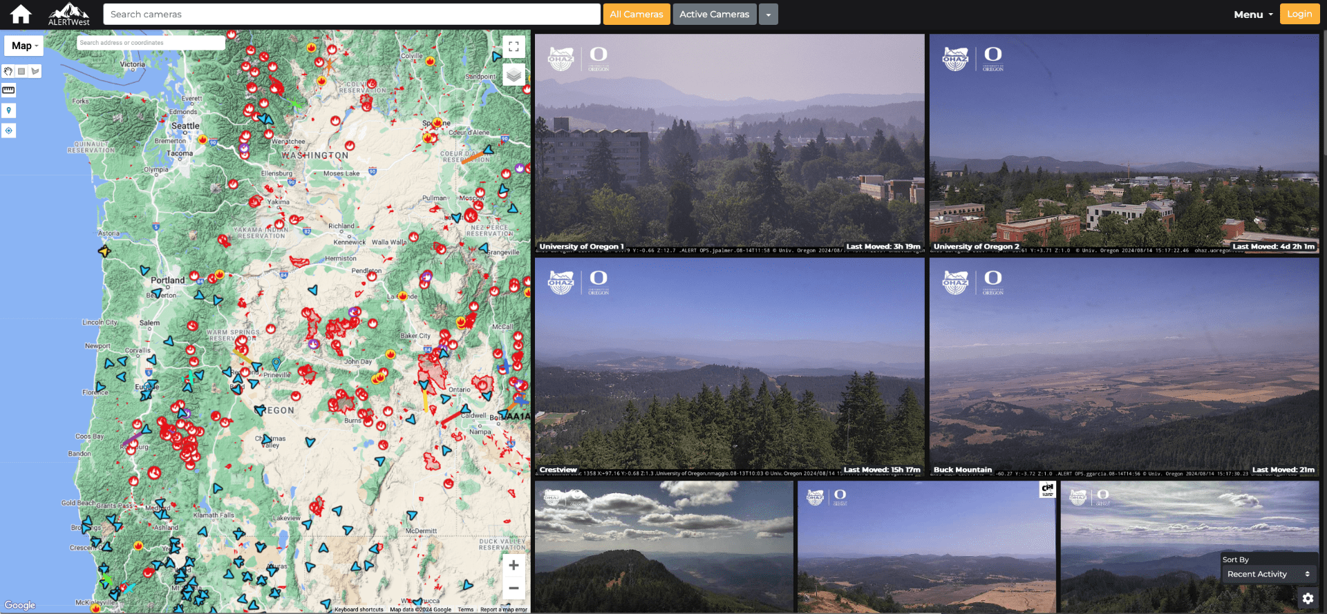
A 21st Century Firespotting SystemThe Oregon Hazards Lab operates a high-speed camera network that gives firefighters a new way to spot and track wildfires. Cameras are typically installed on top of tall mountains or high-rise buildings with 360-degree views of the surrounding landscape, enabling fire managers to watch the landscape, fire behavior, and weather in real-time or later through time-lapse footage. Our camera network is integrated with those operated by our collaborators: the University of Nevada, Reno and the University of California, San Diego. With dozens of cameras in Oregon and thousands in the Western United States, this is the largest wildfire camera network in the world.
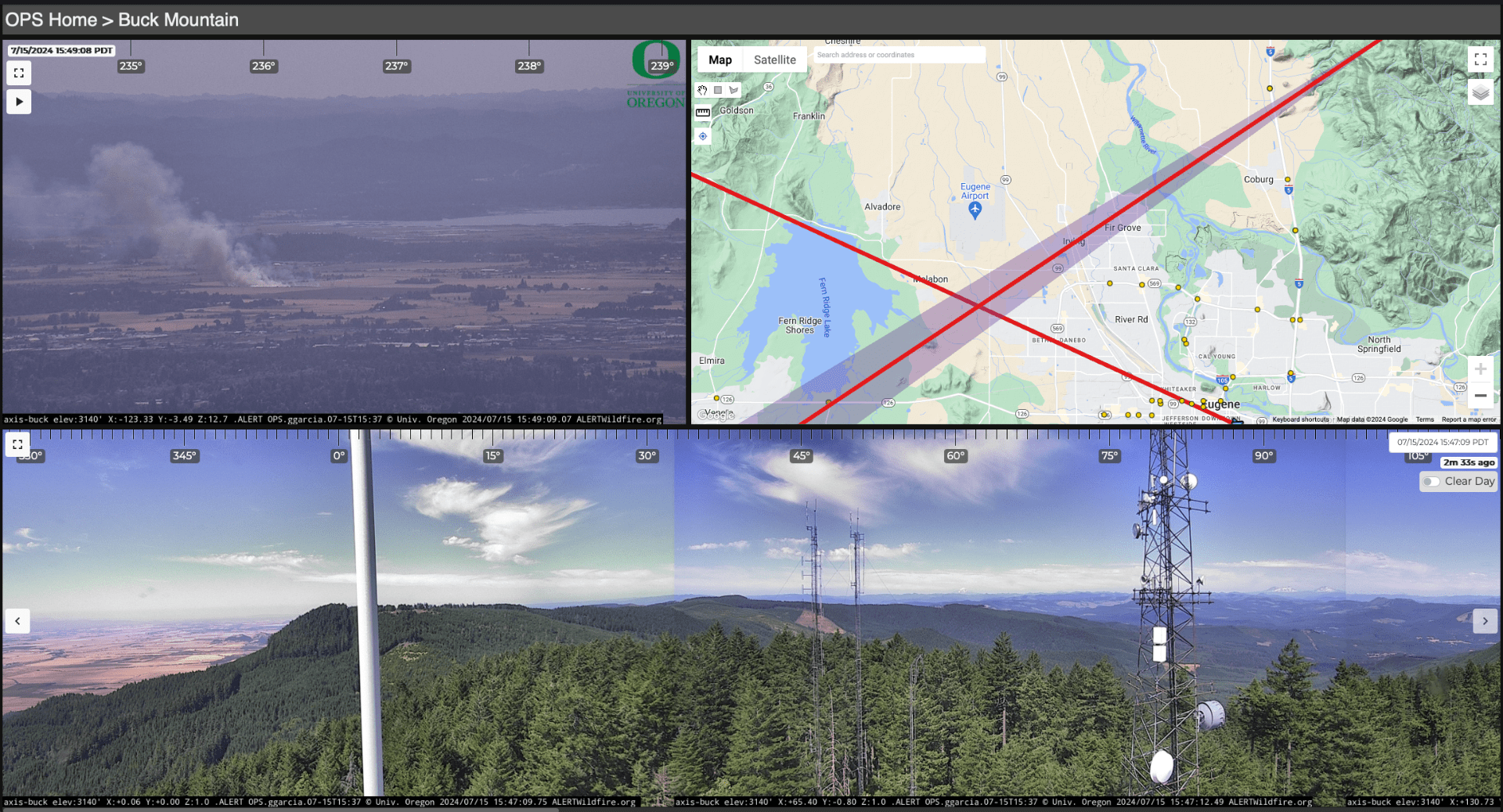
There are currently 54 wildfire cameras in Oregon, and we plan to operate 75 cameras across the state by late 2025. Each camera can rotate 360 degrees, tilt 220 degrees, and zoom up to 40 times. With near-infrared capabilities, they have a range of up to 30 miles in the daytime and 40 miles at night. These provide multiple benefits to firefighters and the general public, including:
-
- Discovering, locating, and confirming new fire starts
- Providing vital visual information to inform and scale response
- Enabling monitoring of fire behavior through containment
Automated wildfire detection is another tool firefighters can use to detect and suppress new fire starts before they become resource-intensive conflagrations.
Using the ALERTWest Camera Platform
Any member of the public can visit ALERTWest.live to watch live camera live feeds from over 1,200 cameras in Oregon, Washington, California, Idaho, Colorado, Hawaii, Montana, and Nevada. In addition to viewing live imagery, users can review timelapse videos and archived panoramic images that are taken every two minutes. The ALERTWest website also provides a map with additional situational awareness tools, including GIS layers for current wildfire perimeters, new fire starts, and thermal activity.

In addition to the tools available to the public, credentialed users have access to additional features on the ALERTWest platform. They can manually rotate, tilt, and zoom cameras, as well as view timelapse videos that are older than 24 hours. Credentialed users can also receive automated alerts when a new fire start is detected in their self-selected region. Every two minutes, ALERTWest software takes a panoramic image from each camera and scans the images for new ignitions using wildfire detection algorithms. Operations technicians at ALERTWest, our software provider, immediately review new detections to remove false detections, and then generate alerts for confirmed positive detections. Alerts are only delivered to credentialed users, not to the general public. Fire managers in Oregon began receiving automated alerts during the 2024 fire season.

Log-in credentials are available to firefighters, dispatchers, emergency managers, and others who demonstrate a public safety need. To receive credentials, email the Oregon Hazards Lab at wildfirehelp@uoregon.edu. You can also learn more about using the ALERTWest platform through these video tutorials:
Oregon Wildfire Detection Camera Interoperability Committee
Wildfire detection cameras have been in use in Oregon for over sixteen years. In addition to the camera network operated by the Oregon Hazards Lab, the Oregon Department of Forestry and multiple utilities operate other networks, although ours is the only network with publicly accessible footage. In 2022, the Governor’s office and federal agencies requested that agencies form the Oregon Wildfire Detection Camera Interoperability Committee (OWDCIC) to establish cooperation across the state in detection camera efforts.
The OWDCIC is chaired by Leland O’Driscoll, Associate Director of the Oregon Hazards Lab, and Jamie Paul of the Oregon Department of Forestry. Other members include the Statewide Interoperability Coordinator, representatives from the Governor’s Office, public safety agencies, structural fire agencies, utilities, emergency managers, the U.S. Forest Service, the Bureau of Land Management, and tribal governments.
The OWDCIC’s mission is to build relationships and communication between agencies, increase technological interoperability and resilience, and to identify and implement best practices to achieve interoperable fire tools that support response agencies at a statewide scale. Committee work has resulted in accomplishments such as development of a statewide combined detection map GIS layer, annual efficacy reporting, and elimination of conflicts in siting and permitting between agencies. Technologies explored include remote deployable temporary camera towers and the use of alternate data backhaul providers such as Starlink.
Wildfire Cameras in the Rogue Valley
The Oregon Hazards Lab has partnered with the Rogue Valley Council of Governments to apply for a grant from the Federal Emergency Management Agency. This funding would enable us to install twelve additional wildfire cameras in the Rogue Valley in starting in the summer of 2024. These cameras will complement existing wildfire cameras in the region. Together, they will provide a comprehensive viewshed of this high-risk corridor, including Medford, Grants Pass, Cave Junction, and Eagle Point.

Learning More About Wildfire Cameras
What organizations and agencies use wildfire cameras?
Over 200 individuals from more than 50 different agencies have log-in credentials to control cameras in Oregon. These users include the American Red Cross, the Bureau of Land Management, the Oregon Department of Forestry, the U.S. Forest Service, the U.S. Army Corps of Engineers, NOAA, Oregon Department of Transportation, Oregon State Police, Oregon State Fire Marshall, local fire departments, local governments, and utilities.
Who are our collaborators in operating the wildfire camera network?
The University of Oregon cooperatively operates its camera network our collaborators, the University of Nevada, Reno; and the University of California, San Diego. We have contracted the private technology platform ALERTWest to host our cameras. We also collaborate with diverse federal, state, and county agencies; utilities; and local stakeholders in leveraging funding and installing cameras. Our Oregon sponsors and partners include the State of Oregon, the Bureau of Land Management, the Oregon Department of Transportation, Eugene Water and Electric Board, Rogue Valley Council of Governments, Lane Council of Governments, Lane County Educational Service District, Lane County Sheriff’s Office, Klamath Falls Community College, KATU2, Elevate Technology Group, Rogue Broadband, and Illinois Valley Data Center.
How do wildfire cameras support a multi-hazards observing network?
The Oregon Hazards Lab is increasingly co-locating wildfire detection cameras and Pacific Northwest Seismic Network seismic monitoring stations. The high-speed telemetry backbone needed to transmit images and videos in real-time can be leveraged to deliver real-time, state-wide monitoring for a multi-hazard system. Because wildfire cameras already require high bandwidth, this network is easily expandable to other low-bandwidth sensors like seismometers for the ShakeAlert Earthquake Early Warning System. Co-locating sites provides mutual benefits. Communities face a multitude of hazards, which cannot be addressed by a single-hazard detection system. Because monitoring networks are expensive and difficult to maintain, co-locating sites is both cost-effective and improves statewide resiliency for a variety of natural hazards. Seismic stations can take advantage of the cameras’ solar panels and high-bandwidth telemetry, whereas fire cameras benefit from seismic sites’ high standards for constant up-time, automatic failover, and redundancy. As of August 2024, there are 16 sites which host both a wildfire camera and seismic site.
Can people reshare images or videos from the wildfire cameras?
Live and timelapse footage from the Oregon Hazards Lab’s wildfire detection cameras are available for public use with credit.
- When using any images or videos, please credit “The Oregon Hazards Lab at the University of Oregon” verbally and in writing. “The Oregon Hazards Lab” can also be used.
- Tag @OHAZ_UO on Instagram and X if sharing a photo, video, or screen grab on social media.
- Do not crop or remove the black information bar at the bottom of screen grabs and videos.
- Do not crop or remove the Oregon Hazards Lab logo or partner logos.
- When using our logo, do not remove, rearrange, overlap, stretch, or change the proportions of any of its components. Additionally, do not alter the weight, color, or typeface or attach any other graphic elements.
Thank you for your understanding. If you have any questions or would like a copy of our logo for media use, please contact us by email at ohaz@uoregon.edu.
To learn more about our wildfire camera network or to receive camera control credentials, please email us at wildfirehelp@uoregon.edu.
