Altadena, California
Appearance
Altadena, California | |
|---|---|
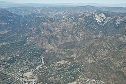
 Aerial view of Altadena and Eaton Canyon | |
 Location of Altadena in Los Angeles County, California | |
| Coordinates: 34°11′19″N 118°8′5″W / 34.18861°N 118.13472°W | |
| Country | |
| State | |
| County | |
| Area | |
| • Total | 8.48 sq mi (21.97 km2) |
| • Land | 8.46 sq mi (21.92 km2) |
| • Water | 0.02 sq mi (0.04 km2) 0.19% |
| Elevation | 1,358 ft (414 m) |
| Population | |
| • Total | 42,846 |
| • Density | 5,061.55/sq mi (1,954.26/km2) |
| Time zone | UTC−8 (Pacific) |
| • Summer (DST) | UTC−7 (PDT) |
| ZIP Codes | 91001, 91003 |
| Area code | 626 |
| FIPS code | 06-01290 |
| GNIS feature IDs | 1652662, 2407732 |
Altadena is an unincorporated census-designated place of Los Angeles County in the state of California, in the United States. 42,846 people were living in Altadena as of 2020.[3] It is about fourteen miles from downtown Los Angeles. It was built as a suburb of Pasadena in 1887. However, although it was meant to be a suburb of Pasadena, it has so far refused to become part of Pasadena.
References
[change | change source]- ↑ "2020 U.S. Gazetteer Files". United States Census Bureau. Retrieved October 30, 2021.
- ↑ "Altadena". Geographic Names Information System. United States Geological Survey. Retrieved October 19, 2014.
- ↑ 3.0 3.1 "QuickFacts: Altadena CDP, Colorado". United States Census Bureau. Retrieved August 8, 2023.
Other websites
[change | change source] Media related to Altadena, California at Wikimedia Commons
- Altadena Town Council
- Altadena Chamber of Commerce


