Astara District
Appearance
Astara | |
|---|---|
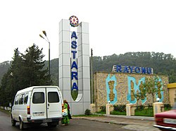
 Road sign at the entrance to Astara Raion | |
 Map of Azerbaijan showing Astara Raion | |
| Coordinates: =inline,title | |
| Country | Azerbaijan |
| Capital | Astara |
| Area | |
| • Total | 620 km2 (240 sq mi) |
| Population (2008)[1] | |
| • Total | 95,300 |
| • Density | 150/km2 (400/sq mi) |
Astara is a raion in southeastern Azerbaijan. It was formed in 1930. There are 95,300 people.[1] Astarachay and Tangarud rivers are in the raion. A part of the Hirkan National Park is in Astara raion. Astara is a major source for Azerbaijan's fishing industry.
