Ciudad Juárez
Appearance
Heroica Ciudad Juárez | |
|---|---|
 Collage of Juárez scenes | |
| Nickname(s): Paso del Norte, "Juárez" | |
| Motto(s): Refugio de la libertad, custodia de la republica (Spanish for "Refuge of liberty, guard of the republic") | |
| Coordinates: 31°44′22″N 106°29′13″W / 31.73944°N 106.48694°W | |
| Country | |
| State | Chihuahua |
| Municipality | Juárez |
| Foundation | 1659 |
| Government | |
| • Municipal president | Armando Cabada (Ind.) |
| Area | |
| • City | 321.19 km2 (124.01 sq mi) |
| Elevation | 1,137 m (3,730 ft) |
| Population (2010)[2] | |
| • City | 1,521,004 |
| • Density | 7,027/km2 (19,290/sq mi) |
| • Metro | 2,539,946 [1] |
| • Demonym | Juarense |
| Time zone | UTC−7 (MST) |
| • Summer (DST) | UTC−6 (MDT) |
| Area code | +52 656 |
| Climate | BWk |
| Website | http://www.juarez.gob.mx |
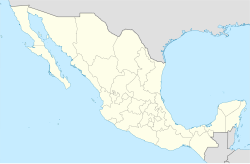
Ciudad Juárez is a city in the Mexician state of Chihuahua. About 1,600,000 people live in Ciudad Juárez. This makes it the fifth largest city in Mexico and the largest city in Chihuahua. It is at the border to the USA, opposite El Paso.
References
[change | change source]- ↑ "elpasoredco.org". Archived from the original on September 18, 2013. Retrieved August 26, 2016.
- ↑ "Juárez". Catálogo de Localidades. Secretaría de Desarrollo Social (SEDESOL). Archived from the original on April 12, 2015. Retrieved April 23, 2014.
Wikimedia Commons has media related to Ciudad Juárez.

