Columbia County, Wisconsin
Appearance
Columbia County | |
|---|---|
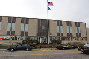
 Columbia County courthouse in December 2014 | |
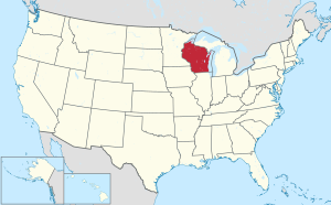
 Location within the U.S. state of Wisconsin | |
 Wisconsin's location within the U.S. | |
| Coordinates: 43°28′N 89°20′W / 43.47°N 89.33°W | |
| Country | |
| State | |
| Founded | 1846 |
| Named for | Christopher Columbus |
| Seat | Portage |
| Largest city | Portage |
| Area | |
| • Total | 796 sq mi (2,060 km2) |
| • Land | 766 sq mi (1,980 km2) |
| • Water | 30 sq mi (80 km2) 3.8% |
| Population | |
| • Total | 58,490 |
| • Density | 76.4/sq mi (29.5/km2) |
| Time zone | UTC−6 (Central) |
| • Summer (DST) | UTC−5 (CDT) |
| Congressional district | 6th |
| Website | www |
Columbia County is a county in the U.S. state of Wisconsin. As of 2020, 58,490 people lived in Columbia county.[1] Portage is the county seat and largest city in the county.[2]
Columbia County is part of the Madison Metropolitan Statistical Area.
| Historical population | |||
|---|---|---|---|
| Census | Pop. | %± | |
| 1850 | 9,565 | — | |
| 1860 | 24,441 | 155.5% | |
| 1870 | 28,802 | 17.8% | |
| 1880 | 28,065 | −2.6% | |
| 1890 | 28,350 | 1.0% | |
| 1900 | 31,121 | 9.8% | |
| 1910 | 31,129 | 0.0% | |
| 1920 | 30,468 | −2.1% | |
| 1930 | 30,503 | 0.1% | |
| 1940 | 32,517 | 6.6% | |
| 1950 | 34,023 | 4.6% | |
| 1960 | 36,708 | 7.9% | |
| 1970 | 40,150 | 9.4% | |
| 1980 | 43,222 | 7.7% | |
| 1990 | 45,088 | 4.3% | |
| 2000 | 52,468 | 16.4% | |
| 2010 | 56,833 | 8.3% | |
| 2020 | 58,490 | 2.9% | |
| U.S. Decennial Census[3] 1790–1960[4] 1900–1990[5] 1990–2000[6] 2010–2020[1] | |||
Geography
[change | change source]The county has a total area of 796 square miles (2,061.6 km2). Of this, 774 square miles (2,004.7 km2) is land and 22 square miles (57.0 km2) (2.75%) is water. The county's highest point is Gibraltar Rock. It is 1,247 feet (380.1 m) above sea level. The high butte-shaped bluff is located north of Lodi. It looks out over the Lake Wisconsin River valley.
Cities, villages, and towns
[change | change source]- Arlington (town)
- Arlington (village)
- Caledonia (town)
- Cambria (village)
- Columbus (city)
- Columbus (town)
- Courtland (town)
- Dekorra (town)
- Doylestown (village)
- Fall River (village)
- Fort Winnebago (town)
- Fountain Prairie (town)
- Friesland (village)
- Hampden (town)
- Leeds (town)
- Lewiston (town)
- Lodi (town)
- Lodi (city)
- Lowville (town)
- Marcellon (town)
- Newport (town)
- Otsego (town)
- Pacific (town)
- Pardeeville (village)
- Portage (city)
- Poynette (village)
- Randolph (town)
- Randolph (village) (partial)
- Rio (village)
- Scott (town)
- Springvale (town)
- West Point (town)
- Wisconsin Dells (city) (partial)
- Wyocena (town)
- Wyocena (village)
Unincorporated communities
[change | change source]- Anacker
- Belle Fountain
- Dekorra
- Durwards Glen
- East Friesland
- Englewood
- Harmony Grove
- Ingle
- Keyeser
- Lake Wisconsin (partial)
- Leeds
- Leeds Center
- Lewiston
- Lowville
- Marcellon
- North Leeds
- Okee
- Otsego
Ghost towns
[change | change source]References
[change | change source]- ↑ 1.0 1.1 1.2 "QuickFacts: Columbia County, Wisconsin". United States Census Bureau. Retrieved January 20, 2024.
- ↑ "Find a County". National Association of Counties. Retrieved 2008-01-31.
- ↑ "U.S. Decennial Census". United States Census Bureau. Retrieved August 2, 2015.
- ↑ "Historical Census Browser". University of Virginia Library. Archived from the original on August 11, 2012. Retrieved August 2, 2015.
- ↑ Forstall, Richard L., ed. (March 27, 1995). "Population of Counties by Decennial Census: 1900 to 1990". United States Census Bureau. Retrieved August 2, 2015.
- ↑ "Census 2000 PHC-T-4. Ranking Tables for Counties: 1990 and 2000" (PDF). United States Census Bureau. April 2, 2001. Archived (PDF) from the original on 2022-10-09. Retrieved August 2, 2015.
