Cumberland Plateau

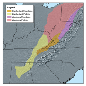
The Cumberland Plateau is the southern Appalachian or Cumberland Plateau in the Appalachian Mountains of the United States.
The Plateau includes parts of Kentucky and Tennessee, northern Alabama and northwest Georgia.[1]
The terms "Allegheny Plateau" and the "Cumberland Plateau" both refer to the heavily ridged plateau lands west of the main Appalachian Mountains. The terms come from historical usage. Two major rivers share the names of the plateaus, with the Allegheny River rising in the Allegheny Plateau and the Cumberland River rising in the Cumberland Plateau in Harlan County, Kentucky.
This was early coal-mining territory, and the area had some famous and tragic coal mining accidents.
As mentioned in the article Allegheny Mountains, the mountains are the low ground-down rock of a once huge mountain chain. The land ridges are difficult to cross SE to NW (or vice versa), and this lead to mountain folk being semi-isolated from the lower areas to either side of the mountains.