Haute-Savoie
Upper Savoy
Haute-Savoie | |
|---|---|
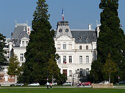
 Prefecture building of the Haute-Savoie department, in Annecy | |
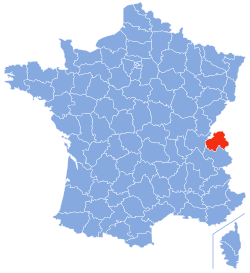
 Location of Haute-Savoie in France | |
| Coordinates: 46°00′N 06°20′E / 46.000°N 6.333°E | |
| Country | France |
| Region | Auvergne-Rhône-Alpes |
| Département | 1860 |
| Prefecture | Annecy |
| Subprefectures | Bonneville, Saint-Julien-en-Genevois, Thonon-les-Bains |
| Government | |
| • President | Christian Montei[1] |
| Area | |
| • Total | 4,387.8 km2 (1,694.1 sq mi) |
| Population (2014)[3] | |
| • Total | 783,127 |
| • Density | 180/km2 (460/sq mi) |
| Demonym | Haut-Savoyards |
| Time zone | UTC+1 (CET) |
| • Summer (DST) | UTC+2 (CEST) |
| ISO 3166 code | FR-74 |
| Arrondissements | 4 |
| Cantons | 17 |
| Communes | 281 |
| Website | www.hautesavoie.fr |
Haute-Savoie is a département in the Auvergne-Rhône-Alpes region of southeastern France, bordering Switzerland and Italy.
Name
[change | change source]Before 1860, the territory of the modern Haute-Savoie and Savoie departments had been part of the Kingdom of Sardinia, as a Duchy, since 1713. Annexation of the region by France was made in 1860. In that year, the Emperor Napoléon III divided the territory in two departments: Savoie, to the south, with the city of Chambéry, and Haute-Savoie, to the north, with the city of Annecy.
Haute ("High") in the name Haute-Savoie is not because of the altitude but because of its position, to the north, in the territory.
History
[change | change source]The department of Haute-Savoie was created in 1860 from the northern part of the Duchy of Sardinia with four arrondissements: Annecy, Bonneville, Saint-Julien and Thonon. The capital was Annecy.[4]
On 10 September 1926, the arrondissement of Saint-Julien was eliminated but became again an arrondissement in 1933.[4]
During World War II, the department was occupied by the fascist Italy, from November 1942 to September 1943.
Geography
[change | change source]The Haute-Savoie is part of the Auvergne-Rhône-Alpes region. It has an area of 4,387.8 km2 (1,694 sq mi).[2]
The department borders with the Ain and Savoie departments, both in the Auvergne-Rhône-Alpes region, and with Switzerland and Italy.
In the territory of the department is a part of the Mont Blder with Italy. The average altitude of the department is of about 1,160 m (3,810 ft). The highest point in the department is Mont Blanc (45°49′58″N 6°51′53″E / 45.83278°N 6.86472°E; it is 4,810 m (15,781 ft) high, the highest point of France, Italy and of Western Europe.[5]
The Haute-Savoie department is within the watershed of the Rhône river but with short rivers. There are two important lakes in the department: the Lake Geneva, shared with Switzerland, and the Lake Annecy.
Climate
[change | change source]The Köppen climate classification type for the climate at Annecy is an "Oceanic climate" (also known as Maritime Temperate climate) and of the subtype Cfb.
Administration
[change | change source]Haute-Savoie is managed by the Departmental
of Haute-Savoie in Annecy. The department is part of the Auvergne-Rhône-Alpes region.
Administrative divisions
[change | change source]There are 4 arrondissements (districts), 17 cantons and 281 communes (municipalities) in Haute-Savoie.[6]
| INSEE code |
Arrondissement | Capital | Population[7] (2014) |
Area[8] (km²) |
Density (Inh./km²) |
Communes |
|---|---|---|---|---|---|---|
| 741 | Annecy | Annecy | 276,382 | 1,261.6 | 219.1 | 80 |
| 742 | Bonneville | Bonneville | 184,093 | 1,558.2 | 118.1 | 61 |
| 743 | Saint-Julien-en-Genevois | Saint-Julien-en-Genevois | 180,562 | 660.3 | 273.5 | 72 |
| 744 | Thonon-les-Bains | Thonon-les-Bains | 142,090 | 907.7 | 156.5 | 68 |
The following is a list of the 17 cantons of the Haute-Savoie department (with their INSEE codes), following the French canton reorganisation which came into effect in March 2015:[9]
- Annecy-1 (7401)
- Annecy-2 (7402)
- Annecy-le-Vieux (7403)
- Annemasse (7404)
- Bonneville (7405)
- Cluses (7406)
- Évian-les-Bains (7407)
- Faverges (7408)
- Gaillard (7409)
- Le Mont-Blanc (7410)
- La Roche-sur-Foron (7411)
- Rumilly (7412)
- Saint-Julien-en-Genevois (7413)
- Sallanches (7414)
- Sciez (7415)
- Seynod (7416)
- Thonon-les-Bains (7417)
Demographics
[change | change source]The inhabitants of Haute-Savoie are known, in French, as Haut-Savoyards (women: Haut-Savoyardes).[10]
Haute-Savoie had a population, in 2014, of 783,127,[3] for a population density of 178.5 inhabitants/km2. The arrondissement of Annecy, with 276,382 inhabitants, is the arrondissement with more inhabitants.[7]
Evolution of the population in Haute-Savoie

The communes in the department with more inhabitants are:
| City | Population (2014)[7] |
Arrondissement |
|---|---|---|
| Annecy | 53,285 | Annecy |
| Thonon-les-Bains | 34,973 | Thonon-les-Bains |
| Annemasse | 34,953 | Saint-Julien-en-Genevois |
| Seynod | 20,955 | Annecy |
| Annecy-le-Vieux | 20,469 | Annecy |
| Cluses | 17,510 | Bonneville |
| Cran-Gevrier | 17,257 | Annecy |
| Sallanches | 15,754 | Bonneville |
| Rumilly | 14,836 | Annecy |
| Saint-Julien-en-Genevois | 13,253 | Saint-Julien-en-Genevois |
Gallery
[change | change source]-
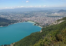
Annecy and Lake Annecy.
-
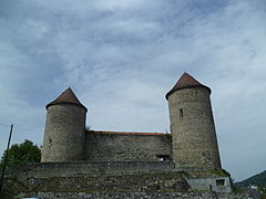
Bonneville castle.
-
The city hall of Saint-Julien-en-Genevois.
-
Thonon-les-Bains - fishermen town.
-
Thonon-les-Bains and the Mont-Blanc.
Related pages
[change | change source]References
[change | change source]- ↑ "Commission Permanente". Département de la Haute-Savoie. Retrieved 30 September 2017.
- ↑ 2.0 2.1 "Département de la Haute-Savoie (74)". Comparateur de territoire (in French). Institut national de la statistique et des études économiques - INSEE. Retrieved 30 September 2017.
- ↑ 3.0 3.1 "Populations légales 2014 des départements et des collectivités d'outre-mer" (in French). Institut national de la statistique et des études économiques - INSEE. Retrieved 30 September 2017.
- ↑ 4.0 4.1 "Historique de la Haute-Savoie". Le SPLAF (in French). Retrieved 30 September 2017.
- ↑ "Mont Blanc, France/Italy". Peakbagger.com. Retrieved 19 October 2016.
- ↑ "Département de la Haute-Savoie (74)" (in French). Institut national de la statistique et des études économiques - INSEE. Retrieved 30 September 2017.
- ↑ 7.0 7.1 7.2 "Régions, départements, arrondissements, cantons et communes" (PDF). Populations légales 2014 (in French). Institut national de la statistique et des études économiques - INSEE. Retrieved 30 September 2017.
- ↑ "Département de la Haute-Savoie (74)) et Arrondissements". Comparateur de territoire (in French). Institut national de la statistique et des études économiques - INSEE. Retrieved 30 September 2017.
- ↑ "Décret n° 2014-153 du 13 février 2014 portant délimitation des cantons dans le département de la Haute-Savoie" (in French). Légifrance.gouv.fr. Retrieved 30 September 2017.
- ↑ "Habitants du départment: Haute-Savoie" (in French). habitants.fr. Retrieved 30 September 2017.
Other websites
[change | change source]- Departmental Council website (in French)
- Prefecture website (in French)


