|
Contents Of This Report: |
|
National Drought Overview
|
|
[top]
Detailed Drought Discussion
Overview
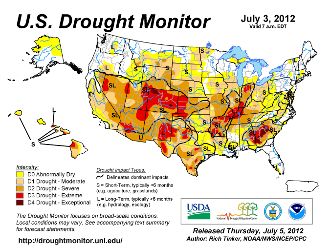
June 2012 was another warmer- and drier-than-average month (14th warmest and tenth driest June on record, based on data back to 1895) when weather conditions are averaged across the country. A strong high pressure system (High, or upper-level ridge) held sway over much of the U.S. for most of the month. Warm anomalies dominated the central regions at the monthly level and most of the country during the last half of the month (weeks 1, 2, 3, 4). Descending air ("subsidence") associated with the High inhibited precipitation in most areas, as seen in the precipitation pattern on the monthly scale as well as a weekly basis (weeks 1, 2, 3, 4). Above-normal precipitation fell in the northwest and northeast corners of the country — from active cold fronts and upper-level troughs — and across Florida and southeast Georgia from Tropical Storm Debby. Dry weather, in combination with increased evaporation caused by the record heat, expanded drought conditions in the West, Great Plains, and Midwest, while drought conditions remained fairly constant in Hawaii. Nationally, the moderate-to-exceptional (D1-D4) drought footprint increased to about 47 percent of the country while the percentage in the abnormally dry to exceptional drought category increased to about 71 percent. Both of these numbers are records in the 12-year USDM history. The previous records were 46 percent on September 10, 2002 and 66 percent on August 6, 2002, respectively. The Palmer Drought Index, whose data base goes back 112 years, is relied upon for drought comparisons before 2000. The June 2012 Palmer value of 55 percent is the largest percentage since December 1956 when 58 percent of the contiguous U.S. was in moderate to extreme drought.
By the end of the month, the core drought areas in the U.S. included:
- a large area of moderate (D1) to exceptional (D4) drought in the Southeast;
- moderate to extreme (D3) drought in the Southern Plains spreading into the Southwest;
- moderate to extreme drought in the Southwest to Intermountain Basin, with moderate to severe (D2) drought stretching to the West Coast, and into the Pacific Northwest and pockets of exceptional drought in Colorado;
- pockets of moderate to severe drought lingering in the Mid-Atlantic states, with abnormally dry areas in the Northeast states;
- moderate to extreme drought across much of the Midwest and Central to Northern Plains, with pockets of exceptional drought in the High Plains of Colorado; and
- parts of Hawaii, where moderate to extreme drought persisted.
Palmer Drought Index
The Palmer drought indices measure the balance between moisture demand (evapotranspiration driven by temperature) and moisture supply (precipitation). The Palmer Z Index depicts moisture conditions for the current month, while the Palmer Hydrological Drought Index (PHDI) and Palmer Drought Severity Index (PDSI) depict the current month's cumulative moisture conditions integrated over the last several months.
 |
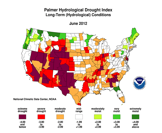 |
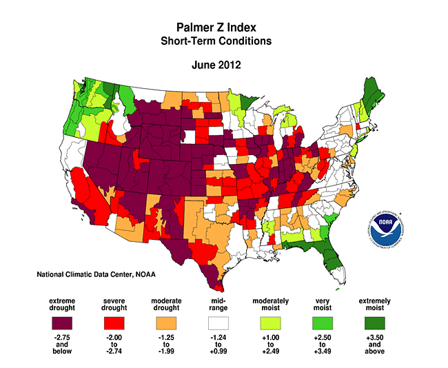
In many respects, June was a repeat of May. As seen on the June 2012 Palmer Z Index map, low precipitation and record hot temperatures (with the accompanying increased evapotranspiration) led to short-term drought across much of the country this month. Wet conditions are evident on the Z Index map in only a few areas — the Pacific Northwest, Florida, and northern New England. Much of the Eastern Seaboard has near normal Z Index values only because the first week or two were cooler than normal beneath an upper-level trough, resulting in below-normal monthly mean temperatures. The last half of the month had very warm temperatures in the East. Compared with the May 2012 PHDI map, the June 2012 PHDI map indicates that drought conditions improved in the Southeast, but intensified in the Midwest to Great Plains and much of the West. The June 2012 PHDI map also reflects the long-term nature of the drought conditions. The Z Index and PHDI maps in combination show that precipitation brought relief to parts of the Southeast drought areas, but for much of the rest of the country — drier-than-normal weather persisted over the existing drought areas and wetter-than-normal weather continued over the moist Pacific Northwest.
Did You Know?
Potential Evapotranspiration
The Palmer drought indices measure the balance between moisture demand and moisture supply. Drought results from an imbalance between these two components. Precipitation provides the water supply. Water demand is usually measured by evapotranspiration (the amount of water that would be evaporated and transpired by plants). There is a distinction made between potential evapotranspiration (PE) and actual evapotranspiration (AE). The Palmer model uses Thornthwaite's equations to estimate PE from temperature. PE is the demand or maximum amount of water that would be evapotranspired if enough water were available (from precipitation and soil moisture). AE is how much water actually is evapotranspired and is limited by the amount of water that is available. AE is always less than or equal to PE, so PE is used for the water demand component of the drought equation.
In the Palmer model, if the amount of precipitation (P) during the month is greater than PE for the month, then the leftover P soaks into the ground to recharge soil moisture, and any left over after that runs off as streamflow. If P is less than PE, then moisture has to be drawn out of the soil to meet the PE demand. Hotter temperatures result in greater PE which requires more P just to meet the greater demand. Climates where PE is always greater than P are termed arid climates. The American Southwest is a typical arid climate.
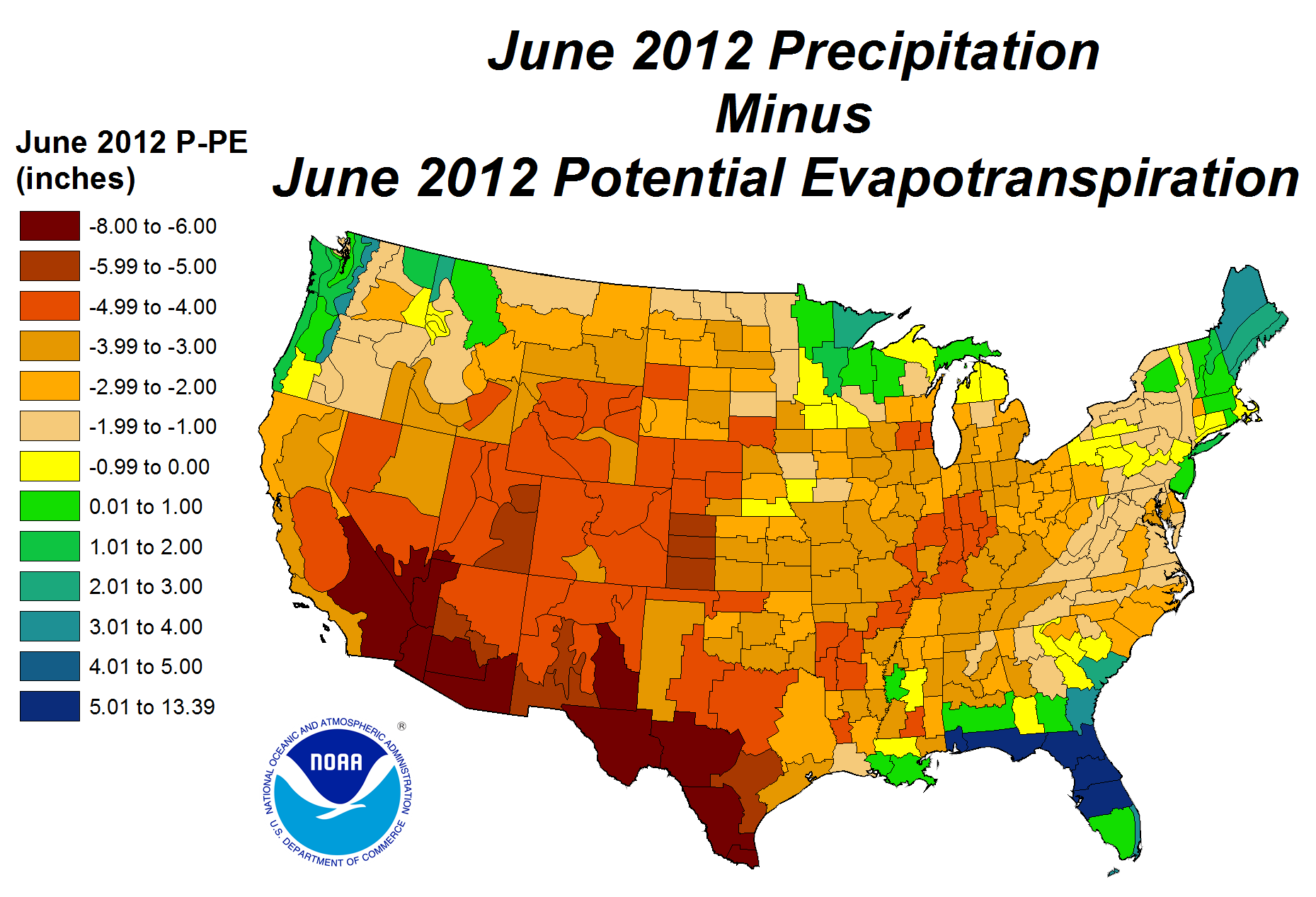
During June 2012, temperatures were much above normal across much of the country from the Southwest to the Great Lakes, resulting in potential evapotranspiration (PE) values which exceeded four inches across most of the country except the Pacific Northwest and far west coast. Precipitation (P) amounts were well below normal — less than four inches in most areas — resulting in P minus PE values which went strongly negative and further sapped soil moisture reserves, stressed crops and other vegetation, and shrank streams. Even if normal precipitation amounts had occurred, it would not have been enough to meet PE demand in most areas.
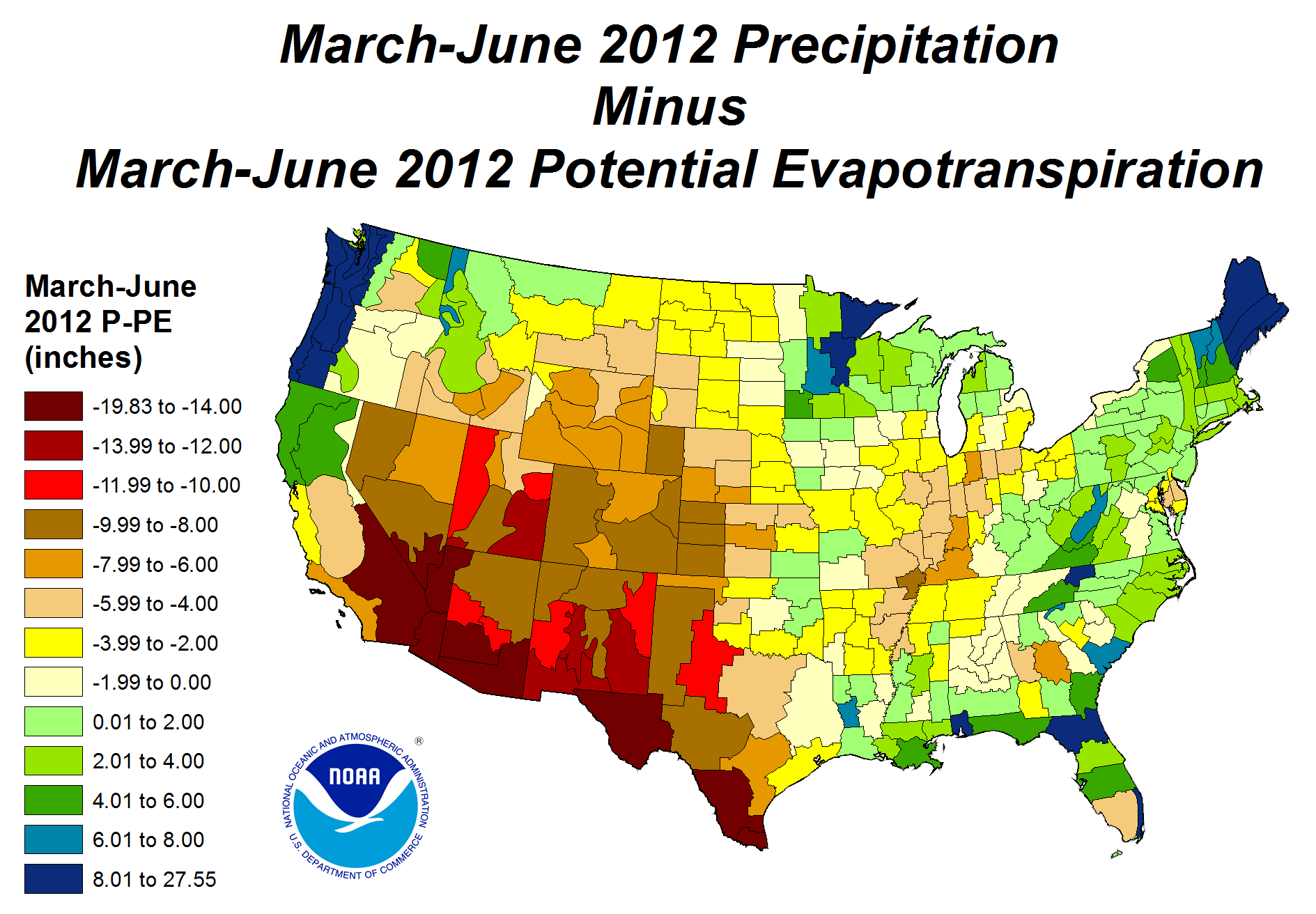
The hardest-hit areas (as measured by pasture, soil moisture impacts) are the Southern to Central Rockies, Central Plains, and Ohio Valley. These areas have had the least precipitation and smallest percent of normal precipitation during March-June 2012. With the unusual warmth of the last four months, PE during March-June has been excessive. The precipitation deficits and extra PE during this season have sent P minus PE values well into negative territory during the important growing season in America's agricultural heartland. If normal precipitation had fallen during this time, P minus PE values would have been positive for the agricultural areas along and east of the Mississippi River, providing support for the spring crops.
Standardized Precipitation Index
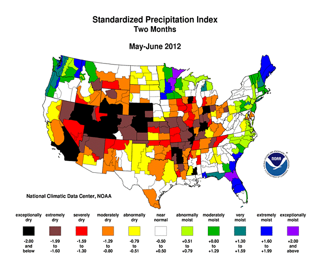
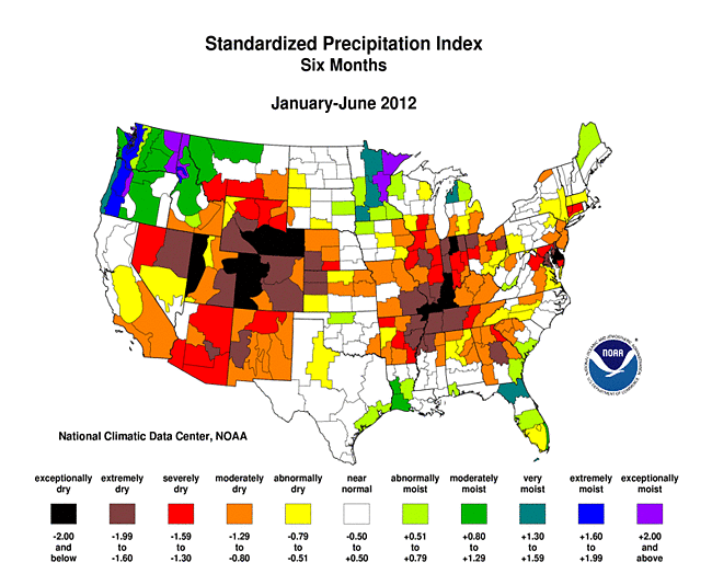
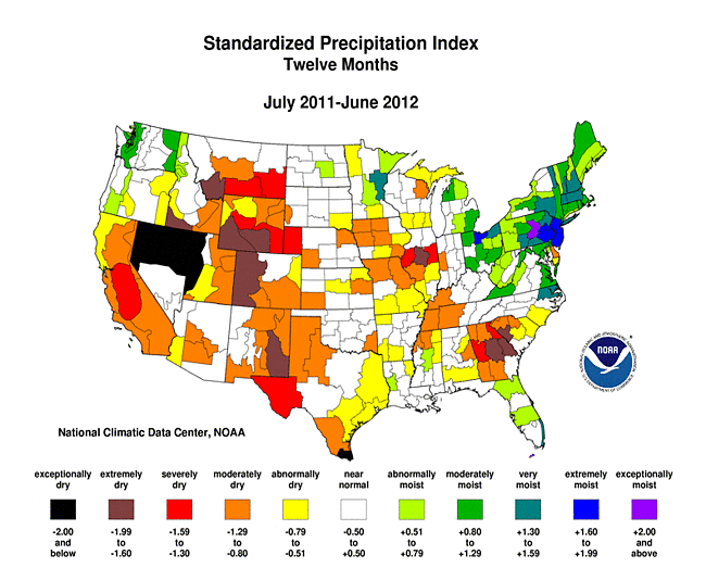
The Standardized Precipitation Index (SPI) measures moisture supply. The SPI maps here show the spatial extent of anomalously wet and dry areas at time scales ranging from 1 month to 24 months.
 |
 |
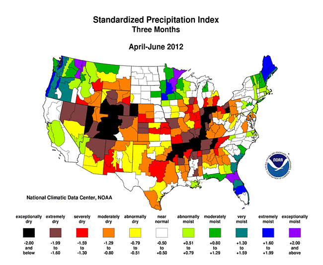 |
Tropical Storm Debby dumped widespread 10-plus inch rainfall over Florida in June, with local amounts over 20 inches. This deluge was enough to neutralize long-term deficits that had built up over the previous 24 months. Moist conditions dominate at almost all time scales in the Pacific Northwest, Upper Mississippi Valley, and northern New England. But for the rest of the country, dry conditions dominate across much of the West at the 1- to 12-month time scales, across much of the Great Plains from 1 to 3 months, in the Midwest and Mid-Mississippi Valley to Central Plains from 1 to 6 months, and parts of the Midwest at 9 to 12 months. Parts of the Southeast are dry at the 1- to 6-month time scales, with core areas in the Southeast dry at 9 to 12 months. The Southwest is dry at all time scales except 9 months. The Southern Plains has areas of dryness at 1 to 3 months and again at 12 months. Widespread dryness stretches from the Southwest to the Southeast at 24 months, while widespread wet conditions are evident across the Northwest to Northeast at that same time scale.
 |
 |
 |
Agricultural and Hydrological Indices and Impacts
 |
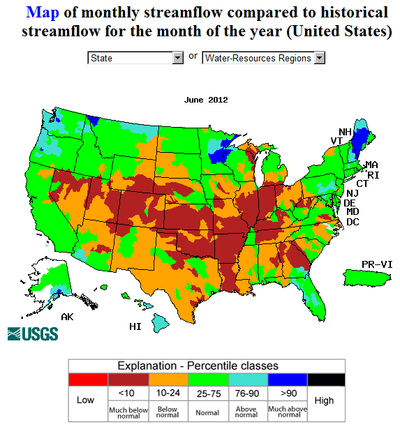 |
Drought conditions were reflected in numerous agricultural, hydrological, and other meteorological indicators, both observed and modeled:
hydrological:
- USGS (U.S. Geological Service) observed streamflow;
- NOAA Climate Prediction Center (CPC) modeled runoff anomalies and percentiles;
- VIC (University of Washington Variable Infiltration Capacity macroscale hydrologic model) 1-, 2-, 3-, and 6-month runoff percentiles;
- NLDAS (North American Land Data Assimilation System) modeled streamflow anomalies and percentiles;
- NLDAS model runoff anomalies and percentiles;
- USGS groundwater observations (real-time network, climate response network, total active network);
- USDA reservoir storage as percent of capacity;
agricultural:
- USDA (U.S. Department of Agriculture) observed soil moisture conditions, departures and percentiles, and comparison to 5-year average and 10-year average;
- the Palmer Crop Moisture Index (CMI), which intensified during the month in the West, Great Plains, Midwest, and parts of the Deep South (weeks 1, 2, 3, 4, 5);
- CPC modeled soil moisture anomalies and percentiles for the end of the month, and soil moisture anomaly change compared to previous month;
- CPC's Leaky Bucket model soil moisture percentiles;
- NLDAS modeled soil moisture percentiles for the top soil layer and total soil layer;
- VIC modeled soil moisture percentiles, and soil moisture percentile change compared to previous month;
- USDA observed pasture and rangeland conditions;
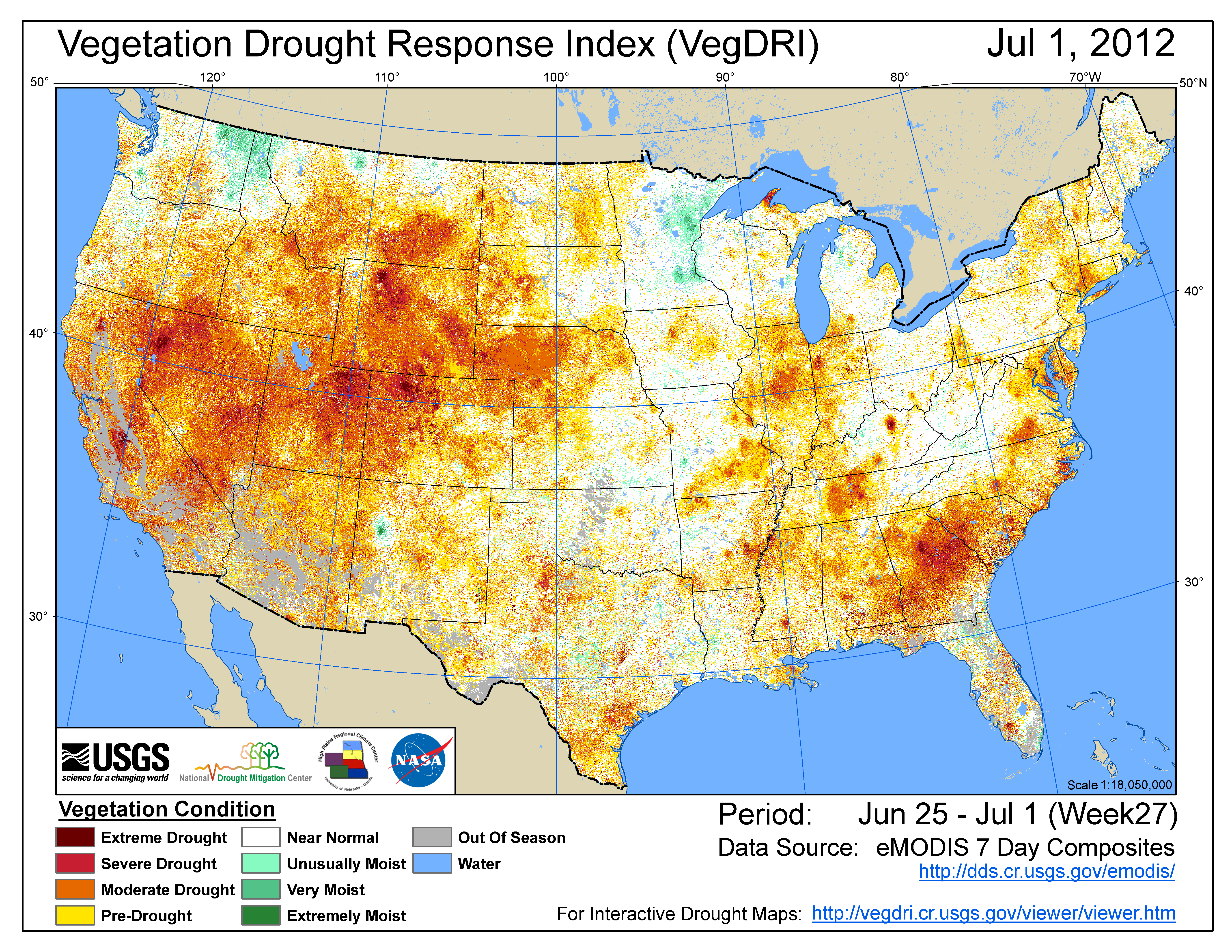
- Vegetation Drought Response Index (VegDRI);
- the NOAA/NESDIS satellite-based Vegetation Health Index (VHI);
- the USGS agro-hydrologic model (Soil Water Index, Water Requirement Satisfaction Index);
meteorological:
- total precipitation (plotted by the USGS, NOAA National Weather Service [NWS], and NOAA High Plains Regional Climate Center [HPRCC]);
- percent of normal precipitation and precipitation percentiles (CPC, NWS, HPRCC station observations, Leaky Bucket model);
- NCDC statewide precipitation ranks;
- USGS number of days with precipitation and maximum number of consecutive dry days;
- temperature departures from normal (HPRCC) and temperature percentiles (CPC, Leaky Bucket);
- NCDC statewide temperature ranks; and
- number of record warm daily low temperatures, record daily high temperatures, record daily low temperatures, and record cool daily high temperatures, and all-time record high temperatures, set during the month (from NCDC's daily records analysis).
Regional Discussion
June 2012 was characterized by a mixed rainfall pattern across the Hawaiian Islands. Abnormally dry to moderate drought conditions expanded into the northern islands this month, but otherwise the USDM depiction this month was little changed from last month. Longer-term conditions continued drier than normal (last 2, 3, 6, 12, 24, and 36 months), especially for the southern islands.
In Alaska, June 2012 was generally drier than normal in the northern and northwestern areas with a mixed pattern at central and southern stations. This precipitation pattern is evident at short time scales (2, 3, and 6 months), while at longer time scales a dry pattern at interior stations becomes evident (12, 24, and 36 months). Several large wildfires broke out during the month (15th, 20th, 25th, 26th) in the northern and central sections of the state. An area of abnormal dryness was added to the northern areas on the USDM map.
Much of Puerto Rico was drier than normal during June, especially in the eastern half of the island. The June dryness also shows up in the rainfall anomaly map for the last two months. The dry anomalies become more focused into the southeastern area at longer scales (3 and 6 months, and water year to date). With streamflow near normal, the July 3rd USDM map had no drought or abnormally dry areas on the island.
 |
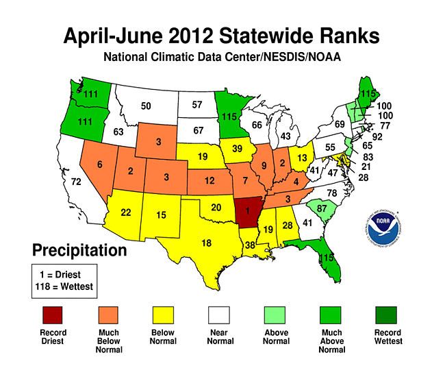 |
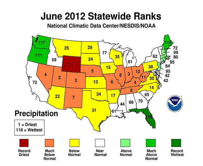
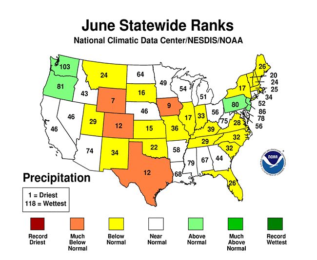
Over a third of the U.S. was very dry (the driest ten percent of the historical record) during June 2012. By this measure, this month was the third driest June in the 118-year record. On a statewide basis, June 2012 ranked in the top ten driest Junes for eleven states from the West to Ohio Valley. Wyoming had the driest June in the 1895-2012 record, Colorado and Utah ranked second driest, and Indiana third driest. Fifteen other states from the West to Mid-Atlantic Coast ranked in the driest third of the historical record. A similar spatial pattern of dryness is evident at the three month time scale — four states ranked in the top ten driest category for April-June in the West, and six in the Ohio-Tennessee-Mid-Mississippi Valley. Arkansas had the driest April-June, Indiana and Utah ranked second driest, and Colorado, Wyoming, and Tennessee were third driest. Thirteen other states ranked in the driest third of the historical record.
 |
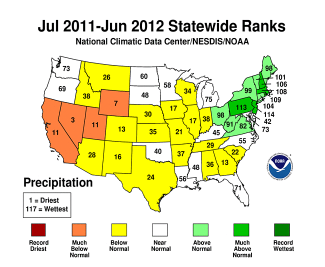 |
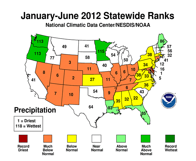
Three centers of dryness appear at the six month time scale — the same two that are evident at three months (West and Ohio-Tennessee Valley) plus the Mid-Atlantic. Delaware had the driest January-June on record with Maryland at fifth driest. The dryness in Delaware was prolonged, with the state also having the driest November-June, October-June, and September-June. In the Midwest, six states (Arkansas, Illinois, Indiana, Ohio, Kentucky, and Tennessee) fell in the top ten driest category, as did six states in the West (Colorado, Arizona, Wyoming, New Mexico, Utah, and Nevada). Colorado had the second driest January-June, but the driest May-June. In total, 14 states ranked in the top ten driest category for January-June, and another 14 were in the driest third of the historical record. At the 12 month time scale, dryness dominates in the western states and extends its tentacles into the South and Midwest. July 2011-June 2012 ranked in the top ten driest category for Nevada (third driest) and Wyoming (seventh driest). Nineteen other states ranked in the driest third of the historical record.
 |
 |
 |
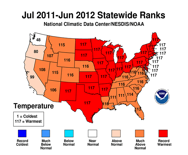 |
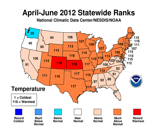
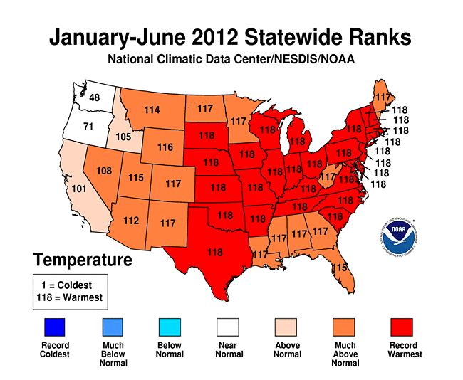
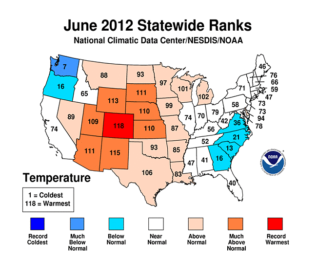
The dryness has been accompanied by abnormally warm temperatures at all time scales. June 2012 ranked as the warmest June in the 1895-2012 record for Colorado, in the top ten warmest category for seven nearby states, and in the warmest third of the historical distribution for twelve additional ones. Two states (Colorado and Kansas) had the warmest April-June, 25 more were in the top ten warmest category, and 19 more ranked in the warmest third of the historical distribution. Twenty-eight states were record warm for January-June 2012 and 26 were record warm for July 2011-June 2012. The rest of the Lower 48 States fell in the top ten warmest or warmest third categories — except Washington and Oregon for January-June and Washington for July-June.
As noted earlier, excessive heat increases evapotranspiration and exacerbates drought. The combination of third driest and fifth warmest April-June gave Wyoming the most severe April-June averaged Palmer Z Index in the 1895-2012 record. The driest and warmest May-June virtually tied 2012 with 2002 as the most severe May-June averaged Palmer Z Index for Colorado. For Arkansas, the driest and fourth warmest April-June tied 2012 with 1925 for the most severe averaged April-June Palmer Z Index. This record short-term drought resulted in a rapid expansion of overall drought conditions for these three states. For Arkansas and Wyoming, the 2012 conditions were preceded by a period of non-drought conditions. But for Colorado, drought has been ongoing for over a year. During the last three months, drought has expanded rapidly in Colorado, but it has not reached the magnitude of the 2002 record drought as monitored by the USDM or PHDI. Other states, such as Georgia and New Mexico, have had prolonged drought but some have not experienced extreme conditions in the last three months (31st warmest and 41st driest April-June for Georgia) while others have (third warmest and 15th driest April-June for New Mexico)
Corn and Soybean Belt
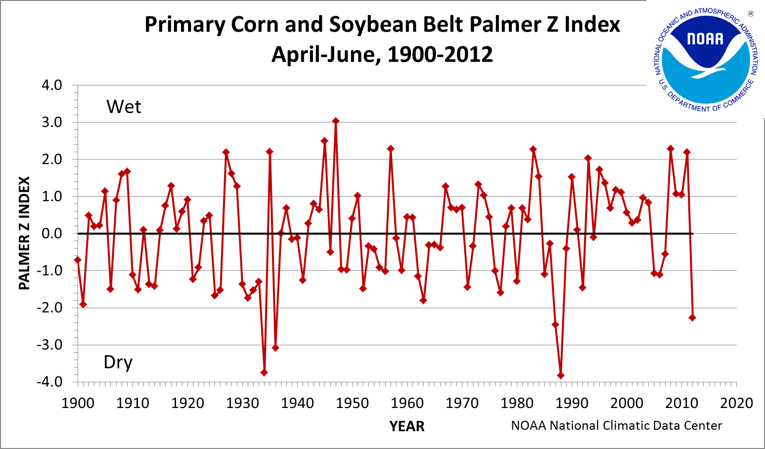
The primary corn and soybean agricultural belt has been especially hard hit by drought the last three months. This region, collectively, has experienced the seventh warmest and tenth driest April-June in 2012, resulting in the fifth most severe Palmer Z Index. Topsoil has dried out and crops, pastures, and rangeland have deteriorated at a rate rarely seen in the last 18 years, yet drought barely registers for the region on the longer-term PDSI because the previous several years have been very wet (in fact, 2008, 2010, and 2011 all rank in the top ten wettest category for April-June). The last time the April-June Palmer Z Index was this dry was 1988, which had the most severe Palmer Z Index and the driest and twelfth warmest April-June. The second, third, and fourth most severe April-June Palmer Z Index occurred in 1934, 1936, and 1987, respectively.
Western U.S.
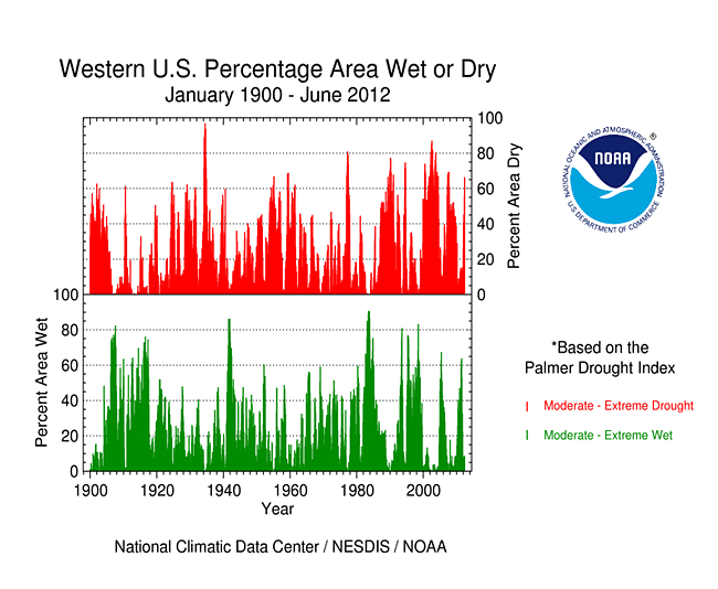
With the Pacific storm track near the Canadian border, subtropical high pressure dominating the weather, and a weak start to the summer monsoon, above-normal rain fell in the Pacific Northwest but much of the western U.S. was left with little significant precipitation this month. Drier-than-normal weather has dominated from the Southwest and intermountain basin to the Central and Southern Rockies for the water year to date (October-present), as reflected in low elevation as well as high elevation (SNOTEL) precipitation, especially for the southern half of the West. Reservoir storage was below average, statewide, in many southern states but near to above average to the north. Hot, dry, windy weather contributed to many wildfires across the West. According to the USDM, 64 percent of the West was experiencing moderate to exceptional drought at the end of June, an 11 percent increase compared to May. While extensive, drought in 2012 has not been as severe or widespread, westwide, as it was in 2002-2005. The Palmer Drought Index percent area statistic was about 66 percent, reflecting a remarkable rise over the last six months.
 |
 |
Historical Analogs
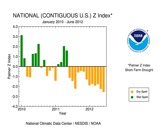
The persistent warmth and dryness of the last couple years have been so severe that the nationally-integrated Palmer Z Index has been consistently negative (water demand outstripping water supply) for the last 13 consecutive months. This is largely behind the rapid expansion of drought this year which has led to the largest percent area in moderate to exceptional drought in the 12-year USDM record and largest moderate to extreme drought area (based on the Palmer Drought Index) since the 1950s. In 2012, about 56 percent of the contiguous U.S. was in moderate to extreme drought at the end of June. The last time drought was this extensive was in December 1956 when about 58 percent was in moderate to extreme drought.
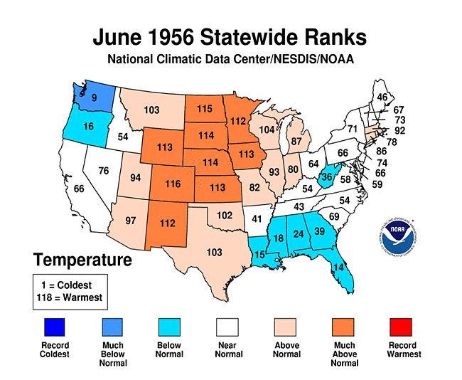
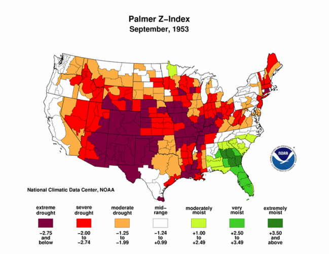
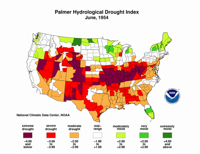
Historical analogs to the current drought can be determined by comparing the spatial pattern and intensity of various climate indicators using statistical tools such as the correlation coefficient and mean absolute difference. When applied to the temperature pattern for June 2012, the closest match is June 1956. June 1956 is a close match for the dry areas of June 2012 based on precipitation. For the Palmer Z Index, June 1956 matches June 2012 well in the West and Great Plains, but not in the Ohio to Mid-Mississippi Valley. November 1999 is the closest match, followed by December 1939 and September 1953. The overall spatial pattern of Palmer Z Index drought in June 1988 matches in some areas (Midwest, parts of the Plains and Rockies), but is significantly different in other areas (Southwest, Northeast, Southeast). For the long-term drought spatial pattern (PHDI), several months in the 1950s are the closest historical match to June 2012, with June 1954 being a good representative. In summary, several of these indicators suggest that the 2012 drought is similar to the 1950s drought in extent, pattern, and intensity, although not in duration.
 |
 |
 |
 |
 |
 |
 |
 |
A more detailed drought discussion, provided by the NOAA Regional Climate Centers and others, can be found below.
West — Upper Colorado River Basin — Pacific Islands
As noted by the Southeast Regional Climate Center, for the first time since October, mean temperatures in June were below average across most of the Southeast region. The greatest departures were found across central and eastern portions of Georgia and the Carolinas, where monthly temperatures were between 2 and 3 degrees F (1.1 to 1.6 degrees C) below average. In contrast, temperatures were generally above average across Alabama, Puerto Rico, and the U.S. Virgin Islands. Monthly precipitation was below normal across much of the Southeast in June, except across parts of northern Florida and the northern Gulf Coast, where two separate weather systems contributed to monthly rainfall totals between 200 and 600 percent of normal. Between the 23rd and 26th of the month, Tropical Storm Debby dumped between 10 and 30 inches (254 and 762 mm) of rain across a large portion of the Florida Panhandle from near Apalachicola to Jacksonville. Rainfall totals of up to 10 inches (254 mm) were reported as far south as Tampa Bay, which recorded its wettest June on record, and as far north as southeastern Georgia. Conversely, much of the Southeast was dry in June, with monthly precipitation totals between 25 and 75 percent of normal. The driest locations were found across central Alabama, eastern North Carolina, and across much of Puerto Rico and the U.S. Virgin Islands, where monthly precipitation was less than 25 percent of normal. San Juan, PR, which recorded its warmest month on record, also recorded its driest June on record with 0.16 inch (4.1 mm) of rainfall, while Saint Thomas, USVI, recorded its second driest June on record with just 0.08 inch (2 mm) of rainfall. The rainfall from Debby helped eliminate drought conditions across Florida, particularly in the Panhandle region which had been under extreme drought conditions for several months. Some improvement was also noted across central and eastern sections of the Carolinas. By the end of June, about 50 percent of the Southeast was in drought (according to the USDM), down from about 75 percent at the beginning of the month. Corn planted early in the season showed signs of damage due to the dry weather across Florida prior to Debby, while in Georgia, corn yields were estimated to be down 10 to 15 percent due to increased cloud cover and less solar radiation during the month. The hot weather at the end of the month contributed to poor air quality across much of the Southeast, particularly across parts of Georgia (including metropolitan Atlanta) where code purple advisories were issued for ozone. At these levels, which have not been reached in the Atlanta area since 2007, even healthy individuals may experience serious health effects.
As explained by the Southern Regional Climate Center, for the most part, June was a relatively average month where temperatures are concerned. With a few small exceptions, June was a relatively dry month with much of the region receiving less than average precipitation totals. The driest area of the region proved to be southern and southeastern Texas, where a majority of stations received only 0 to 25 percent of normal precipitation. This was also the case for much of central Tennessee, western Arkansas, north central Louisiana, and south central Mississippi. With all six states receiving less than normal precipitation in June, drought conditions throughout the Southern region deteriorated. Much of Tennessee is now experiencing a severe (D2) drought. In Arkansas, conditions have worsened from moderate to severe drought, with pockets of extreme drought in all areas of the state. Central Texas has also been downgraded from no drought and moderate (D1) drought to moderate (D1) and severe drought (D2). In Louisiana, northern parishes are now experiencing moderate (D1) drought as well. This is also the case for eastern Tennessee and much of central and eastern Oklahoma. Texas farmers harvested their summer crops in early June, and they generally received a better yield than expected, even in West Texas where rain was scarce. Livestock was reported to be in fair condition as well, according to the Texas AgriLife Extension Service. Ranchers noted healthy grasslands provided food for cattle while the spring rains refilled stock tanks. However, the looming hot and dry summer conditions have begun to worry farmers and ranchers. (Information provided by the Texas State Climate Office)
As summarized by the Midwest Regional Climate Center, June temperatures were slightly above normal for most of the Midwest while June precipitation was above normal for the upper Midwest but well below normal for the southern two-thirds of the region. Rainfall totals were less than half of normal June totals for most of the southern two-thirds of the Midwest and between 10 and 25 percent of normal in scattered pockets of several states. Drought conditions expanded and intensified in the Midwest in June. Midwest areas in drought quadrupled during the month and areas in Severe Drought increased from less than 2 percent to more than 15 percent of the region. Extreme Drought was introduced to over 5 percent of the Midwest in June. Farmer reports of pasture conditions and row crop conditions deteriorated as the month progressed with many areas in the southern Midwest reporting the poorest June conditions since 1988.
As noted by the Northeast Regional Climate Center, precipitation during June averaged 98 percent of normal overall. However, like last month, rainfall was not evenly distributed throughout the Northeast. With 176 percent of normal, Maine had its 4th wettest June in 118 years, while West Virginia experienced its 11th driest June since 1895. A look at the first six months of 2012 has Delaware with only 53 percent of the January through June normal precipitation total while Maine had 112 percent. Maine was the only state in the Northeast to average wetter-than-normal during this period. It was the driest January through June since 1895 in Delaware and the 5th driest in Maryland. As of June 26, the USDM indicated a few areas of abnormally dry conditions, including most of West Virginia, and parts of northern New York and Vermont. Moderate drought (D1) conditions were expanded during the month to include a larger area around the Chesapeake Bay in eastern Maryland.
As explained by the High Plains Regional Climate Center, there were major changes to the USDM this month as hot and dry conditions prevailed over the majority of the region. Drought conditions developed or worsened in each state in the region over the past month. At the end of the month nearly 84 percent of the region had a D0-D4 designation (abnormally dry to exceptional drought conditions), while at the end of last month the figure was 66 percent. The expansion of the D2-D4 range (severe to exceptional drought conditions) was quite impressive as it jumped from 8 percent coverage at the end of May to 47 percent coverage at the end of June. The entire state of Colorado had D1 designation (moderate drought conditions) or higher, and by the end of the month nearly 46 percent of the state was experiencing D3 (extreme drought conditions). D3 conditions also expanded into southwestern Wyoming and western Kansas. The hot and dry weather this month created dangerous fire weather conditions in Colorado, Wyoming, Nebraska, and South Dakota. Although some fires started early in June, the record-setting heat, lack of rainfall, and windy conditions during the last week of the month contributed to the explosiveness of many fires. It was during this time that much of Colorado had multiple days at or above 100 degrees F (37.8 degrees C). While many of the fires were caused by lightning, the causes of others are still under investigation. Unfortunately, the fires have been incredibly destructive as hundreds of thousands of acres have burned and at this point, countless structures have been affected as conditions at the end of the month were still too dangerous to perform damage assessments in some areas. The fires have had impacts in many different sectors ranging from tourism, to water resources, to energy. Many communities have cancelled 4th of July fireworks shows, according to 9NEWS in Denver. As many of these fires continue to burn and new fires start, the final toll of these fires is yet to be determined.
As summarized by the Western Regional Climate Center, the Southwest experienced record heat and numerous destructive blazes this month. Utah, Montana, Colorado, Idaho and Wyoming were among the most affected by large fires ignited and record temperatures. In contrast, the Pacific Northwest experienced anomalously cool and wet conditions. Fire activity has been below recent averages in acreage (85-90 percent) and number (about two-thirds), but the fires that have occurred were in populated areas with valuable property. Dry and windy conditions dominated the Southwest, allowing for severe fire weather to persist throughout the month. June is normally the driest month in the desert Southwest, and many locations in Southern California, Nevada, Utah, and western Arizona received no measurable precipitation for the month. Salt Lake City received only a trace of precipitation, the third driest June in a record dating back to 1928. Localized thunderstorms brought a few days of light moisture to New Mexico, Southern Arizona, and Colorado throughout the month. Further west, drought conditions continued to worsen in Hawaii, with leeward locations most affected. Lihue, Kauai received only 0.45 in (11.43 mm) this June, the third driest June on the stations record that began in 1950. Kona, Hawaii received 0.21 in (5.3 mm), 21 percent of normal for June.
Pacific Islands: According to reports from National Weather Service offices, the Pacific ENSO Applications Climate Center (PEAC), and partners, conditions varied across the Pacific Islands.

On other Pacific Islands (maps — Micronesia, Marshall Islands, basinwide), June was drier than normal for Majuro, but near to above normal for the rest of the stations. Total rainfall for the last 12 months (July 2011-June 2012) was near to above normal for all stations.
| Station Name** | Jul 2011 | Aug 2011 | Sep 2011 | Oct 2011 | Nov 2011 | Dec 2011 | Jan 2012 | Feb 2011 | Mar 2012 | Apr 2012 | May 2012 | Jun 2012 | Jul 2011-Jun 2012 |
| Chuuk | 125% | 144% | 118% | 97% | 136% | 125% | 57% | 181% | 107% | 40% | 173% | 131% | 118% |
| Guam IAP | 203% | 102% | 129% | 135% | 83% | 103% | 162% | 94% | 215% | 121% | 224% | 107% | 133% |
| Kapingamarangi | 147% | 162% | 107% | 57% | 81% | 124% | 109% | 71% | 121% | 102% | 143% | 179% | 120% |
| Koror | 152% | 155% | 266% | 122% | 62% | 97% | 36% | 126% | 121% | 120% | 122% | 95% | 125% |
| Kosrae | 87% | 122% | 104% | 154% | 95% | 174% | 65% | 185% | 60% | 84% | 86% | 99% | 107% |
| Kwajalein | 104% | 144% | 111% | 125% | 130% | 84% | 134% | 114% | 84% | 68% | 161% | 117% | 118% |
| Majuro | 131% | 108% | 115% | 115% | 119% | 91% | 107% | 65% | 194% | 97% | 59% | 81% | 106% |
| Pago Pago | 42% | 72% | 29% | 137% | 157% | 75% | 61% | 98% | 131% | 90% | 126% | 115% | 97% |
| Pohnpei | 92% | 138% | 115% | 77% | 123% | 110% | 82% | 138% | 98% | 45% | 115% | 100% | 101% |
| Saipan | 96% | 93% | 68% | 140% | 57% | 110% | 77% | 183% | 35% | 33% | 166% | 118% | 98% |
| Yap | 138% | 129% | 156% | 101% | 112% | 116% | 33% | 117% | 185% | 89% | 142% | 99% | 120% |
** Clicking on the station name will reveal a climatology graph of the normal monthly rainfall.

[top]
State/Regional/National Moisture Status
A detailed review of drought and moisture conditions is available for all contiguous U.S. states, the nine standard regions, and the nation (contiguous U.S.):
| northeast u. s. | east north central u. s. | central u. s. |
| southeast u. s. | west north central u. s. | south u. s. |
| southwest u. s. | northwest u. s. | west u. s. |
| Contiguous United States |
[top]
Drought Indicators
- Palmer Drought Indices
- Standardized Precipitation Index
- long-term (36 to 60 month) percent of normal precipitation maps
- airport station percent of normal precipitation maps
- statewide precipitation rank maps
- Cooperative station percent of normal precipitation maps
- percent of average maps for the SNOTEL stations in the western mountains provided by the Western Regional Climate Center
- hydrologic year precipitation
- snow water equivalent of snowpack
- satellite-based observations of vegetative health
- National Weather Service model calculations of soil moisture, runoff, and evaporation
- National Weather Service model calculations of soil moisture using the Leaky Bucket Model
- Midwest Regional Climate Center model calculations of soil moisture
- topsoil moisture conditions observed by the USDA and mapped by the Climate Prediction Center
- pasture and range land conditions observed by the USDA and mapped by the Climate Prediction Center
- streamflow maps maintained by the USGS
[top]
Contacts & Questions
 NOAA's National Centers for Environmental Information