Contents Of This Report:
|
|
National Drought Overview
|
|
[top]
Detailed Drought Discussion
Overview
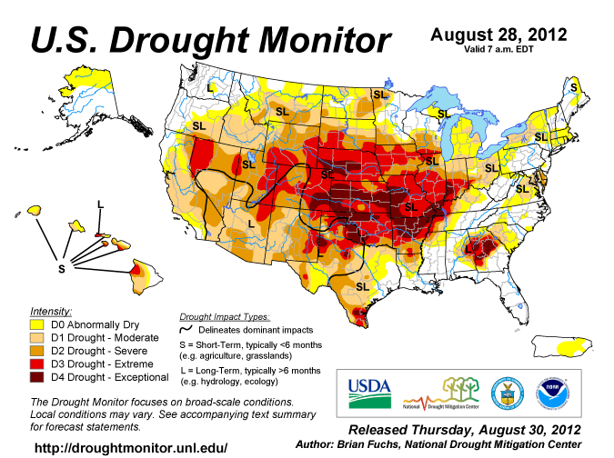
August 2012 was another warmer-than-average month (16thwarmest August on record, based on data back to 1895), with precipitation near average (57th driest August), when weather conditions are averaged across the country. Cool fronts swept across the Midwest and East (weeks 1, 2, 3, 4, 5) while a strong high pressure system (High, or upper-level ridge) kept its stranglehold over much of the West, resulting in a monthly pattern of anomalous warmth in the West and Northeast and below-normal temperatures in the Midwest and Southeast. Descending air ("subsidence") associated with the High inhibited precipitation in the Northwest to Central Plains states, while passing fronts and the remains of Hurricane Isaac triggered areas of rain in the East and South and monsoon showers brought rain to the Southwest (weeks 1, 2, 3, 4, 5). The dry weather, in combination with increased evaporation caused by the record heat, expanded drought conditions in the West and intensified drought conditions in the Plains. Nationally, the moderate-to-exceptional (D1-D4) drought footprint remained about the same at 53 percent of the country, compared to last month, while the percentage in the abnormally dry to exceptional drought category increased to about 78 percent. About 19 percent of the country was in the worst drought categories (D3-D4, extreme to exceptional drought), fractionally higher than last month. The Palmer Drought Index, whose data base goes back 113 years, is relied upon for drought comparisons before 2000. The August 2012 Palmer value of 55 percent in moderate to extreme drought is a decrease of about 3 percent compared to last month, but the percent area in severe to extreme drought increased to about 39 percent, confirming that the drought has intensified.
By the end of the month, the core drought areas in the U.S. included:
- a large area of moderate (D1) to exceptional (D4) drought stretching from the central Rockies, across the central and southern Plains, into the Mid-Mississippi and Ohio valleys and southern Great Lakes;
- a contracting area of moderate to exceptional drought in the Southeast;
- an area of moderate to severe (D2) drought in the Mid-Atlantic, with areas of moderate drought in the Northeast;
- an expanding area of moderate to extreme drought across much of the West; and
- much of Hawaii, where moderate to extreme drought persisted.
Isaac: The remnants of Hurricane Isaac brought beneficial rain to the Lower to Mid Mississippi Valley drought areas during the waning days of August (August 30th and 31st). Isaac's rain moved into the Ohio Valley and became absorbed into a cool front during the first few days of September (September 1st, 2nd, 3rd), improving drought conditions across parts of the Midwest (USDM for September 4th vs. August 28th). While Isaac's rains reduced the percent area of the Midwest in extreme to exceptional drought from 33 percent in late August to 14 percent in early September, thus reducing the severity of drought here, the rains were not enough to erase months of deficits, with the percent area in moderate to exceptional drought remaining fairly constant (reduced from 65 percent to 63 percent), and the Midwest improvement does not show up in the end-of-August monthly drought indicators (such as the Palmer Drought Index, streamflow, etc.). Isaac had little effect on the national drought picture, with roughly the same percent area of the U.S. in the various USDM drought categories before as after. This is due to drought worsening and expanding in the Plains and West to counterbalance the improvement in the Midwest.
Palmer Drought Index
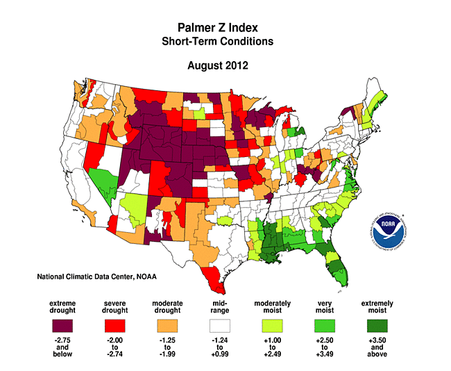
The Palmer drought indices measure the balance between moisture demand (evapotranspiration driven by temperature) and moisture supply (precipitation). The Palmer Z Index depicts moisture conditions for the current month, while the Palmer Hydrological Drought Index (PHDI) and Palmer Drought Severity Index (PDSI) depict the current month's cumulative moisture conditions integrated over the last several months.
 |
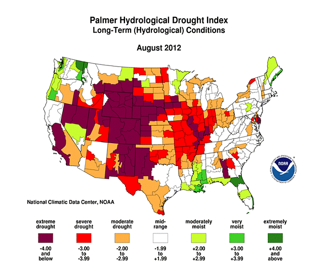 |
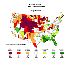
By August 31st, rain from frontal passages had improved short-term drought conditions (as seen on the Palmer Z Index map) in parts of the Midwest and Southeast, decreasing the intensity of long-term drought conditions there (PDSI from end of August compared to end of July). Rains from Isaac had cut into the drought area in Arkansas, but continued hot and dry weather intensified drought conditions (both short-term [Z Index] and long-term [PHDI] conditions) across much of the Plains and West. August dryness (Palmer Z Index map) reduced the long-term wet conditions (PDSI from end of August compared to end of July) in the Pacific Northwest. The August 2012 PHDI map also reflects the long-term nature of the drought conditions. The Z Index and PHDI maps in combination show that precipitation brought relief to parts of the Southeast and Midwest drought areas, and reduced precipitation shrank long-term wet areas in the Northwest, but for much of the rest of the country — drier-than-normal weather persisted over the existing drought areas.
Palmer Drought Model Potential Evapotranspiration
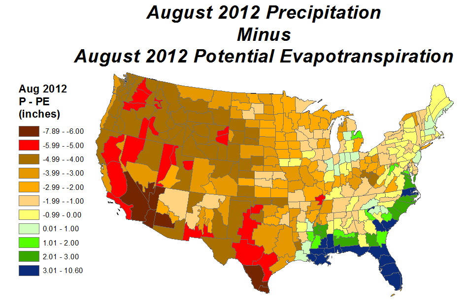
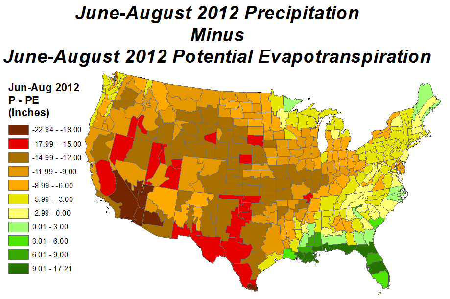
During August 2012, temperatures were much above normal across the western and northeastern U.S., but cooler from the Great Plains to the Midwest and Southeast. This helped reduce the amount of potential evapotranspiration (PE, or natural water demand) in the eastern parts of the Primary Corn and Soybean agricultural belt. But the amount of precipitation (P, or water supply) that fell was still not sufficient to meet the PE demand in most parts of the country, so the net difference — water supply minus water demand (August P minus PE) — was still negative across much of the nation. This continued to sap soil moisture reserves, stress crops and other vegetation, and shrink streams. Even if normal precipitation amounts had occurred, it would not have been enough to meet PE demand in most areas.
The hardest-hit areas (as measured by pasture and soil moisture impacts) were the Rocky Mountain states, Central Plains, and Ohio Valley. The West normally has an arid climate. But even taking that into consideration, these areas have had anomalously warm and dry weather conditions persistently for the summer (June-August temperature, precipitation), growing season (April-August precipitation), and year-to-date (January-August temperature, precipitation). This has had a cumulative impact on water supply versus water demand throughout this period, with widespread persistently negative P minus PE (June-August, April-August, January-August). If normal precipitation had fallen during this time, P minus PE values would still have been negative for the summer (June-August) and growing season (April-August) for these agricultural areas, but the stress on crops would have been far less, and the year-to-date (January-August) P minus PE values would have been positive in the eastern Corn and Soybean belt.
Standardized Precipitation Index
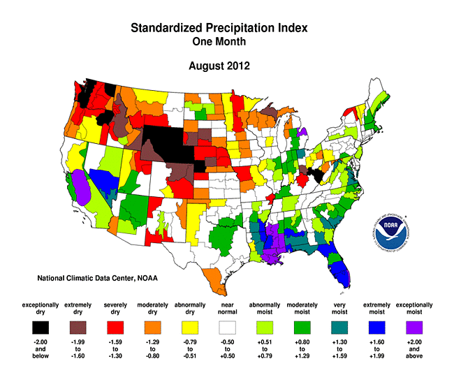
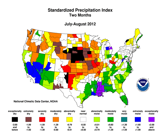
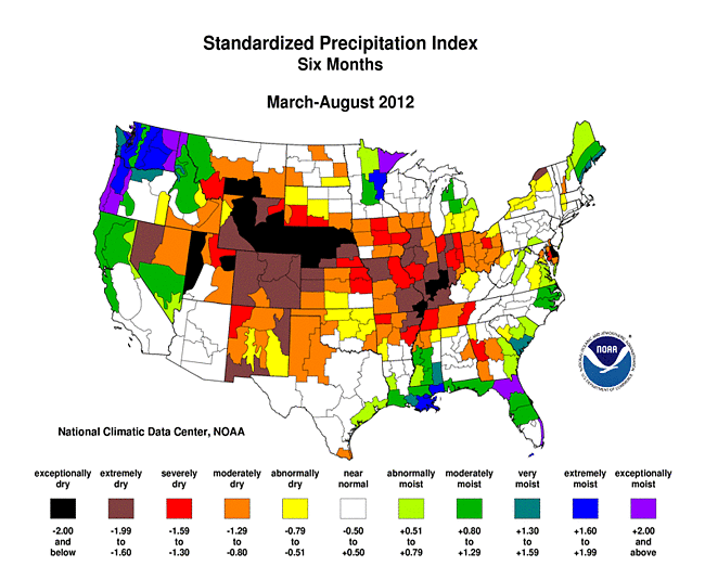
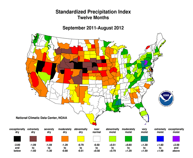
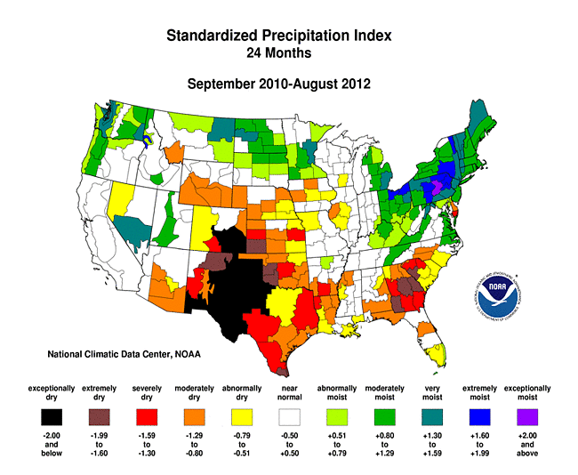
The Standardized Precipitation Index (SPI) measures moisture supply. The SPI maps here show the spatial extent of anomalously wet and dry areas at time scales ranging from 1 month to 24 months.
 |
 |
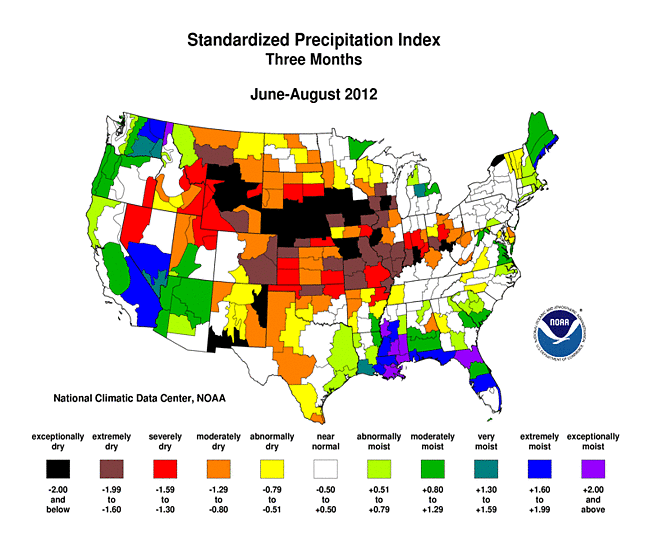 |
The 1-month SPI shows the main area of dryness from the Pacific Northwest to the Central Plains, with other areas dry in the Upper Midwest, Southern Plains to Southern Rockies, and mid-Appalachian Mountains. The Northwest and Northern Rockies are dry at 2 months, but wet conditions dominate there at 3 to 9 months. The summer monsoon in the Southwest is evident from 1 to 3 months, with neutral to dry conditions dominating at 9 to 24 months. Dryness is widespread from the Central Rockies, across the Plains, to the Midwest from 2 to 12 months, especially at 3 to 6 months. The Southeast and parts of the Midwest are wet at 1 to 2 months, but the Southeast wetness becomes limited to the Gulf and Atlantic coasts from 3 to 12 months, with a dry core becoming evident around Georgia at 6 months and stretching to 24 months. Dryness dominates in the Southern Plains at 24 months, while the northern tier states are wet. Wetness extends from New England to the Southern Appalachians at 12 and 24 months.
 |
 |
 |
Agricultural and Hydrological Indices and Impacts
 |
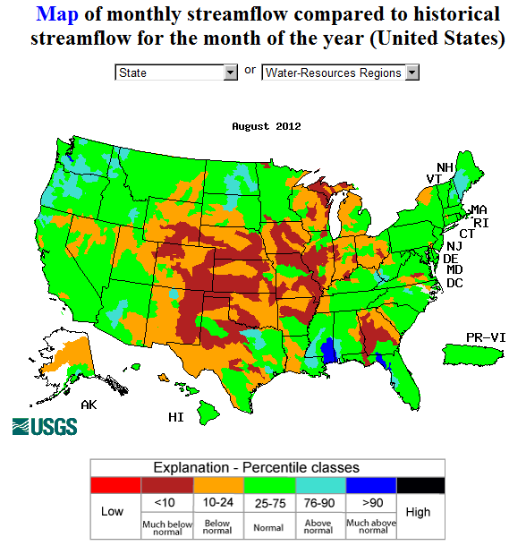 |
Drought conditions were reflected in numerous agricultural, hydrological, and other meteorological indicators, both observed and modeled.
Agricultural:
| Crop | 7/29 | 8/26 | 9/2 | 9/9 |
| Corn | 48% | 52% | 52% | 52% |
| Soybeans | 37% | 38% | 37% | 36% |
| Sorghum | 42% | 50% | 50% | 50% |
| Cotton | 22% | 28% | 28% | 30% |
| Pastures and Rangeland |
57% | 59% | 59% | 58% |
Based on end-of-August (August 26th) U.S. Department of Agriculture reports, 52 percent of the nation's corn crop was rated in poor to very poor condition. This is slightly more than the 48 percent at the end of July. Thirty-eight percent of the national soybean crop was rated poor to very poor (compared to 37 percent a month ago), 50 percent of sorghum (42 percent last month), and 59 percent of the nation's pasture and rangeland (57 percent last month). In some states, nearly all of the pasture and rangeland was rated poor to very poor (Missouri at 99 percent, Nebraska 95 percent, Kansas 92 percent, Illinois 90 percent). In the waning days of the growing season, crop condition changed little during the first two weeks of September, although pastures and rangeland improved in some areas from the rains of Isaac (as of September 9th, Missouri had 92 percent in poor to very poor condition while Illinois dropped to 62 percent and Arkansas to 68 percent [from 84 percent]). But on a national scale, little improvement occurred with 83 percent of corn, 80 percent of soybeans, and 72 percent of cattle still in drought (as of September 4th). The drought has taken a toll on the nation's soil moisture, with virtually all of the topsoil in the Rocky Mountain to Central Plains states short or very short of moisture. The rainfall from Isaac improved soil moisture conditions in Arkansas, Missouri, Illinois, and Indiana during the first week of September.
- USDA (U.S. Department of Agriculture) observed soil moisture conditions, departures and percentiles, and comparison to 5-year average and 10-year average;
- the Palmer Crop Moisture Index (CMI), which improved where it rained in the Southern Plains and Midwest, but deteriorated or stayed the same in the Northern Plains as the month progressed (weeks 1, 2, 3, 4, 5);
- NOAA Climate Prediction Center (CPC) modeled soil moisture anomalies and percentiles for the end of the month, and soil moisture anomaly change compared to previous month;
- CPC's Leaky Bucket model soil moisture percentiles;
- NLDAS (North American Land Data Assimilation System) modeled soil moisture percentiles for the top soil layer and total soil layer;
- VIC (University of Washington Variable Infiltration Capacity macroscale hydrologic model) modeled soil moisture percentiles, and soil moisture percentile change compared to previous month;
- USDA observed pasture and rangeland conditions;
- Vegetation Drought Response Index (VegDRI);
- the NOAA/NESDIS satellite-based Vegetation Health Index (VHI);
- the USGS (U.S. Geological Service) agro-hydrologic model (Soil Water Index, Water Requirement Satisfaction Index);
Hydrological:
- USGS observed streamflow;
- CPC modeled runoff anomalies and percentiles;
- VIC 1-, 2-, 3-, 6-month, and water year to date runoff percentiles;
- NLDAS modeled streamflow anomalies and percentiles;
- NLDAS model runoff anomalies and percentiles;
- USGS groundwater observations (real-time network, climate response network, total active network);
- USDA reservoir storage as percent of capacity;
Meteorological:
- total precipitation (plotted by the USGS, NOAA National Weather Service [NWS], and NOAA High Plains Regional Climate Center [HPRCC]);
- percent of normal precipitation and precipitation percentiles (CPC, NWS, HPRCC station observations, Leaky Bucket model);
- NCDC statewide precipitation ranks;
- USGS number of days with precipitation and maximum number of consecutive dry days;
- temperature departures from normal (HPRCC) and temperature percentiles (CPC, Leaky Bucket);
- NCDC statewide temperature ranks; and
- number of record warm daily low temperatures, record daily high temperatures, record daily low temperatures, and record cool daily high temperatures, set during the month (from NCDC's daily records analysis).
Regional Discussion
August 2012 was characterized by below-normal rainfall across most of the Hawaiian Island stations. Moderate to extreme drought affected 54 percent of the state, about the same as last month. Longer-term conditions continued drier than normal (last 2, 3, 6, 12, 24, and 36 months, year-to-date, and water-year-to-date), especially for the southern islands.
In Alaska, August 2012 was generally drier than normal in the eastern and southern regions and wetter than normal in the west and north. Many central to southeast stations were drier than normal at the 2-month time scale, and dryness extended from central Alaska to the north coast at 6 to 8 months, but otherwise a mixed pattern prevailed (3, 12, 24, and 36 months, and water-year-to-date). An area of abnormal dryness covered the northern areas on the USDM map.
Puerto Rico was drier than normal in a band from the west coast to the central regions, and along much of the east coast, during August and for the last 2 to 3 months. Southern and eastern portions of Puerto Rico have been persistently drier than normal at longer time scales (6 months, year to date, and water year to date). The August 28th USDM map had an area of abnormally dryness in the south central to eastern areas to reflect these rainfall deficits.
 |
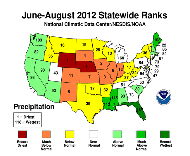 |
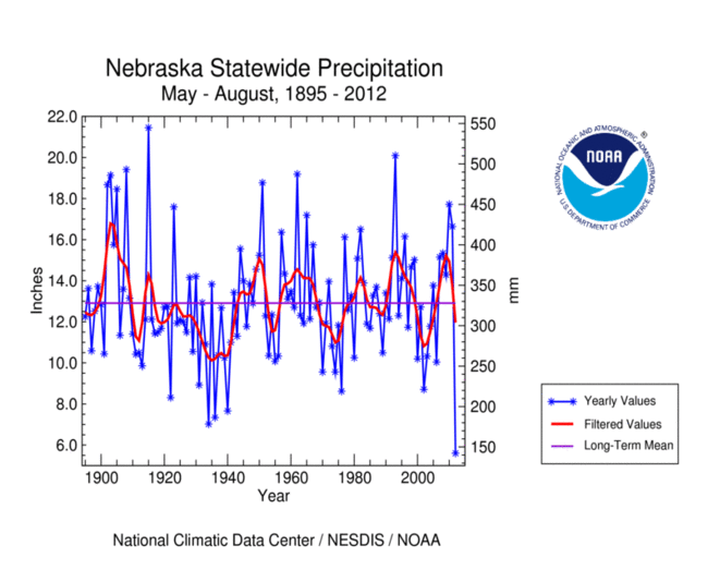
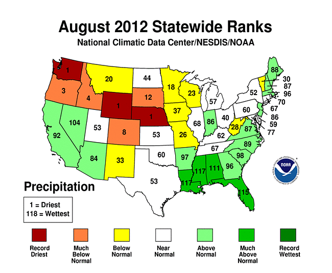
Over a fifth of the U.S. was very dry (the driest ten percent of the historical record) during August 2012. The dryness was partially balanced out by a significant area (9 percent) that was very wet, resulting in a national rank for August 2012 of 57th driest August in the 118-year record. On a statewide basis, August 2012 ranked in the top ten driest Augusts for six states — from the Northwest to the Central Plains — and ranked as the driest August for Nebraska, Washington, and Wyoming. Nine other states ranked in the driest third of the historical record. The spatial pattern of dryness at the three month time scale stretched from the Rocky Mountain states to the Ohio Valley and parts of the Northeast. Again, Nebraska and Wyoming had the driest June-August on record. Six other states had the tenth driest, or drier June-August and 16 other states ranked in the driest third of the historical record.
 |
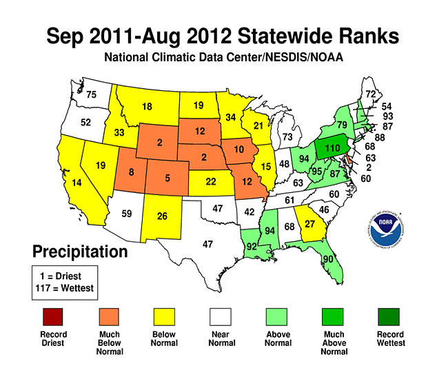 |
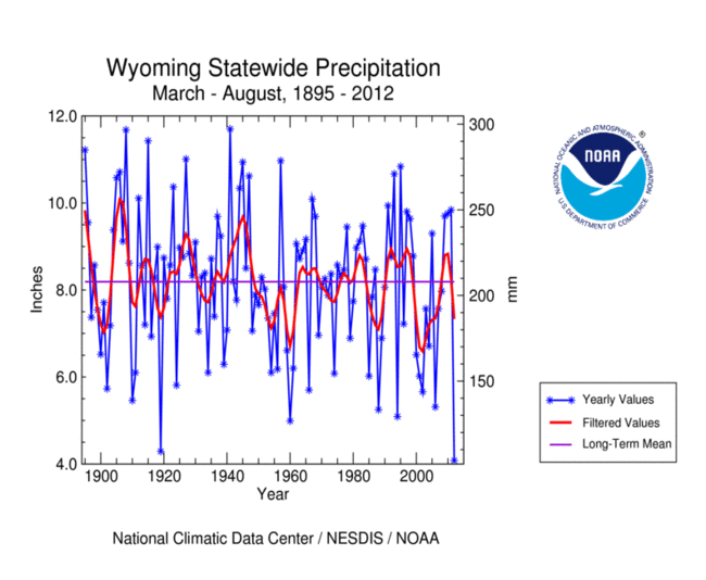
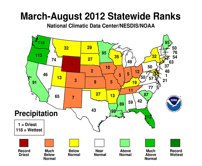
The spatial pattern at the six month time scale is similar to the spatial pattern of summer (June-August). Delaware and Wyoming had the driest March-August on record, eight other states ranked in the top ten category, and an additional 13 states were in the driest third of the historical record. A similar pattern was evident for the year-to-date. At the 12-month time scale, dryness dominates from the West to the Midwest. September 2011-August 2012 ranked in the top ten driest category for six states, with 13 other states ranking in the driest third of the historical record. Delaware, Nebraska, and Wyoming each ranked second driest for September 2011-August 2012.
 |
 |
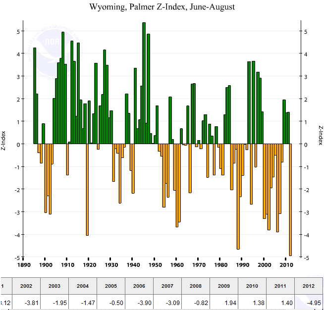
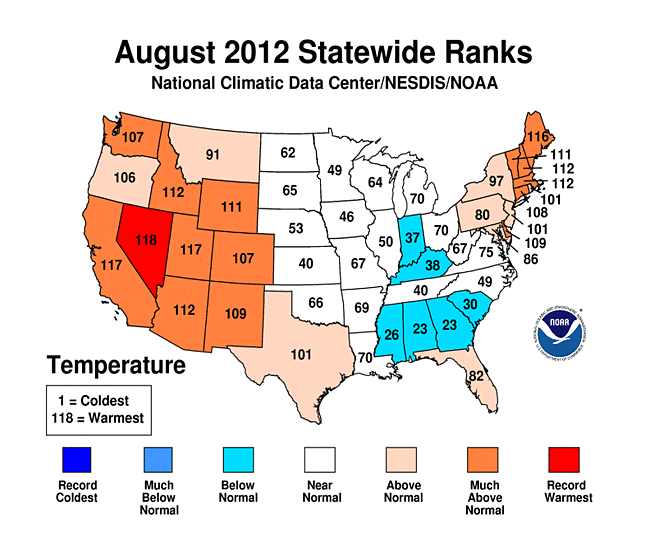
August 2012 had near to below-normal temperatures for the Midwest to Southeast, interrupting a warm streak for that part of the country, but record to near-record heat occurred for states in the West. For most of the last twelve months, the extreme dryness has been accompanied by extreme heat for the drought areas across the country. For example, both Colorado and Wyoming had the hottest summer on record and Nebraska and Wyoming had the driest summer on record. As noted earlier, excessive heat increases evapotranspiration and exacerbates drought. The combination of driest and third warmest summer gave Nebraska the second most severe June-August averaged Palmer Z Index in the 1895-2012 record, behind 1936. The driest and warmest summer gave Wyoming the most severe June-August averaged Palmer Z Index on record. The dryness and excessive heat have been so persistent for the state that Wyoming has had the most severe averaged Palmer Z Index for the last six months (March-August) and the third most severe averaged Palmer Z Index for the last twelve months (September-August) (behind 1934 and 2002).
 |
 |
Corn and Soybean Belt
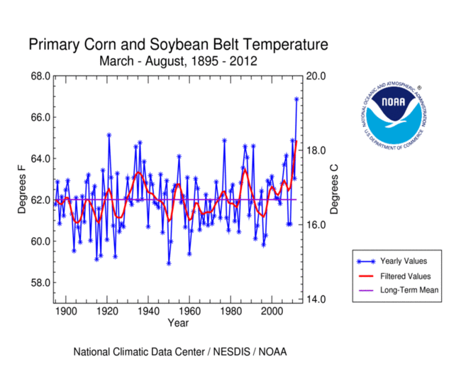
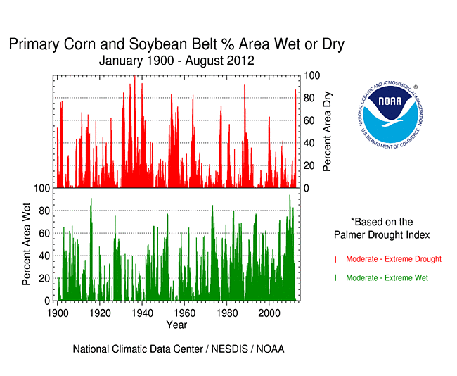
The Primary Corn and Soybean agricultural belt has been especially hard hit by drought this year. Each month of the growing season has had significant short-term dryness (as measured by the Palmer Z Index). This region, collectively, has experienced the warmest and seventh driest March-August in 2012, resulting in the fourth most severe Palmer Z Index (behind 1936, 1934, and 1988). The extreme severity of the dryness and evapotranspiration demand over the growing season resulted in a rapid increase in the percent area of this agricultural belt experiencing moderate to extreme drought (as defined by the Palmer Drought Index) and moderate to exceptional drought (for the Midwest and High Plains as defined by the USDM). The August rains in the eastern part of this region were beneficial and helped reduce the intensity of the drought there, but they did little to shrink the overall drought area for the entire region. By the end of August 2012, about 83 percent of the Primary Corn and Soybean Belt was experiencing moderate to extreme drought (based on the Palmer Drought Index), surpassing all previous droughts except those in 1988 and the 1930s.
Western U.S.
Showers and thunderstorms from the summer monsoon brought above-normal rainfall to parts of the Southwest again this month, but most of the West was dry, especially from the Pacific Northwest to Northern Rockies where Washington and Wyoming had the driest August on record. The combination of dryness and excessive heat resulted in a large area of extreme short-term drought. The rain that fell in the extreme Southwest did little to change the overall percent area in drought. Drier-than-normal weather has dominated much of the West for the water year to date (October-present), as reflected in low elevation as well as high elevation (SNOTEL) precipitation, especially for the southern half of the West. Reservoir storage was below average, statewide, in most of the western states. Hot, dry, windy weather contributed to many wildfires across the West. According to the USDM, 74 percent of the West was experiencing moderate to exceptional drought at the end of August, a 6 percent increase compared to July. The Palmer Drought Index percent area statistic was about 55 percent, about the same as last month.
 |
 |
Historical Analogs
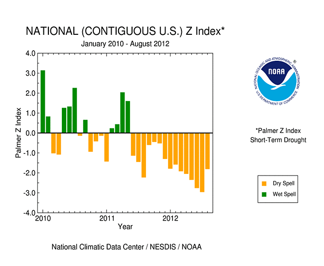
The persistent warmth and dryness of the last couple years continued on a national scale during August 2012. Water demand has consistently outstripped water supply on a national scale for the last 15 consecutive months, as indicated by the persistently negative nationally-integrated Palmer Z Index. This is largely behind the rapid expansion of drought this year (USDM, Palmer Drought Index). While dropping slightly from the July peak, the percent area in moderate drought or worse remained quite high, well above the 50 percent level. The last time drought was as extensive as summer 2012 was in December 1956 when about 58 percent was in moderate to extreme drought.
Even though every drought is different, historical analogs to the current drought can be determined by comparing the spatial pattern and intensity of various climate indicators using statistical tools such as the correlation coefficient and mean absolute difference. The table below lists those years that have the closest relative spatial pattern to that for August, summer (June-August), and year-to-date (January-August) 2012 for four climate indicators (precipitation, temperature, PHDI, and Palmer Z Index). For August, many analogs can be found from many different years. There is no consistent pattern between the indicators except for PHDI, which most closely matches the 1950s. When each month from January-August 2012 is compared individually to its corresponding month from previous years, the best matches for precipitation, PHDI, and Palmer Z Index come from drought years, with 1988 standing out. When average year-to-date 2012 conditions are compared to average year-to-date of past years, 1955 stands out for PHDI and the Palmer Z Index. For the summer months individually, the 1930s and 1950s are prominent for the drought indicators (PHDI and Palmer Z Index). For average summer conditions, 1988 stands out for precipitation and the Palmer Z Index, the 1950s for PHDI, and 2002 and 2006 for temperature.
| Month or Season | Precipitation and Temperature | PHDI | Palmer Z Index | |
|---|---|---|---|---|
| August 2012 (all months) | July 1920 | July 1979 | May 1954 | September 1943 |
| August 2012 (only August's) | August 1919 | August 1985 | August 1955 | August 1970 |
| January-August 2012 (each month individually) | 1934, 1988 | 1921, 1946 | 1955, 2006 | 1988, 2002 |
| June-August 2012 (each month individually) | 1985, 1913 | 1901, 2002 | 1955, 1954 | 1934, 1931 |
| Year-to-date (Jan-Aug) 2012 | 1966, 1926 | 2006, 1921 | 1955, 2000 | 1988, 1955 |
| Summer (Jun-Aug) 2012 | 1988, 1946 | 2002, 2006 | 1955, 1954 | 1934, 1988 |
A more detailed drought discussion, provided by the NOAA Regional Climate Centers and others, can be found below.
West — Upper Colorado River Basin — Pacific Islands
As noted by the Southeast Regional Climate Center, August mean temperatures were near normal to below normal and precipitation was generally above normal across the Southeast. Monthly temperatures were variable across Puerto Rico and below normal over the U.S. Virgin Islands. Heavy rainfall from Isaac fell on parts of the Southeast, including Puerto Rico where 4 to 8 inches fell with locally heavier amounts across the interior mountains. For the second straight month, drought conditions improved or stabilized across the Southeast. By the end of August, over 60 percent of the region was drought-free, up from 40 percent at the end of July. Most notably, drought conditions were eliminated in Florida (the first time the state has been drought-free in over two years), and across a large section of Alabama. Additionally, improvements of one to two drought categories in the USDM were observed across South Carolina by the end of the month. There was a slight contraction of drought conditions across central Georgia; however, over one-third of the state remained in extreme (D3) or exceptional (D4) drought. By the end of the month, the harvesting of row crops was nearly complete (some delays were reported in areas that were particularly wet, especially along the Florida Panhandle) and most crops were reported to be in generally good condition across much of the region. The beneficial rain also helped livestock and pasture conditions, though some farmers were beginning to spray for disease and insects. Tobacco and cotton were also being sprayed in areas that were particularly wet.
As explained by the Southern Regional Climate Center, August precipitation varied dramatically over the Southern region, mostly in part to Hurricane Isaac which drenched much of Louisiana, Mississippi, and southern Arkansas. Elsewhere, such as Texas and Oklahoma, conditions were quite dry. The driest part of the region was observed in southern Texas, where a majority of the stations received only between 0 to 50 percent of normal precipitation. Temperatures varied spatially across the region, with cooler-than-normal values in the east and warmer-than-normal values in the west. Drought conditions remain relatively unchanged, despite heavy rainfall totals in the southeastern portion of the region. This is in part due to the fact that much of the drought in this region is situated in areas outside of the reach of Hurricane Isaac. Conditions deteriorated though most of Oklahoma, with almost the entire state being in extreme or exceptional drought. Elsewhere, the majority of Texas was still experiencing moderate to severe drought conditions. This was also the case in western Tennessee, where conditions were generally drier than normal for the month. In the case of Arkansas, much of the northern portions of the state were in exceptional to extreme drought conditions.
As summarized by the Midwest Regional Climate Center, August temperatures averaged to near normal across the Midwest. The first and last weeks of the month were above normal but the middle two weeks were below normal. Daily records followed the same pattern with mostly record highs on the first and last eight days of the month while mostly record lows were recorded from the 9th to the 23rd. The two cooler weeks in the middle of the month were a welcome break in a warm year. Precipitation totals were above normal in south central Missouri and from western Kentucky, into southeast Illinois, across northern and central Indiana, and into northwest Ohio and southeast Michigan. The rest of the region was below normal with northern and central Missouri hardest hit at less than 25 percent of normal for August. Summer rainfall was below normal for most of the region. Summer totals were less than half of normal in parts of Missouri, Iowa, Illinois, southern Indiana, southwest Wisconsin, and southwest Minnesota. A few locations in the upper Midwest and Kentucky were slightly above normal for the summer. Year-to-date precipitation totals were less than 75 percent of normal for most of Missouri, Iowa, Illinois, Indiana, and western Kentucky. The upper Midwest had a mix of above and below normal totals for the year-to-date. The rainfall deficits for those areas ranged from 6 to 14 inches (150 to 350 mm).
Drought conditions in the Midwest saw both improvement and degradation during August. In southern Michigan, northern Indiana, and northwest Ohio, rains eased the drought but in Missouri and western Iowa conditions got worse through the month. While the percentage of the region in drought dropped from 71 percent to 65 percent in August, the areas in extreme (32 to 33 percent) and exceptional (5 to 7 percent) drought increased. The biggest improvements were in Indiana, Michigan, and Ohio while Iowa and Missouri had the largest degradations. August rains were too late for improvements in the corn crop conditions but there were some improvements in soybean conditions in locations that received above normal rains.
As noted by the Northeast Regional Climate Center, August temperatures averaged 1.7 degrees F (0.9 degrees C) above normal in the Northeast region and it was the twelfth warmest summer in the region since recordkeeping began in 1895. August precipitation averaged 3.90 inches (99.1 mm) regionwide, which was 100 percent of normal. For the most part, areas closest to the coast saw above normal rainfall, while inland regions were drier than normal. Maine (127 percent), Maryland (123 percent), Massachusetts (124 percent), New Hampshire (122 percent) and New Jersey (134 percent) were the states with positive precipitation departures. Departures in the remaining states ranged from 70 percent of normal in Vermont to 100 percent in Delaware. This was the first month since September 2011 that Delaware's precipitation was not below normal. Summer (June through August) precipitation totals averaged below normal in the Northeast (95 percent) and in eight of the twelve states. The four wetter-than-normal states were New Hampshire (102 percent), Rhode Island (106 percent), New Jersey (108 percent), and Maine (126 percent). It was the eleventh wettest summer since 1895 in Maine. Departures in the drier-than-normal states ranged from 98 percent in Massachusetts to 77 percent in West Virginia, where it was the 22nd driest summer in 118 years. The USDM issued August 28, 2012 indicated that conditions improved slightly in Delaware, but the southern two-thirds of the state were still in D1 (moderate) or D2 (severe) drought. In addition, slight improvements were seen in Maryland where most areas of D2 drought surrounding Chesapeake Bay on July 31 improved to D1 on August 28. Conditions in Massachusetts also improved — the region of D1 drought in the western two thirds at end of July shrank to just the southwestern portions of the state. A new area of abnormally dry conditions popped up in northern Vermont.
As explained by the High Plains Regional Climate Center, for the first time since February of this year, there were widespread below-normal monthly temperatures in the High Plains region. Much of North Dakota, South Dakota, Kansas, and southern Nebraska had average temperatures which were up to 3.0 degrees F (1.7 degrees C) below normal. Meanwhile, areas of Colorado, Wyoming, southern South Dakota, and western and central Nebraska had temperatures which were above normal. August was yet another dry month for the majority of the region. A large expanse — including Wyoming, eastern Colorado, the eastern and western sides of Kansas, most of Nebraska, central and southern South Dakota, and pockets of North Dakota — had precipitation totals which were at the most 50 percent of normal. There were even areas of Wyoming, northeast Colorado, and the panhandle of Nebraska which received less than 5 percent of normal precipitation. Because of the lack of precipitation, new records were set again this month. For instance, Scottsbluff, Nebraska received no measurable precipitation and set a new record for driest August. The old record of 0.04 inch (1 mm) was set in 2001 (period of record 1893-2012). On average, Scottsbluff receives 1.30 inches (33 mm) of precipitation in August. Another location which had its driest August on record was Colorado Springs, Colorado which received only 0.12 inch (3 mm) of precipitation. This beat out the old record of 0.15 inch (4 mm) set in 1962 (period of record 1894-2012). The only areas of the region which received much needed rainfall were pockets of central North Dakota, central and northeastern Kansas, far southeastern Nebraska, and a few pockets of western Colorado. These areas had precipitation totals ranging from 110 percent of normal to 300 percent of normal.
The heavy rainfall improved drought conditions; however, at this point many of the crops will not benefit from the precipitation. According to the USDM, drought conditions worsened yet again this month across the High Plains region. By the end of August, about 88 percent of the region was under moderate (D1) to exceptional (D4) drought, with nearly 15 percent of the region in the D4 designation. In contrast, at the end of last month, only 4 percent of the region was in D4. Over the past month, the D4 areas that expanded include an area in central Nebraska that grew westward across the state and even into northeastern Colorado, an area in western Kansas that expanded all the way across the middle of the state to the eastern border, and an area in eastern Colorado that grew to include most of the southeastern corner of the state. By the end of the month over half the state of Kansas was in D4 drought. Extreme drought conditions (D3) also expanded in Colorado, Nebraska, South Dakota, and Wyoming. In addition, there was only a little over one percent of the region that did not have any sort of drought or abnormally dry conditions (D0). August was a busy month for producers as drought-damaged crops had to be chopped for silage or baled for hay in Nebraska, Kansas, and the Dakotas. The lack of feed and water caused the culling of herds to continue in Nebraska and Kansas. According to the USDA, by the end of the month 85 percent of all corn, 82 percent of all soybeans, 63 percent of all hay acreage, and 72 percent of all cattle were within an area experiencing drought conditions in the United States. This was a slight improvement from last month.
Summer (June, July, and August) 2012 went down as one of the hottest on record for many locations in the region. It was an overall dry summer for the region and most locations ranked in the top 20 driest summers. Some locations set new precipitation records as well. Grand Island, Nebraska had its driest summer on record with only 2.37 inches (60 mm) of precipitation. This was 8.45 inches (215 mm) below normal and only 22 percent of normal precipitation. The old record of 2.87 inches (73 mm) was set back in the summer of 1940 (period of record 1895-2012). The impacts from the hot and dry summer have been numerous and many more will be realized as the summer is assessed. Just some of the impacts include widespread drought, crop damage and failure, low river levels, and fish kills.
As summarized by the Western Regional Climate Center, an active monsoon doused the southern Great Basin this month, while drier conditions dominated the Northwest. Hot, dry, and windy conditions primed the region for development of numerous large and destructive wildfires. In conjunction with the fires, poor air quality prevailed in many areas, notably Idaho, Montana, and the northwestern Great Basin. Average August temperatures ranged from 2-6 F (1-3 C) above normal over most of the West, with some locations recording their hottest August on record. Only the coastal regions of northern California and southern Oregon and a few other isolated locations averaged cooler than normal for the month. Triple digit temperatures and record high minimum temperatures dominated much of the Southwest this August.
A persistent upper-level ridge and strong surface heating over the Great Basin and desert Southwest facilitated moisture transport into the area, supporting monsoon activity. The southern Great Basin saw most of the action, with numerous accounts of flash flooding, and several instances of record daily precipitation. Many locations in the Southwest that receive a large portion of their annual precipitation during the summer monsoon (Las Vegas, Nevada and Phoenix, Yuma, and Tucson, Arizona) recorded above or near average August precipitation totals and are on track to meet the monsoon season (June-Sept) average at their respective locations. In contrast, New Mexico was dry in August, and statewide has experienced its driest 18 consecutive month period on record. By mid-August, 89 percent of the pasture and rangelands there were rated as poor, one of the highest percentages in the nation. Farther north, Reno Nevada experienced the third driest water year to date in its 75-year airport record. The Pacific Northwest, which typically experiences low rainfall totals in August, was exceptionally dry this month. August 31st marked 42 days without measurable precipitation in Portland, Oregon, the 14th longest streak of this type on record. Billings, Montana experienced its driest first 8 months of the year since records began in 1934, receiving only 5.08 in (129 mm) in that time, 52 percent of average and below the previous minimum of 5.82 in (147.8 mm) in 1946.
Upper Colorado River Basin: As reported by the Colorado Climate Center, the September 4th NIDIS (National Integrated Drought Information System) assessment for the Upper Colorado River Basin (UCRB) indicated that, for the month of August, precipitation was concentrated around the central mountains of Colorado and in southeast Utah in the UCRB. The central Colorado mountains received near normal precipitation for the month, while southeast Utah received between 90 percent to almost 200 percent of average precipitation. The northern part of the UCRB was drier, with most areas receiving less than 90 percent of average precipitation. East of the basin, the Front Range and eastern Colorado were drier, receiving between 30 percent and 70 percent of average with many areas in northeast Colorado seeing zero percent of their average monthly precipitation. Water-year-to-date (WYTD) SNOTEL precipitation percentiles were low for the Yampa and Gunnison basins in Colorado, and the Wasatch range in Utah, with many sites reporting in the lowest 10th percentile or below. The northern mountains of Colorado were also dry, with most sites reporting precipitation percentiles in the teens and single digits. SNOTEL percentiles in the Upper Green basin in Wyoming were around the 20th to 30th percentiles, and percentiles in the San Juan basin were in the teens and 20s. For the month of August, temperatures were above average for all the of UCRB and eastern Colorado, with anomalies ranging from 1 to 5 degrees above normal.
Satellite vegetation conditions showed the driest vegetation over northeast Utah, with dry conditions extending into western Colorado and southern Wyoming. Very dry vegetation was also showing up over northeast Colorado and along the Arkansas valley in southeast Colorado. Reference ET (evapotranspiration) rates were still higher than average across the basin though not above the record. East of the basin, most of the reference ET sites were recording record high years, with daily ET rates between .20 to .30 inches.
About 47 percent of the USGS streamgages in the UCRB recorded normal (25th - 75th percentile) or above normal 7-day average streamflows. About 5 percent of the gages in the UCRB were recording above normal flows, while about 26 percent percent of the gages in the basin were recording much below normal or low (i.e. lowest on record) streamflows. The Yampa-White Basin was still recording in the moderate hydrologic drought category (below the 10th percentile), and the Upper San Juan River, the lower Green River and the Colorado Headwaters were mainly in the below normal category for streamflow. In August, all of the major reservoirs in the UCRB saw storage volume decreases, which is expected during the demand season. Most of the reservoirs experienced larger decreases than what is normal for this time of year with McPhee seeing a 12.3 percent decrease and Green Mountain seeing a 10.4 percent decrease. Flaming Gorge saw the smallest decrease, with storage volumes falling only 1 percent, which is average for that reservoir this time of year. All of the reservoirs were below their September averages, with most between 70 percent and 90 percent of average. Green Mountain was at 64 percent of average, Blue Mesa at 60 percent of average, and Lake Powell at 71 percent of average.
Pacific Islands: According to reports from National Weather Service offices, the Pacific ENSO Applications Climate Center (PEAC), and partners, conditions varied across the Pacific Islands.
As noted by the National Weather Service office in Honolulu, persistent and stable trade wind conditions kept most of the leeward areas of Hawaii very dry throughout August. The sustained dryness on the island of Lanai resulted in a downgrade from severe drought, or the D2 category on the USDM map, to extreme drought, or the D3 category, over the leeward slopes of the island. Severe drought on Kauai has also spread westward along the lower leeward elevations and now covers the island from Kealia to Koloa, then westward to Waimea. Elsewhere in the state, the area of extreme drought remained unchanged over leeward areas of Molokai, Maui and the Big Island. In Maui County these areas included western Molokai and southwest Maui from Kihei to Makena. Big Island extreme drought covers most of the south Kohala district, the Pohakuloa region of the Hamakua district and the north-facing slopes of Hualalai in the north Kona district. Severe drought continued over the lower elevations of southwest Kau and portions of the Humuula Saddle on the Big Island, the lower leeward slopes of the west Maui mountains and the leeward slopes of Haleakala from Kula to Kaupo. The area of moderate drought, or D1 conditions, remained unchanged in leeward Oahu.
Some drought impacts impacts in Hawaii include the following:
KAUAI.
THE AREA OF DROUGHT IMPACTS HAS BEEN SPREADING WESTWARD.   RECENT
REPORTS INDICATED POOR PASTURE CONDITIONS IN THE AREA FROM KALAHEO
TO HANAPEPE.  OTHER AREAS WITH POOR PASTURE CONDITIONS INCLUDE THE
REGION FROM KOLOA TO MAHAULEPU...AND FROM KEALIA TO KALEPA.

OAHU.
NO SIGNIFICANT CHANGES SINCE THE AUGUST 9 UPDATE.  LEEWARD PASTURES
REMAIN IN POOR CONDITION AND THE GENERAL LANDSCAPE IS VISIBLY VERY
DRY.  REPORTS FROM EARLIER IN THE SUMMER INDICATED THAT SOME
RANCHERS DESTOCKED PASTURES IN THE WAIALUA...MAKAKILO AND PALEHUA
AREAS OF THE ISLAND.

THE WATER SUPPLY IN THE WAIMANALO RESERVOIR REMAINS ABOVE
PRE-DROUGHT LEVELS.  A VOLUNTARY 10 PERCENT REDUCTION IN WATER USE
REMAINS IN PLACE AS A PRECAUTION FOR THE DRY SEASON.

MOLOKAI.
NO SIGNIFICANT CHANGES SINCE THE AUGUST 9 UPDATE.   PASTURES AND
GENERAL VEGETATION CONDITIONS REMAIN VERY POOR WEST OF KAUNAKAKAI.
AN EARLIER REPORT INDICATED THAT THE DRY CONDITIONS HAVE RESULTED IN
AN INCREASE IN AXIS DEER ENCROACHMENTS AND CROP DAMAGE AS THEY SEEK
FOOD AND WATER.

THE WATER LEVEL IN THE KUALAPUU RESERVOIR REMAINS VERY LOW.
THUS...THE STATE OF HAWAII DEPARTMENT OF AGRICULTURE HAS CONTINUED A
MANDATORY 30 PERCENT REDUCTION IN IRRIGATION WATER CONSUMPTION.

LANAI.
A REPORT FROM THE ISLAND INDICATED THAT EVEN DROUGHT-RESISTANT
PLANTS AND TREES SUCH AS KIAWE WERE STRUGGLING UNDER THE DRY
CONDITIONS.  MOUFLON SHEEP...AXIS DEER AND GAME BIRD POPULATIONS
HAVE BEEN REDUCED.  THE GREATEST IMPACTS HAVE BEEN ALONG THE LOWER
AND MIDDLE ELEVATIONS ON THE LEEWARD SIDE OF THE ISLAND AND ARE AS
BAD AS BACK IN 2010.

MAUI.
UPCOUNTRY AGRICULTURE CONTINUES TO BE SIGNIFICANTLY IMPACTED BY THE
ONGOING DROUGHT. MEDIA REPORTS INDICATED THAT RANCHERS HAVE HAD TO
INCREASE IRRIGATION...SUPPLEMENT FEED AND REDUCE HERD SIZES.
ENCROACHING AXIS DEER HAVE ALSO DECREASED FORAGE FOR LIVESTOCK.
BRUSH FIRE RISK...ESPECIALLY ALONG THE SOUTHWEST SLOPES OF
HALEAKALA...IS EXTREMELY HIGH.  THE MAUI COUNTY DEPARTMENT OF WATER
SUPPLY HAS CONTINUED THE ONGOING CALL FOR A 5 PERCENT REDUCTION IN
WATER USE FOR UPCOUNTRY RESIDENTS.  THE REQUEST FOR A 10 PERCENT
REDUCTION IN WATER USE BY CENTRAL AND SOUTH MAUI ALSO REMAINS IN
EFFECT.

BIG ISLAND.
LEEWARD KOHALA COASTAL PASTURES HAVE BEEN WITHOUT FORAGE FOR SEVERAL
MONTHS.  RANCHERS NEAR SOUTH POINT HAVE ALSO REPORTED VERY POOR
FORAGE CONDITIONS UP TO ABOUT THE 500 FT ELEVATION LEVEL.  REQUESTS
FOR FEED ASSISTANCE HAVE BEEN COMING IN FROM THE PUUKAPU...SOUTH
KOHALA...NAALEHU AND PAHALA AREAS.  A PROTEA FARMER IN THE OCEAN
VIEW ESTATES AREA REPORTED HAVING TO HAUL 20000 GALLONS OF WATER FOR
OPERATIONS.

On other Pacific Islands (maps — Micronesia, Marshall Islands, basinwide), August was drier than normal for Lukonor, Majuro, and Pago Pago, but near to above normal for the rest of the stations. Total rainfall for the last 12 months (September 2011-August 2012) was near to above normal for all stations.
| Station Name | Sep 2011 | Oct 2011 | Nov 2011 | Dec 2011 | Jan 2012 | Feb 2012 | Mar 2012 | Apr 2012 | May 2012 | Jun 2012 | Jul 2012 | Aug 2012 | Sep- Aug |
|---|---|---|---|---|---|---|---|---|---|---|---|---|---|
| Chuuk | 118% | 97% | 136% | 125% | 57% | 181% | 107% | 40% | 173% | 131% | 141% | 169% | 117% |
| Guam NAS | 129% | 135% | 83% | 103% | 162% | 94% | 215% | 121% | 224% | 107% | 66% | 179% | 108% |
| Kapingamarangi | 107% | 57% | 81% | 124% | 109% | 71% | 121% | 102% | 143% | 179% | 146% | 192% | 108% |
| Koror | 266% | 12% | 62% | 97% | 36% | 126% | 121% | 120% | 122% | 95% | 88% | 102% | 94% |
| Kosrae | 104% | 154% | 95% | 174% | 65% | 185% | 60% | 84% | 86% | 99% | 124% | 144% | 94% |
| Kwajalein | 111% | 125% | 130% | 84% | 134% | 114% | 84% | 68% | 161% | 117% | 120% | 95% | 109% |
| Lukonor | 156% | 56% | 154% | 251% | 86% | 124% | 135% | 76% | 106% | 125% | 82% | 73% | 102% |
| Majuro | 115% | 115% | 119% | 91% | 107% | 65% | 194% | 97% | 59% | 81% | 68% | 87% | 97% |
| Pago Pago | 29% | 137% | 157% | 75% | 61% | 98% | 131% | 90% | 126% | 115% | 105% | 59% | 87% |
| Pohnpei | 115% | 77% | 123% | 110% | 82% | 138% | 98% | 45% | 115% | 100% | 92% | 96% | 95% |
| Saipan | 68% | 140% | 57% | 110% | 77% | 183% | 35% | 33% | 166% | 118% | 77% | 135% | 100% |
| Yap | 156% | 101% | 112% | 116% | 33% | 117% | 185% | 89% | 142% | 99% | 84% | 128% | 108% |
| Station Name | Sep 2011 | Oct 2011 | Nov 2011 | Dec 2011 | Jan 2012 | Feb 2012 | Mar 2012 | Apr 2012 | May 2012 | Jun 2012 | Jul 2012 | Aug 2012 | Sep- Aug |
|---|---|---|---|---|---|---|---|---|---|---|---|---|---|
| Chuuk | 13.76" | 11.14" | 14.44" | 14.01" | 5.74" | 13.13" | 8.87" | 5.02" | 19.56" | 15.27" | 16.92" | 21.78" | 159.64" |
| Guam NAS | 16.37" | 15.45" | 6.14" | 5.24" | 6.50" | 2.85" | 4.45" | 3.05" | 7.63" | 6.63" | 6.74" | 26.42" | 107.47" |
| Kapingamarangi | 10.64" | 4.63" | 7.54" | 12.19" | 9.94" | 6.61" | 13.82" | 13.91" | 17.24" | 24.68" | 20.65" | 15.57" | 157.42" |
| Koror | 31.35" | 1.39" | 7.04" | 10.79" | 3.65" | 10.81" | 9.03" | 8.79" | 14.49" | 16.54" | 16.36" | 13.72" | 143.96" |
| Kosrae | 14.82" | 16.83" | 13.07" | 28.11" | 10.89" | 23.93" | 9.59" | 14.70" | 15.35" | 14.56" | 18.55" | 20.46" | 200.86" |
| Kwajalein | 11.95" | 14.00" | 14.68" | 5.59" | 4.22" | 3.01" | 1.97" | 3.58" | 10.82" | 8.08" | 11.83" | 9.23" | 98.96" |
| Lukonor | 15.79" | 6.38" | 14.02" | 28.34" | 7.22" | 11.06" | 12.51" | 8.60" | 12.35" | 14.53" | 13.08" | 10.26" | 154.14" |
| Majuro | 12.87" | 14.65" | 15.97" | 10.37" | 8.27" | 4.46" | 12.75" | 9.14" | 5.96" | 8.89" | 7.54" | 10.15" | 121.02" |
| Pago Pago | 1.92" | 12.67" | 15.91" | 9.69" | 8.14" | 11.76" | 14.00" | 8.41" | 12.15" | 6.13" | 5.84" | 3.19" | 109.81" |
| Pohnpei | 14.44" | 11.74" | 18.21" | 17.61" | 10.75" | 13.17" | 12.92" | 8.31" | 22.98" | 14.86" | 14.21" | 13.62" | 172.82" |
| Saipan | 6.91" | 14.90" | 3.22" | 4.23" | 1.96" | 4.75" | 0.66" | 0.88" | 3.96" | 4.26" | 6.86" | 17.73" | 70.32" |
| Yap | 21.03" | 12.32" | 9.92" | 9.91" | 2.11" | 6.09" | 8.43" | 5.00" | 11.14" | 11.95" | 12.74" | 18.92" | 129.56" |
| Station Name | Sep 2011 | Oct 2011 | Nov 2011 | Dec 2011 | Jan 2012 | Feb 2012 | Mar 2012 | Apr 2012 | May 2012 | Jun 2012 | Jul 2012 | Aug 2012 | Sep- Aug |
|---|---|---|---|---|---|---|---|---|---|---|---|---|---|
| Chuuk | 11.71" | 11.51" | 10.61" | 11.25" | 10.10" | 7.25" | 8.32" | 12.47" | 11.30" | 11.66" | 11.98" | 12.86" | 136.77" |
| Guam NAS | 12.66" | 11.44" | 7.38" | 5.11" | 4.01" | 3.03" | 2.07" | 2.53" | 3.40" | 6.18" | 10.14" | 14.74" | 99.09" |
| Kapingamarangi | 9.93" | 8.19" | 9.27" | 9.84" | 9.15" | 9.27" | 11.43" | 13.64" | 12.08" | 13.78" | 14.15" | 8.13" | 145.85" |
| Koror | 11.77" | 11.84" | 11.39" | 11.16" | 10.18" | 8.56" | 7.44" | 7.32" | 11.83" | 17.48" | 18.53" | 13.50" | 152.90" |
| Kosrae | 14.22" | 10.94" | 13.83" | 16.11" | 16.67" | 12.93" | 16.06" | 17.51" | 17.75" | 14.64" | 14.91" | 14.22" | 213.87" |
| Kwajalein | 10.74" | 11.18" | 11.28" | 6.66" | 3.16" | 2.64" | 2.35" | 5.26" | 6.72" | 6.93" | 9.87" | 9.74" | 90.41" |
| Lukonor | 10.15" | 11.32" | 9.08" | 11.27" | 8.41" | 8.93" | 9.26" | 11.31" | 11.69" | 11.65" | 15.93" | 14.04" | 151.36" |
| Majuro | 11.17" | 12.73" | 13.44" | 11.39" | 7.74" | 6.88" | 6.58" | 9.42" | 10.11" | 11.01" | 11.17" | 11.69" | 125.25" |
| Pago Pago | 6.53" | 9.26" | 10.14" | 12.84" | 13.34" | 12.00" | 10.68" | 9.39" | 9.66" | 5.33" | 5.55" | 5.38" | 125.57" |
| Pohnpei | 12.55" | 15.27" | 14.83" | 16.08" | 13.18" | 9.55" | 13.17" | 18.41" | 19.96" | 14.81" | 15.43" | 14.26" | 182.36" |
| Saipan | 10.09" | 10.62" | 5.61" | 3.85" | 2.53" | 2.59" | 1.89" | 2.63" | 2.38" | 3.62" | 8.91" | 13.13" | 70.25" |
| Yap | 13.50" | 12.18" | 8.83" | 8.51" | 6.39" | 5.19" | 4.56" | 5.63" | 7.85" | 12.04" | 15.08" | 14.82" | 120.31" |

[top]
State/Regional/National Moisture Status
A detailed review of drought and moisture conditions is available for all contiguous U.S. states, the nine standard regions, and the nation (contiguous U.S.):
| northeast u. s. | east north central u. s. | central u. s. |
| southeast u. s. | west north central u. s. | south u. s. |
| southwest u. s. | northwest u. s. | west u. s. |
| Contiguous United States |
[top]
Drought Indicators
- Palmer Drought Indices
- Standardized Precipitation Index
- long-term (36 to 60 month) percent of normal precipitation maps
- airport station percent of normal precipitation maps
- statewide precipitation rank maps
- Cooperative station percent of normal precipitation maps
- percent of average maps for the SNOTEL stations in the western mountains provided by the Western Regional Climate Center
- hydrologic year precipitation
- snow water equivalent of snowpack
- satellite-based observations of vegetative health
- National Weather Service model calculations of soil moisture, runoff, and evaporation
- National Weather Service model calculations of soil moisture using the Leaky Bucket Model
- Midwest Regional Climate Center model calculations of soil moisture
- topsoil moisture conditions observed by the USDA and mapped by the Climate Prediction Center
- pasture and range land conditions observed by the USDA and mapped by the Climate Prediction Center
- streamflow maps maintained by the USGS
[top]
Contacts & Questions
 NOAA's National Centers for Environmental Information