Note: This Synoptic Discussion describes recent weather events and climate anomalies in relation to the phenomena that cause the weather. These phenomena include the jet stream, fronts and low pressure systems that bring precipitation, high pressure systems that bring dry weather, and the mechanisms which control these features — such as El Niño, La Niña, and other oceanic and atmospheric drivers (PNA, NAO, AO, and others). The report may contain more technical language than other components of the State of the Climate series.
Synoptic Discussion
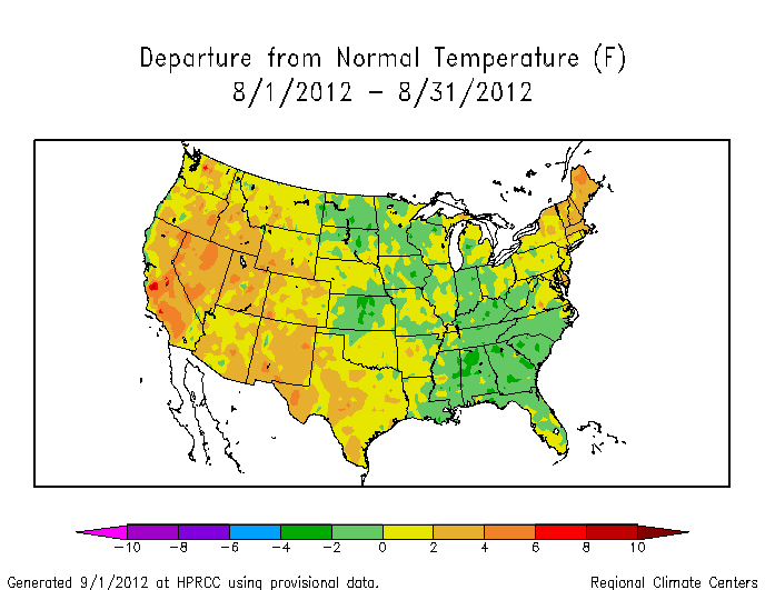
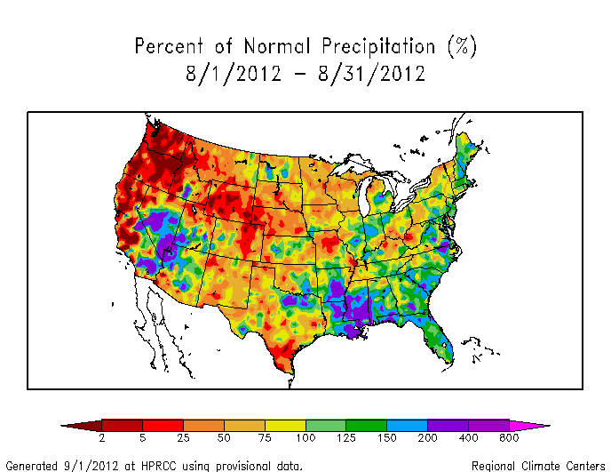
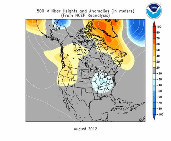
The  weather pattern over North America during August 2012 consisted of a battle between subtropical high pressure (High, or upper-level ridge) to the south and the polar jet stream and associated storm track to the north. The jet stream frequently pushed upper-level troughs and cool fronts into the High over the eastern U.S., while the remnants of Hurricane Isaac moved up the Mississippi Valley at the end of the month and became absorbed into a cool front along the Ohio Valley at the beginning of September. When averaged over the month of August, this pattern resulted in warmer-than-average temperatures beneath an upper-level ridge over the western U.S. and cooler-than-average temperatures beneath an upper-level trough over the Southeast. Although summer monsoon showers brought above-normal precipitation to parts of the Southwest, descending air ("subsidence") associated with the High dominated the West and Great Plains, giving Nebraska, Washington, and Wyoming the driest August in the 1895-2012 record. Numerous wildfires broke out in the hot, dry, windy weather across the West and Plains, giving August 2012 a record high acreage burned. This weather pattern inhibited the formation of tornadoes, with the preliminary national count of 52 tornadoes being below the long-term average. Of the tornadoes that did occur, many were associated with Isaac.
The movement of fronts in the Midwest and East, and monsoon showers in the West, can be seen in the weekly above-normal precipitation anomaly patterns (weeks 1, 2, 3, 4, 5). The persistent dryness in the Northwest and much of the Plains is also evident. The weather pattern during August shielded the U.S. mainland from most tropical activity. Of the six Atlantic Basin tropical storms and hurricanes that formed during the month, only Isaac made landfall. And while significant flooding occurred with Isaac, especially along the Gulf coast (Louisiana and Mississippi had the second wettest August on record), its rains brought relief to some parts of the Midwest drought area. Beneficial rains contracted the drought area in the Southeast and rainfall from Isaac improved drought conditions in the Lower Mississippi and Ohio valleys. But drought expanded in the West and intensified in the Great Plains beneath the hot, dry ridge. According to the end-of-August (August 28) U.S. Drought Monitor, 62.9% of the contiguous U.S. (52.6% of the U.S. including Alaska, Hawaii, and Puerto Rico) was affected by moderate to exceptional drought overall. These values are about the same as the end of July. However, the areas affected by the worst drought categories (extreme and exceptional drought) increased, indicating that the drought has gotten more intense. According to the Palmer Drought Index, which goes back to the beginning of the 20th century, 55.1% of the contiguous U.S. was in moderate to extreme drought, a decrease of about 3 percent compared to last month. The percent area in severe to extreme drought increased to 39.0%, confirming that the drought has intensified. The 2012 Palmer Drought Index percent area values have been exceeded only by the droughts of the 1930s and 1950s.
The movement of the cool fronts can also be seen in the weekly temperature anomaly maps (weeks 1, 2, 3, 4, 5). The persistence of warm anomalies in the West, and frequent excursions of cool air masses into the central and eastern U.S., resulted in the warmest August in the 1895-2012 record for Nevada and cooler-than-normal monthly temperatures for six states in the Midwest and Southeast. In total, twelve states (in the West and Northeast) had the tenth warmest, or warmer, August. On a local basis, twice as many record warm highs and lows occurred than record cold highs and lows. Nearly 2000 daily high temperature records and 2300 record warm daily low temperatures were tied or broken. In comparison, about 1100 record low temperatures and 1000 record cool daily high temperatures were tied or broken. (These numbers are preliminary and are expected to increase as more data arrive.) On balance, the warm and cold anomalies contributed to a national Residential Energy Demand Temperature Index (REDTI) for August 2012 that was above average but nowhere near a record.
When averaged together, the mixture of temperature and precipitation extremes gave the U.S. the 16th warmest and 57th driest August in the 118-year record. Averaging extremes tends to cancel them out (as in the case for national precipitation this month). But when extremes are combined cumulatively, like in the U.S. Climate Extremes Index (CEI), they may tell a different story. Nationally, the large spatial extent of very dry conditions ranked fourth largest for August 2012 (behind August 1934, 1954, and 1936). However, the CEI components for percent area with very warm maximum and minimum temperatures ranked only in the top 20, and the other components ranked even lower, giving the U.S. an August CEI that ranked only 22nd largest. Regionally, the August 2012 CEI for the West and Southwest regions ranked fifth and seventh largest, respectively. The preponderance of unusual warmth and dryness for the last several months has ranked the national CEI largest for the last six months (March-August) and year-to-date (January-August), second largest for the last twelve months (September-August), and eighth largest for the summer (June-August).
Subtropical highs, and cold fronts and low pressure systems moving in the storm track flow, are influenced by the broadscale atmospheric circulation. Five such large-scale atmospheric circulation drivers were potentially influential during August:
-
El Niño Southern Oscillation (ENSO)
- Status: Ocean temperatures and atmospheric circulation anomalies indicated that the equatorial Pacific continued in an ENSO-neutral state during August, although El Niño conditions were expected to develop in September.
- Teleconnections (influence on weather): While in a neutral state, ENSO normally is not a player in the month's weather. Historical data can be analyzed to show typical temperature and precipitation patterns associated with the ENSO episodes. For an El Niño, the typical June-August temperature anomaly pattern is below-normal temperatures for most of the country with a hint of above-normal temperatures in the Southern Plains. The typical El Niño summer (June-August) precipitation anomaly pattern consists of a patchwork of drier-than-normal conditions in the Southern Plains, Northeast, and parts of the Midwest to Northern Plains, and wetter-than-normal conditions from the Southeast to parts of the Central Plains and West. For a La Niña, the typical June-August temperature and precipitation anomaly patterns are warmer and drier than normal in the central third of the country, cooler-than-normal in the West, and drier-than-normal in the East.
- Observed: The August and June-August 2012 precipitation patterns are a closer match to the La Niña teleconnections than El Niño's, although there are significant differences. The August and June-August 2012 temperature patterns match La Niña in the central U.S. during summer, but not otherwise, and show little similarity to the El Niño teleconnections.
- The Pacific/North American (PNA) pattern
- Status: The PNA index was negative during the first third of the month, near neutral during the middle third, and positive during the last third.
- Teleconnections (influence on weather): The temperature teleconnection map for this time of year (July on the maps) shows little relationship between temperature and the PNA. The precipitation patterns are weakly correlated this time of year, but show some hint of drier-than-normal conditions from the Great Basin to Central Plains and wetter-than-normal conditions in the Great Lakes with a negative PNA, and vice versa for a positive PNA.
- Observed: With weak teleconnections, the PNA plays a minimal role in U.S. weather during the summer. Complicating matters is the fact that the PNA flipped from negative to positive during the month, which can confuse any signal that may be there.
- The Arctic Oscillation (AO) pattern
- Status: The AO index was positive during the first third of the month, negative during the middle third, and near neutral during the last third.
- Teleconnections (influence on weather): A negative AO this time of year (June-August) is typically associated with cooler-than-normal temperatures across the northern tier states east of the Rockies, as well as part of the Southwest, dryness along the Gulf of Mexico coast and Northeast, and wet conditions in parts of the Plains and Midwest. A positive AO this time of year is typically associated with warmer-than-normal temperatures in the north central states, dry conditions from the Plains to Midwest and Northeast, and wet conditions across parts of the Southeast and Southwest. A neutral AO has little relationship to temperature or precipitation patterns. The June-August averaged upper-level circulation anomalies for a positive AO are below normal over the Arctic and above-normal over the north central to northeast U.S., while a negative AO has the reverse pattern (above normal anomalies over the Arctic and below normal over the north central to northeastern U.S.).
- Observed: The June-August 2012 precipitation pattern is a reasonable match to the positive AO, while the temperature patterns show little similarity. Again, the fact that the AO flipped from positive to negative could have confused the temperature and precipitation signals. The June-August 2012 upper-level circulation had an above-normal pattern over the Arctic and stretching down western Canada to the U.S. Northern and Central Rockies and Plains. This matches the average summer upper-level circulation pattern for a negative AO over the Arctic, but not over the United States.
- The North Atlantic Oscillation (NAO) pattern
- Status: The NAO index was negative at the beginning and middle of the month, but bounced to near neutral in between and near the end of the month.
- Teleconnections (influence on weather): A negative NAO during this time of year (July on the teleconnection maps) is typically associated with wetter-than-normal conditions in the Midwest and Northern Plains. The temperature correlations indicate above-normal temperatures in the Southern Plains to Southeast and below-normal in the Northern Rockies to Northern Plains.
- Observed: The August and June-August 2012 temperature and precipitation anomaly patterns bear more resemblance to a positive NAO than a negative NAO.
- The East Pacific-North Pacific (EP-NP) pattern relates sea surface temperature (SST) and upper-level circulation patterns over the eastern and northern Pacific to temperature, precipitation, and circulation anomalies downstream over North America.
- Status: The EP-NP index has been negative for the last couple years and the August 2012 SST pattern was cooler than normal over the northeast Pacific and down along the west coast of North America. However, the EP-NP index has been weakening during the last couple of months.
- Teleconnections (influence on weather): A negative EP-NP pattern during this time of year (July on the teleconnection maps) is typically associated with warmer-than-normal temperatures over the central to northeastern U.S., drier-than-normal conditions over parts of the central U.S. (although the correlations are weak for precipitation), and above-normal upper-level circulation anomalies (upper-level ridge) over the central U.S. and southern Canada.
- Observed: The June-August 2012 temperature and precipitation patterns bear some resemblance to the negative EP-NP teleconnections, although the patterns for August 2012 have less similarity. The June-August 2012 upper-level circulation showed a trough over the northeast North Pacific, although this feature was less evident in the August 2012 upper-level circulation map which showed an upper-level ridge with positive anomalies retrograding westward across North America. This feature is perhaps associated with a weakening EP-NP index during August.
 |
 |
Examination of these circulation indices and their teleconnection patterns, and comparison to observed August and June-August 2012 temperature, precipitation, and circulation patterns, suggests that ENSO, PNA, and NAO had little influence on the observed weather patterns. The AO and EP-NP may have exerted some influence on the weather this past month and season. As noted above, some of the indices were near neutral values for part or much of the month. When the atmospheric circulation drivers are neutral or in a state of transition, their influence becomes difficult to trace and can be overwhelmed by other competing forces, including random fluctuations in the atmosphere.
 NOAA's National Centers for Environmental Information
