NOAA and its partners have released the latest Regional Climate Impacts and Outlooks, which recap autumn conditions and provide insight into what might be expected this winter.
Autumn Temperature Recap
The meteorological autumn (September–November) average temperature for the contiguous U.S. was 57.6°F, 4.1°F above average, ranking warmest on record.
Temperatures were above average to record warm across most of the contiguous U.S., with record-warm temperatures observed in Texas, Nebraska, Minnesota, Wisconsin, and Maine. An additional 18 states ranked among their warmest three autumns on record.
The contiguous U.S. average minimum (nighttime) temperature during this three-month period was 45.0°F, 3.7°F above the 20th century average, tying with 2015 for second warmest in the historical record. Above-average nighttime temperatures were observed across most of the U.S. during this three-month period. Minnesota, Mississippi, and Maine each ranked second warmest on record for nighttime temperatures.
The Alaska autumn temperature was 27.9°F, 2.0°F above the long-term average, ranking in the warmest third of the record. Temperatures were above average across most of the North Slope, Aleutians, and Northeast Gulf regions with near-average temperatures dominating the remaining portion of the state.

Autumn Precipitation Recap
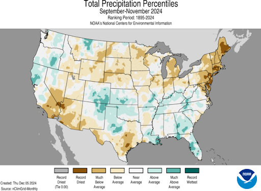
The contiguous U.S. autumn precipitation total was 6.23 inches, 0.65 inch below average, ranking in the driest third of the September–November record.
Precipitation was below average from the Southwest to the northern Plains and into the Great Lakes and Northeast. It was also drier than average across a large portion of Texas. Delaware, New Jersey, Connecticut, and Maine each ranked driest on record for this three-month period. Autumn precipitation was above average along portions of the West Coast and from the central Rockies to parts of the Southeast.
The Alaska autumn precipitation ranked in the driest third of the record with wetter-than-average conditions observed across eastern and northern portions of the state and average to dry conditions dominating in the west and south, with a record-dry autumn in the Aleutians.

Winter Temperature Outlook
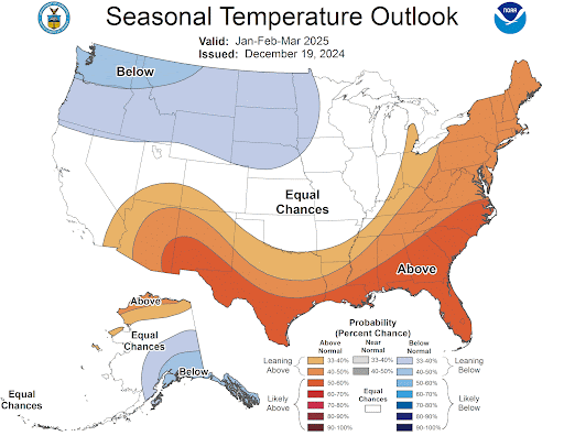
The January 2025 Temperature Outlook features above-normal temperatures over the southern half of the western contiguous United States (CONUS), Southern Plains and the East Coast.
This pattern is fairly typical of La Niña, and reflects dynamical model predictions that favor a La Niña-like response for the month. However, given the expected transient height pattern during the month, probabilities are overall low for temperatures. Probabilities are enhanced over the Southern Plains where there was the best agreement among available tools. Some models such as the C3S suite and CFSv2 favored higher probabilities of above normal temperatures over the Southwest; however, NMME and statistical tools that include decadal trends—which are below normal in parts of the Southwest—more strongly favor near-normal temperatures. Given this discrepancy, a weak tilt toward above-normal temperatures is favored despite some of the model results showing stronger probabilities in the region, which also aligns with forecasted below-normal precipitation in the region. Similarly, some models indicate stronger probabilities for above-normal temperatures over the East Coast relative to the Outlook, but given Week 3–4 models that tilt toward below-normal temperatures over the East, probabilities are again weakened. Equal chances (EC) of above-, near-, and below-normal temperatures are favored over the northern tier of the CONUS and Central Plains, where tools had weak or uncertain signals; moreover, both the Madden–Julian Oscillation and La Niña may lead to cold air intrusions into the region, though both influences are currently somewhat uncertain. In addition, given the forecasted warm start to the month of January, it is uncertain if periods of colder temperatures will be strong or long enough to tilt the probability to below normal over the northern tier. Over Alaska, most models favored above-normal temperatures—particularly CFSv2—and as such, a tilt toward above-normal temperatures is indicated in the Outlook.

Winter Precipitation Outlook
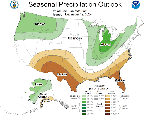
The January 2025 Precipitation Outlook thus resembles a La Niña-like pattern, featuring enhanced probabilities of above-normal precipitation over the Intermountain West and parts of the Northern and Central Plains, the Great Lakes, and interior Southeast, and a tilt toward below normal precipitation from the Southwest along the southern CONUS and parts of the coastal Southeast. Over Alaska, above-normal precipitation is favored for western and northern parts of the state, with a small area of below-normal precipitation over its southern coast. Some uncertainty exists along the West Coast where EC is indicated. NMME and C3S favor below-normal precipitation over the southern West Coast and above-normal precipitation over the northern West Coast, while CFSv2 tilts toward below normal over the northern West Coast. Given the potential for periods of above-normal precipitation over the West Coast during winter months, EC is favored despite some of the tools leaning toward below normal. Models and tools also had mixed signals along the coastal northeast and New England, and there is potential for variability during the month due to uncertainty in storm tracks, leading to the favored region of EC. Finally, over Alaska, below-normal precipitation is favored over its southern coast given La Niña teleconnections, and above normal is favored over the western and northern parts of the state given La Niña teleconnections, dynamical model agreement, and above-normal decadal trends over the northern coast.

Impacts and Outlooks for Your Region
Get more details for your region in the December 2024 climate impacts and outlooks summaries:
Prairies and High Plains Region
Alaska and Northwestern Canada Region
Creating These Quarterly Summaries
NOAA’s Regional Climate Services lead the production of these quarterly summaries of climate impacts and outlooks for various regions of the United States as well as parts of Canada along the border. This effort, which began in 2012, includes 13 unique regional products that are produced collaboratively with partner organizations.
You can access all of the Climate Impacts and Outlooks summaries as well as additional reports and assessments through the U.S. Drought Portal Reports web page at Drought.gov.


