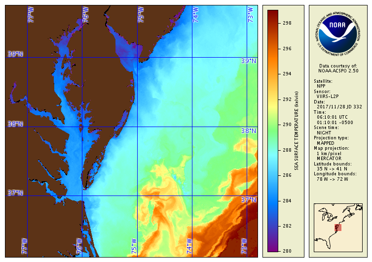
SST Image of Chesapeake Bay obtained from SNPP VIIRS on 28 November
2017 (night overpass). An unprecedented spatial resolution and radiometric
performance of the VIIRS sensor results in a very high quality SST imagery.
More images from VIIRS and other sensors over 27 regions selected in
conjunction with ACSPO users are available from the NOAA ACSPO Regional
Monitor for SST (ARMS) near-real time system
https://www.star.nesdis.noaa.gov/sod/sst/arms/.
Advanced Clear Sky Processor for Ocean (ACSPO)
Algorithm Description
Advanced Clear Sky Processor for Ocean (ACSPO) is the NOAA Enterprise SST system. It is currently used to produce a consistent line of SST products from several VIIRS, AVHRR FRAC and GAC, MODIS, ABI, and AHI sensors, flown onboard polar (SNPP/NOAA-20, Metop-A/B, NOAA-16 to 19, Terra/Aqua) and geostationary (GOES-16, Himawari-8) satellites. Two products are produced from each platform/sensors, in a community-consensus Group for High-Resolution SST (GHRSST) Data Specification version 2 (GDS2) NetCDF format: L2P (in original swath projection) and L3U (gridded uncollated 0.02deg resolution). Two-week rotated buffers of each ACSPO product are available in Near-Real Time (NRT) via the NOAA Coast Watch site, along with two reprocessed (Reanalyses, or RAN1) products: from SNPP VIIRS (Mar 2012 - 15 Dec 2015) and from AVHRR GAC onboard multiple NOAA and Metop satellites (Aug 2002- pr).
SST is used in many applications including monitoring of climate variability, operational weather and seasonal forecasting, military and defense operations, validation and/or forcing of the ocean and atmospheric models, ecosystem assessment, tourism, and fisheries. Satellite SST retrievals are assimilated into climate, mesoscale atmospheric, and sea surface numerical models, which form the cornerstone of the operational ocean forecasting systems.
Key Users (NOAA):
- STAR (Geo-Polar Blended SST)
- STAR (Coast Watch)
- STAR (Coral Reef Watch)
- NCEP (HYCOM/NCODA, RTG)
- NOS (West Coast and Chesapeake Bay Ocean Forecast Systems)
- NCEI (Optimal Interpolation "Reynolds" SST)
- NMFSC (West Coast, East Coast, Hawaii, Alaska)
Key Users (National/International):
- Canadian Met Centre (CMC)
- UK Met Office
- Australian Bureau of Meteorology
- Danish Meteorological Institute
- University of Melbourne
- Japan Met Agency
- University of Maryland
- Digital Globe, Inc. (supports US Fisheries)
Algorithm PI
- Principal Investigator
Alex Ignatov
Operational Product Access
Monitoring and Algorithm Support
- SST Quality Monitor (SQUAM)
- In situ SST Quality Monitor (iQuam)
- ACSPO Regional Monitor for SST (ARMS)
- Monitoring of IR Clear-sky Radiances over Ocean for SST
Archive and Data Repository
Relevant External Links
List of satellite/instruments for algorithm
- VIIRS (S-NPP, NOAA-20)
- AVHRR GAC (NOAA-16 to -19, MetOp-A/B)
- AVHRR FRAC (MetOp-A/B)
- MODIS (Terra, Aqua)
- ABI (GOES-16)
- AHI (Himawari-8)
