NOAA Center for Satellite Applications and Research banner
 

STAR in the News

News Items from the Recent Past...

photo: Hurricane Francine, September 10, 2024

Tracking Francine’s Latest Path

September 12, 2024 - Bloomberg News reports: Francine is the third named storm to hit the mainland US this year. The 2024 Atlantic hurricane season got off to a quick start, but had stalled in recent weeks before Francine. It has now produced six storms, four of which became hurricanes.

STAR's GOES-East geocolor image of the storm is featured.

Read more in the Bloomberg News story.

photo: Marshall Colorado Wildfire, December 2021

AI and satellite imaging doing early wildfire detection in Colorado

July 30, 2024 - This week the Denver Post reports on a new artificial intelligence program — the Next Generation Fire System — which will help identify wildfires as small as an acre by scanning images taken by weather satellites orbiting about 22,000 miles above the Earth’s surface. NOAA officials say it can process the deluge of data from the satellites — which capture images as frequently as every 30 seconds — and detect heat from fires smaller than a football field. The program then flags potential new fires to a dashboard so humans can check the images and verify the existence of a fire.

While humans are great at detecting a new fire from satellite images, they can’t process the firehose of data as quickly and easily as the AI program, said STAR's Mike Pavolonis, NOAA Satellites’ Wildland Fire Program manager.

Read more in the Denver Post story.
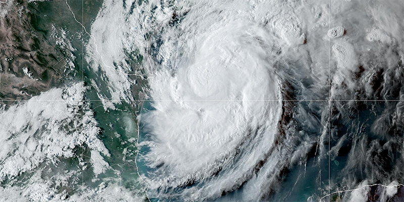
photo: Yucaipa Wildfire, California, 2024

Forecasters test new way to warn people near wildfires

July 27, 2024 - The Washington Post reports on testing of the Next Generation Fire System during a historic spate of wildfires in the Texas Panhandle and Oklahoma in February. During the outbreak, local meteorologists had been training on this new way to warn people about fast-spreading fires. As relentless winds spread flames through tinder-dry grass and brush, the National Weather Service issued 20 “Fire Warnings,” to let people know about fires’ locations and where they were moving. More than 400 structures were destroyed and two people were killed in those fires, though the warnings may have helped prevent further impact.

Read more in the Washington Post story.

photo: Colorado wildfire, 2021

How AI and satellite imaging are helping detect wildfires before they grow

July 31, 2024 - While humans are great at detecting a new fire from satellite images, they can't process the data as quickly and easily as the AI program, said Mike Pavolonis, NOAA Satellites' Wildland Fire Program manager. "The first step in wildland fire management is to know the fire is there," he said.

Read more in the Phys.Org.


pFad - Phonifier reborn

Pfad - The Proxy pFad of © 2024 Garber Painting. All rights reserved.

Note: This service is not intended for secure transactions such as banking, social media, email, or purchasing. Use at your own risk. We assume no liability whatsoever for broken pages.


Alternative Proxies:

Alternative Proxy

pFad Proxy

pFad v3 Proxy

pFad v4 Proxy