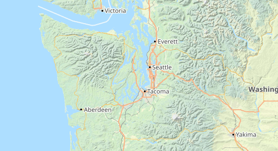
Outdoors – A map for developers
Save hours of your time reworking generic, bland maps to make them suitable for outdoors activities. We’ve already done the work for you.
Outdoors is carefully tailored to show hiking routes, ski runs, and topographical features.
Free plan available - no credit card required
An outdoor map for web apps and mobile devices
Designed to be easy to read in hilly, mountainous and backcountry areas.

Hand-curated Detail
Make sure your customers know what to expect so they can be confident in their plans
Trails, natural features, and amenities - like chairlifts & accomodation options - are prioritised.
Hiking paths are graded by difficulty (using the SAC scale). As the difficulty increases, the paths turn from black to red and the dashes shorten until they become dots.

Thoughtful Design
Make it easy for your customers to stay on track with easy to read maps
All design – from the background and elevation colouring to land use and buildings – has been carefully selected to make them easy to navigate for athletes, adventurers and tourists.
Terrain features and elevation are easy to recognise, while icons and labels are clearly visible on small screens.
Cartographer and company founder
Andy Allan
“Outdoors was the fourth style that we designed. I wanted to create a counterpart to OpenCycleMap, but where the main focus would be on hiking and walking routes, rather than cycling routes. I also wanted them to be visually distinct from each other.
I started from scratch with a whole new set of colours, both for the background and elevation colouring, but also for land use, buildings and so on.”

Regular Updates
Regular improvements mean your customers will always have the most recent information
We operate a policy of continuous improvement, whether that means implementing changes from our source material (OpenStreetMap) or making our own changes.
We recently improved our display of wetlands, for example.
Available in our maps APIs:
Created in-house using our Vector Sources API:
Use Cases
The Outdoors map helps your end users navigate outdoor locations anywhere in the world.
- Hiking and trekking apps
- Skiing apps
- Backpacking apps
- Backcountry apps
- Tourism and rental apps
- Warning apps (avalanche, and so on)
- Dog tracking apps
- Cycling apps