
If you are looking for fresh snow by Christmas morning or are curious about potential travel disruptions, the best chances for at least 1" of new snowfall early this week exist across the mountainous West, Great Lakes, and Northeast. Otherwise, temperatures this last full week of December will average above normal for much of the lower 48 states. Read More >

Synopsis:
The winter of 1966-1967 had been a harsh one. In fact, it was a record setting winter. The record 23 inch snowstorm of January 26 and 27 led to Chicago’s snowiest winter, with a total of 68.4 inches. (The current record of 89.7 inches was set in 1978-1979). There was continuous snow cover on the ground from January 26 until March 9, a 42 day stretch! But the weather pattern had changed by late March and April. Spring had arrived. Chicago saw five straight days in the 70s the previous weekend - April 13 through 17. Rockford even hit 80 degrees during the mid-April warm spell. People in northeast Illinois were looking forward to another mild spring weekend Friday April 21.
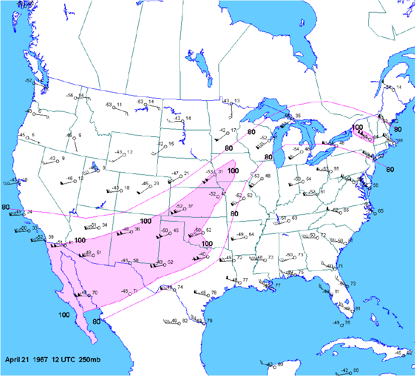
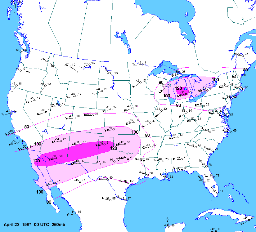
Friday morning, April 21 a strong west-southwest upper level jet stream was in place from the southwest U.S. to the Great Lakes. At 500 millibars (about 18,000 feet) a short wave trough was moving rapidly northeast from the southwestern U.S. In response to the short wave, at the surface a wave of low pressure developed over the central Plains and moved northeast along a nearly stationary front which was draped across the Midwest. As the wave of low pressure approached northern Illinois, the stationary boundary surged north of Chicago as a warm front, bringing mild and humid air to the area. Temperatures climbed into the low to mid 70s across north and central Illinois on strong south winds and dew point temperatures reached the lower 60s. As the wave of low pressure approached during the warmth of the afternoon, surface winds backed slightly to the south-southeast. This likely increased the low level wind shear – the change of wind speed and direction with height - an important factor in producing rotating supercell thunderstorms and tornadoes. By late afternoon the mid level short wave was approaching and the upper level jet maximum of 120 knots (250 millibars or around 34, 000 feet) moved into the upper Great Lakes, which put northeast Illinois in the right-rear region of the jet – a favorable location for vertical development of thunderstorms.
This fatal combination of factors led to explosive development of rotating supercells along a line of storms that was moving across northern Illinois that afternoon. This line had already produced wind damage and tornadoes across Missouri, Iowa and northwest and north central Illinois. It would continue producing tornadoes across lower Michigan into the evening. But by far the most devastating tornadoes occurred in northeast Illinois and the Chicago area during the mid and late afternoon.
 |
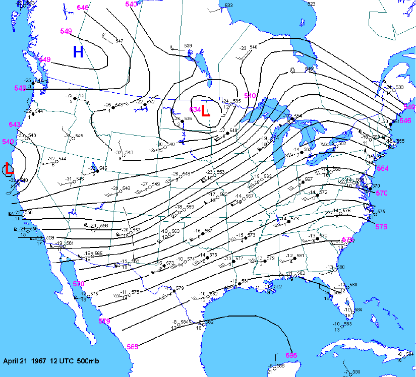 |
| 250 mb map at 12Z (700 am CDT) | 500 mb map at 12Z (700 am CDT) |
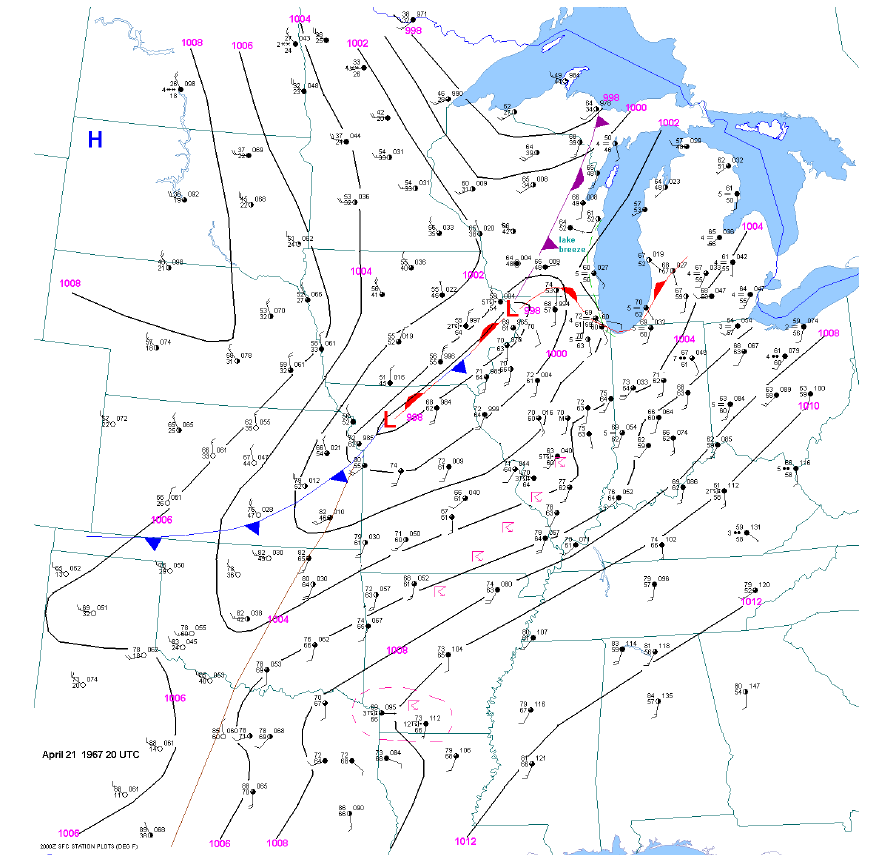 |
| Surface map at 20Z (300 pm CDT) |
 |
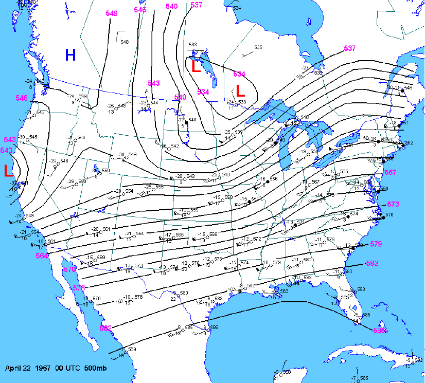 |
| 250 mb map at 00Z (700 pm CDT) | 500 mb map at 00Z (700 pm CDT) |
In the wake of the storms, much colder air poured into the area on northwest winds. Two days later northern Illinois had a very rare late April snow! A total of 3.8 inches fell at Rockford and 3.1 inches fell at Chicago (Midway) on April 23. This is the latest 3 inch snow on record for both locations.

The Belvidere Tornado
The tornado first struck at 350 PM two miles southeast of Cherry Valley. The tornado passed the Chrysler plant near I-90 where 300 new cars and 100 employee cars were destroyed. The tornado continued east northeast through the southeast side of Belvidere. One hundred twenty seven homes were destroyed, and hundreds more were damaged. The most notable and horrific part of this tornado was the mayhem at the Belvidere High School. Buses had already picked up the elementary school children and were loading the high school students when the tornado struck. Twelve buses were rolled over. Students were flung like leaves into the muddy field. Thirteen of the 24 fatalities and 300 of the 500 injuries in this tornado occurred at the high school. According to Tom Grazulis of The Tornado Project, this was the nation’s sixth worst school death toll from a tornado. (Numbers one and two were also in Illinois - from the great Tri-State Tornado of 1925.) The tornado ended in McHenry County, about two miles north of Woodstock.
|
Tornado - BELVIDERE
|
||||||||||||||||
|
The Lake Zurich Tornado
At 503 PM another tornado struck Fox River Grove, North Barrington, and Lake Zurich. Lake Zurich Manor, a subdivision 1 1/2 miles northwest of the center of town was hardest hit. Around 75 homes were completely destroyed. Another 200 homes had extensive damage. Seth Paine School was destroyed. Acorn Acres, a new subdivision of luxury homes northeast of Lake Zurich Manor had spotty damage and debris. About a dozen homes had extensive damage. More homes had extensive damage in Hawthorne. At Gilmer and Route 63, four homes, a brewery and a plastic factory were destroyed. Much of this area was rolling wooded hills where there were large trees damaged. Several residents who were interviewed saw no noticeable funnel or roar until it was upon them, just heavy low black clouds swirling.
|
Tornado - LAKE ZURICH
|
||||||||||||
|
|
The Oak Lawn Tornado
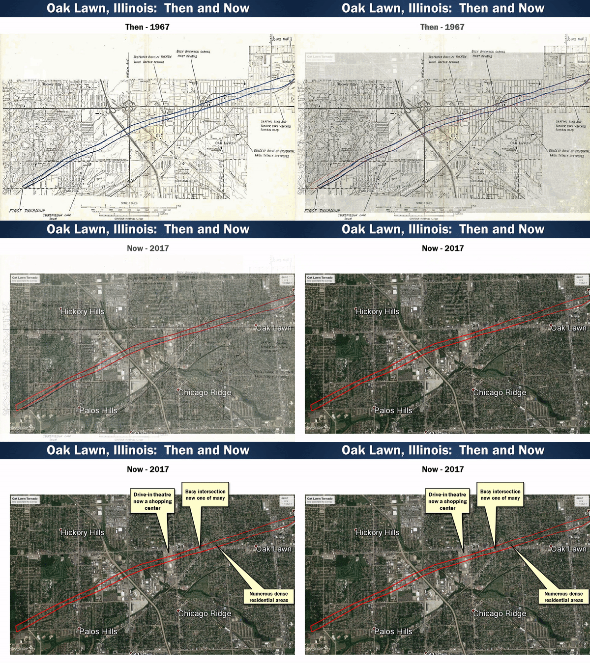
The worst storm of the day was approaching the southwest suburbs around 500 PM. At 515 an off duty Weather Bureau employee 10 miles north of Joliet saw a rotating cloud mass over his house near Route 53 and Naperville Road which is now Romeoville. Minutes later a restaurant at McCarthy Road and 127th Street in Lemont had its windows blown out. At 524 PM an observer at The Little Red School House at 99th and Willow Springs Road observed a lowering funnel just to his south. This was the first report of the funnel to the Weather Bureau. (The Weather Bureau employee couldn't get through.) The Little Red School House observer said, "My ears popped, the building shook and cars in the parking lot bounced”. The funnel passed LaGrange Road and Kean Avenue just south of 107th Street. The tornado touched down just east of 88th Avenue between 105th and 106th Streets at 524 PM (24 minutes after the tornado warning was issued for Cook County!) This is now the site of Morraine Valley Community College. The tornado destroyed trees, bent power poles and picked up mud for the first part of its journey. The tornado hit its first homes around 83rd Avenue and 103rd Street. The tornado crossed the Tri-State Tollway and then hit an area of homes near Harlem Avenue and 98th-99th Streets. The tornado then hit a drive in movie theater near Chicago Ridge an hour before it was set to open. The screen’s steel supports were bent and speakers and speaker stands were pulled from the ground.
The tornado then moved into the heart of Oak Lawn where it did the most severe damage. The tornado was a block wide at this point. Many homes were leveled. The busy intersection of 95th Street and Southwest Highway was clogged with Friday evening traffic when the tornado struck. Twenty five to 40 cars were thrown in all directions. The greatest death toll occurred in this area. The high school was hit as well a bus garage. Buses were thrown like toys, one landing on a house. The tornado weakened slightly from here but intensified again near Cicero Avenue and 92nd Street where a mobile home park and roller skating rink were leveled. The tornado then ripped through Hometown.
It swept across St.Mary's Cemetery, knocking down 200 monuments. It then moved on to Evergreen Park. It weakened slightly through this area. It moved through Beverly Hills Country Club and Dan Ryan Woods. It hit a more populated area again near 87th and Damen Ave. Damage was mostly to trees, roofs, windows, and garages. It crossed Halstead near Vincennes Ave where it damaged apartments and factories. The tornado crossed the Dan Ryan Expressway at 535 pm, flipping a semi. There was so much debris thrown on the highway that it had to be closed for hours. Damage was lighter beyond this point - mostly roofs, chimneys, and windows. The path widened and became more diffuse as the storm approached Lake Michigan. The final report was at the water filtration plant at 78th and the lakefront, where a 100 mph wind gust was recorded. The tornado made the 16.2 mile trek in 15 minutes, moving across the ground at over 60 mph!
In the aftermath, 800 National Guard troops were brought in to search for bodies and keep out sight-seers. One hundred thousand customers were without power. President Johnson declared tornado ravaged communities a Disaster Area. The Salvation Army and American Red Cross provided food and shelter to the homeless.
|
Tornado - OAK LAWN
|
||||||||||||||||
|
Other Tornadoes:
Details of the other tornadoes that day are not as complete. Here is a list of other tornadoes that occurred in the area that day;
Personal Accounts
For numerous detailed accounts as well as the impacts that this day had, please take some time and read the full accounts below:
Presentations
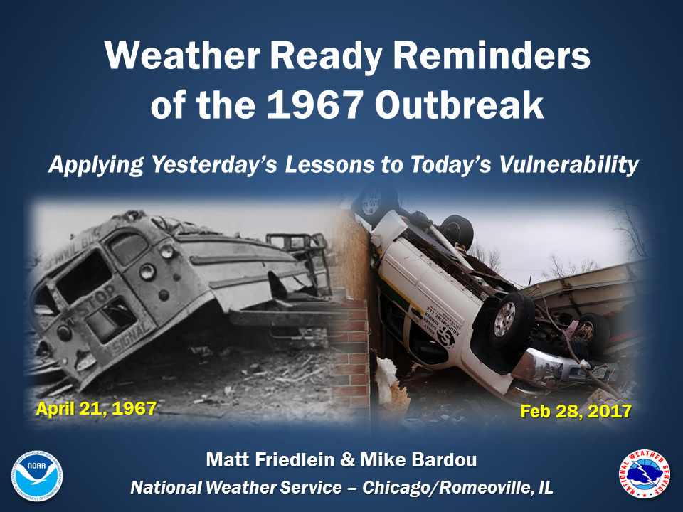
NWS Chicago personnel have given several presentations that relate to the April 1967 tornado event. The presentations are below for you to view.
 |
 |
 |
Links
Credits
Information about the tornado tracks from NOAA National Weather Service and Tom Grazulis, “Significant Tornadoes 1680-1991”.
Weather maps provided by Jonathon Finch, NOAA NWS Dodge City.
Black and white aerial photos of storm damage from T. Lebaron, Oak Park, IL.
Color storm damage photos from Dr. T. Fujita, University of Chicago, courtesy Brian Smith, NOAA NWS Omaha, NE.
Photographs of Oak Lawn Tornado – courtesy Oak Lawn Public Library.
 |
Media use of NWS Web News Stories is encouraged! Please acknowledge the NWS as the source of any news information accessed from this site. |
 |