聖奧爾本斯市
外观
| St Albans City and District | |
|---|---|
| 非都市區,自治市鎮,市 | |
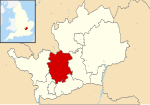
 聖奧爾本斯市在赫特福德郡的位置 | |
| 坐标:51°47′N 0°20′W / 51.78°N 0.33°W | |
| 國家 | 英國 |
| 構成國 | 英格蘭 |
| 區域 | 東英格蘭 |
| 非都市郡 | 赫特福德郡 |
| Admin HQ | 聖奧爾本斯 |
| 成立於 | 1974年4月1日 |
| 政府 | |
| • 类型 | 非都會區議會 |
| • 行政机构 | 聖奧爾本斯市議會 |
| • Leadership | Leader & Cabinet |
| • MPs | Anne Main Peter Lilley |
| 面积 | |
| • 总计 | 62.23 平方英里(161.18 平方公里) |
| 人口(2022年中估計) | |
| • 民族 | 90.9% 白人 4.1% 南亞人 1.7% 黑人 1.9% 混血 1.4% 中國人或其他 |
| 时区 | GMT(UTC0) |
| • 夏时制 | BST(UTC+1) |
| ONS編碼 | 26UG (ONS) E07000100 (GSS) |
| OS格網參考 | TL148073 |
| 網站 | www |
聖奧爾本斯市,全称聖奧爾本斯市和區(英語:St Albans City and District,/ˈɔːlbənz/),是英國赫特福德郡的一個非都市區、自治市鎮和市,由聖奧爾本斯市議會管轄。
歷史
[编辑]聖奧爾本斯市創立於1974年4月1日,是由原先的聖奧爾本斯市自治市和哈普敦都會區及大部分聖奧爾本斯郊區合併而成的。此地的城市地位要追溯到1877年因聖奧爾本斯大教堂建立而給予聖奧爾本斯的市自治市(municipal borough)地位。[1] 聖奧爾本斯市則是在1974年7月9日經由英皇制誥而得到城市地位的。[2]
參考文獻
[编辑]