|
Rip Currents |
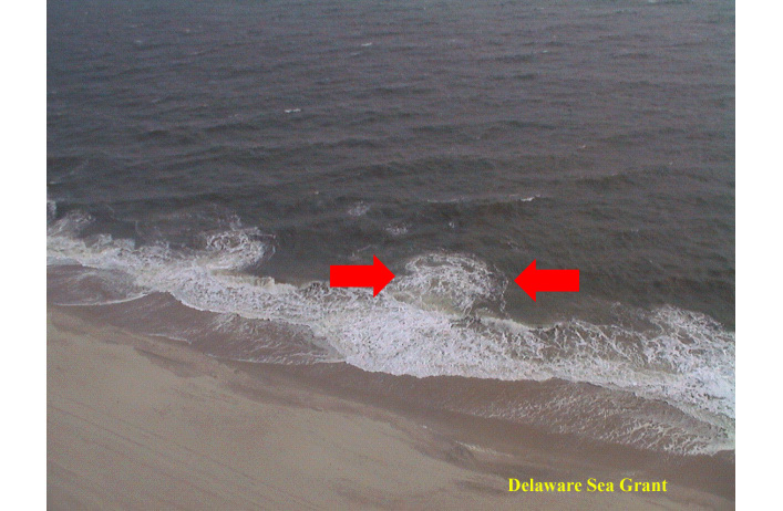
 Rip currents most typically form at low spots or breaks in sandbars, and also near structures such as groins, jetties and piers. Rip currents can be very narrow or extend in widths to hundreds of yards. They can also be very deep that unsuspecting swimmers can step into the channel and sink over their head and drift with the current. The pull of rip currents toward open water varies: sometimes the rip current ends just beyond the line of breaking waves, but sometimes rip currents continue to push hundreds of yards offshore. Rip currents are powerful, channeled currents of water flowing away from shore. They typically extend from the shoreline, through the surf zone, and past the line of breaking waves. Rip currents can occur at any beach with breaking waves, including Great Lakes beaches.
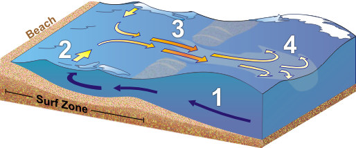
Rip currents form as incoming waves create an underwater sandbar close to shore (#1 above), and the waves push more and more water in between the sandbar and the shore (#2) until a section of this sandbar collapses and the water rushes back toward the open water (#3) through a narrow gap. Once the flowing water passes through the narrow gap, it begins to spread out (#4). It is here where the velocity and strength of the rip current circulation begins to weaken considerably.
Dispelling the Myth of the Rip
A rip current is a horizontal motion not a vertical motion. Rip currents do not pull people under the water; they pull people away from shore. The rip current is typically the strongest about a foot off of the bottom, which can cause your feet to be knocked out from under you making it feel like something under the water was pulling you. This is where the incorrect term "undertow" comes from.
Also, another incorrect term used for rip currents is the "rip tide" commonly heard on ocean beaches. Rip currents would exist with or without tides. However, low tide can enhance the intensity of the current.
Learn More About Rip Currents from the United States Lifesaving Association and NOAA (9 Minute Video)
Rip Current Forecasts for Lake Erie
 |
Starting on Memorial Day weekend, and continuing through the summer, NOAA's National Weather Service Forecast Office in Cleveland adds rip current information to some of the weather forecast and outlook products when there is an increased risk of rip currents along the shoreline of Lake Erie.
During the Rip Current Season...
When there is either a Moderate or High risk for rip currents along the Lake Erie shoreline between Maumee Bay and Ripley, NY, NWS Cleveland will highlight this increased risk in our morning Hazardous Weather Outlook (HWO) and in our Nearshore Marine Forecast. In addition, a Lakeshore/Coastal Hazard Message will be issued especially for those times that the rip current risk is determined to be High.
· Low Risk of rip currents. Wind and/or wave conditions are not expected to support the development of rip currents; however, rip currents can sometimes occur, especially in the vicinity of groins, jetties, and piers. Know how to swim and heed the advice of lifeguards.
· Moderate Risk of rip currents. Wind and/or wave conditions support stronger or more frequent rip currents. Only experienced surf swimmers should enter the water.
· High Risk of rip currents. Wind and/or wave conditions support dangerous rip currents. Rip currents are life-threatening to anyone entering the surf.Note: When you arrive at the beach, speak with on-duty lifeguards about rip currents and all other water conditions expected for the day.
When NWS Cleveland meteorologists forecast a moderate or high risk of rip currents on the shoreline of Lake Erie from Maumee Bay to Ripley, NY, a statement will be included in the “Today” section of the Hazardous Weather Outlook stating that there is an increased risk of rip currents. A statement will also be placed in the Nearshore Marine Forecast. When there is a high risk of rip currents, a Lakeshore Hazard Message will also be issued.
When there is an increased risk of rip currents, beachgoers should take extra precaution and follow safety rules or simply stay out of the water period. However, it should be noted that even when there is not an increased risk of rip currents forecast, beachgoers should always use caution when swimming as rip currents can occur at anytime when waves of any size are present, especially near fixed structures such as piers, groins or jetties.
For more information on rip currents, please look at the NOAA/NWS Rip Current Brochure, or visit:
NOAA’s NWS Rip Current Awareness Page
NOAA SeaGrant Michigan Rip Current Page