|
Contents Of This Report: |
|
National Drought Overview
|
|
[top]
Detailed Drought Discussion
Overview
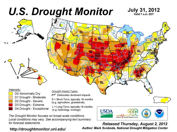
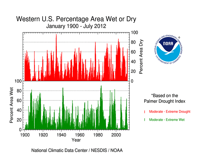
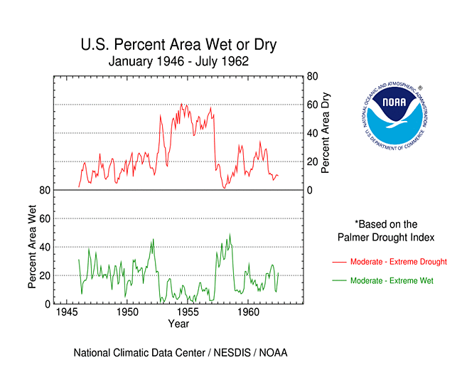
July 2012 was another warmer- and drier-than-average month (warmest and 28th driest July on record, based on data back to 1895) when weather conditions are averaged across the country. A strong high pressure system (High, or upper-level ridge) kept its stranglehold over much of the U.S. for most of the month, resulting in persistent warm anomalies (weeks 1, 2, 3, 4) which dominated most of the country. Descending air ("subsidence") associated with the High inhibited precipitation in the central states, but a few cool fronts triggered areas of rain along the southern and eastern peripheries of the High, and monsoon showers brought rain to its western periphery (weeks 1, 2, 3, 4). The dry weather, in combination with increased evaporation caused by the record heat, expanded drought conditions in the West, Great Plains, and Midwest, while below-normal rainfall expanded drought conditions in Hawaii. Nationally, the moderate-to-exceptional (D1-D4) drought footprint increased to about 53 percent of the country while the percentage in the abnormally dry to exceptional drought category generally held steady at about 71 percent. About 19 percent of the country was in the worst drought categories (D3-D4, extreme to exceptional drought), more than double the percentage from last month. The Palmer Drought Index, whose data base goes back 113 years, is relied upon for drought comparisons before 2000. The July 2012 Palmer value of 57 percent is the largest percentage since December 1956 when 58 percent of the contiguous U.S. was in moderate to extreme drought.
By the end of the month, the core drought areas in the U.S. included:
- a large area of moderate (D1) to exceptional (D4) drought stretching from the central Rockies, across the central and southern Plains, into the Ohio Valley and southern Great Lakes;
- an area of moderate to exceptional drought in the Southeast;
- an area of moderate to severe (D2) drought in the Mid-Atlantic, with areas of moderate drought in the Northeast;
- an area of moderate to extreme drought across much of the West; and
- much of Hawaii, where moderate to extreme drought persisted.
Historical Perspective
As noted in more detail in the Historical Analog section below, the droughts of the 1930s were largely a succession of expansions and contractions, characterized as "waves" of very intense drought spreading over huge expanses of the country, then retreating to a relatively small epicenter. The first huge drought expanded from the eastern U.S., but by the middle of the decade drought waves expanded from the Plains. These were the widely-known "Dust Bowl" days. The 1950s were much more persistent in their coverage. The 1950s drought dominated the early to middle decade, expanding and retreating (but more slowly) with the epicenter in the Southern Plains, particularly Texas and New Mexico, and into adjacent areas of Mexico. Much of the South and Gulf Coast was seriously involved in this drought regime. At its peak, most of the country was involved in the drought. Most drought was eradicated during a very wet 1957. The droughts of the 2000s were large, intense, regional events, and did not emanate from, or return to, the same regions in the way that the droughts of the 1930s and 1950s did. Compared to the "Drought Decades" of the 1930s and 1950s, the drought features were smaller in size and more migratory from one part of the country to another, but their intensity was strong. However, the western U.S. did see persistent drought during the first half of the decade.
Palmer Drought Index
The Palmer drought indices measure the balance between moisture demand (evapotranspiration driven by temperature) and moisture supply (precipitation). The Palmer Z Index depicts moisture conditions for the current month, while the Palmer Hydrological Drought Index (PHDI) and Palmer Drought Severity Index (PDSI) depict the current month's cumulative moisture conditions integrated over the last several months.
 |
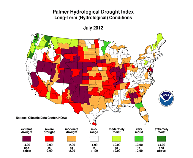 |
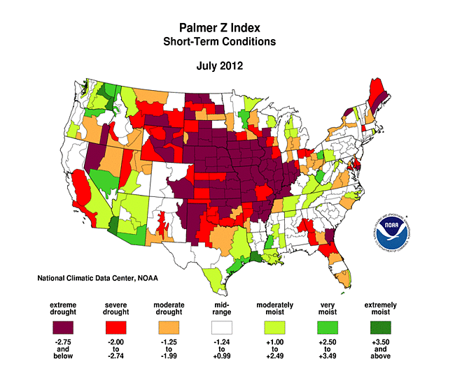
In some respects, the dryness of July intensified the long-term dryness which had become evident in June. As seen on the July 2012 Palmer Z Index map, low precipitation and record hot temperatures (with the accompanying increased evapotranspiration) led to short-term drought across much of the central part of the country this month. Wet conditions are evident on the Z Index map along the periphery of the dry area — in parts of the Great Lakes, Appalachians, Gulf of Mexico coast, Southwest, and Pacific Northwest. The Palmer Z Index map also indicates July dryness in parts of the East Coast. Compared with the June 2012 PHDI map, the July 2012 PHDI map indicates that drought conditions deteriorated from the central Rockies to Ohio Valley and Great Lakes, but improved along parts of the Gulf of Mexico coast and in the Southwest. The July 2012 PHDI map also reflects the long-term nature of the drought conditions. The Z Index and PHDI maps in combination show that precipitation brought relief to parts of the Southwest and Deep South drought areas, and parts of New England dried out, but for much of the rest of the country — drier-than-normal weather persisted over the existing drought areas and wetter-than-normal weather continued over parts of the already-moist Pacific Northwest.
Palmer Drought Model Potential Evapotranspiration
Did You Know?
Potential Evapotranspiration
The Palmer drought indices measure the balance between moisture demand and moisture supply. Drought results from an imbalance between these two components. Precipitation provides the water supply. Water demand is usually measured by evapotranspiration (the amount of water that would be evaporated and transpired by plants). There is a distinction made between potential evapotranspiration (PE) and actual evapotranspiration (AE). The Palmer model uses Thornthwaite's equations to estimate PE from temperature. PE is the demand or maximum amount of water that would be evapotranspired if enough water were available (from precipitation and soil moisture). AE is how much water actually is evapotranspired and is limited by the amount of water that is available. AE is always less than or equal to PE, so PE is used for the water demand component of the drought equation.
In the Palmer model, if the amount of precipitation (P) during the month is greater than PE for the month, then the leftover P soaks into the ground to recharge soil moisture, and any left over after that runs off as streamflow. If P is less than PE, then moisture has to be drawn out of the soil to meet the PE demand. Hotter temperatures result in greater PE which requires more P just to meet the greater demand. Climates where PE is always greater than P are termed arid climates. The American Southwest is a typical arid climate.
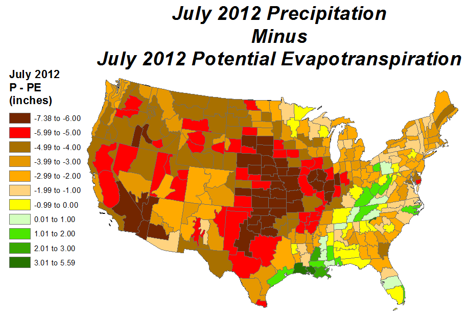
During July 2012, temperatures were much above normal across much of the country — from the Northern Rockies to the Northeast, across the Great Plains and into the Southeast — resulting in potential evapotranspiration (PE) values which exceeded five inches across most of the country, and seven inches across much of the Great Plains and Midwest agricultural belt. Precipitation (P) amounts were well below normal — less than three inches from the heart of the Midwest to the West Coast — resulting in P minus PE values (water supply minus water demand values) which went strongly negative and further sapped soil moisture reserves, stressed crops and other vegetation, and shrank streams. Even if normal precipitation amounts had occurred, it would not have been enough to meet PE demand in most areas.
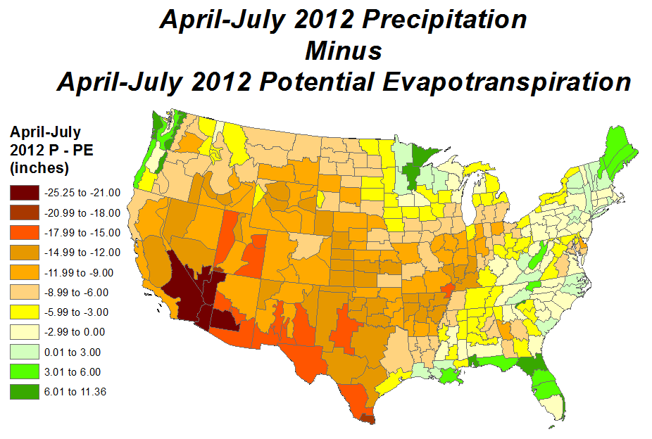
The hardest-hit areas (as measured by pasture, soil moisture impacts) are the Rocky Mountain states, Central Plains, and Ohio Valley. Aside from the normally arid West, these areas have had the least precipitation and smallest percent of normal precipitation during the April-July growing season. With the unusual warmth of the last four months, PE during April-July has been excessive. The precipitation deficits and extra PE during this season have sent P minus PE values well into negative territory during the important growing season in America's agricultural heartland. If normal precipitation had fallen during this time, P minus PE values would still have been negative for these agricultural areas, but the stress on crops would have been far less.
Standardized Precipitation Index
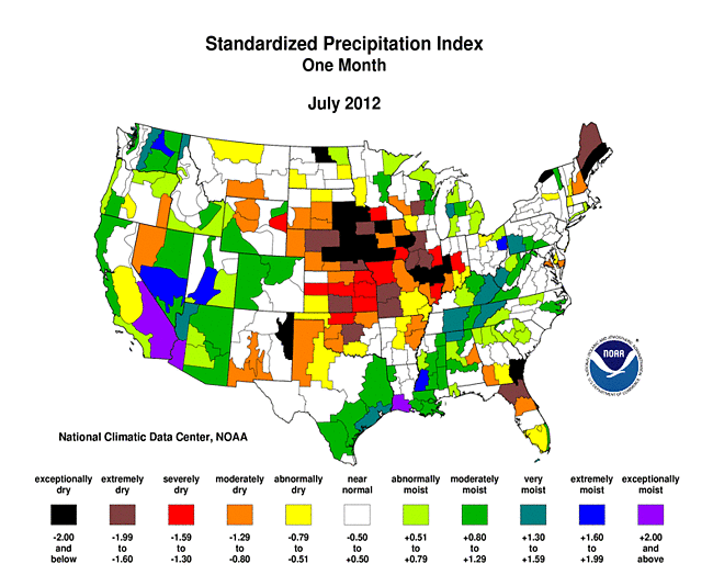
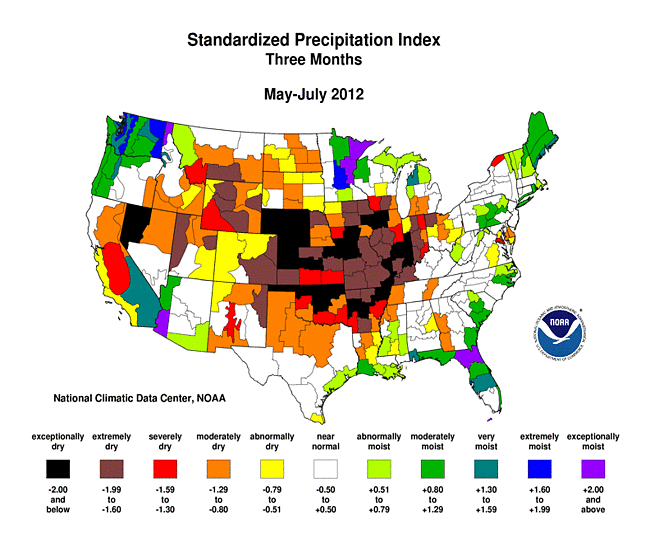
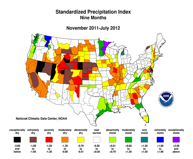
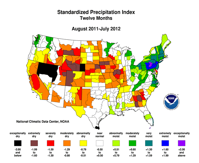
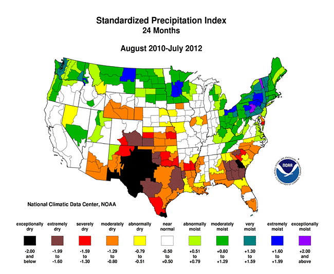
The Standardized Precipitation Index (SPI) measures moisture supply. The SPI maps here show the spatial extent of anomalously wet and dry areas at time scales ranging from 1 month to 24 months.
 |
 |
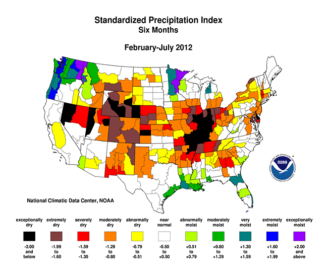 |
The 1-month SPI shows the domination of high pressure over the central part of the country, with very dry conditions surrounded by wet conditions along its periphery (as described earlier). Dryness in northern New England and the southeast corner of the country is also evident at the one month timescale. The persistence of the High over the central U.S. for the past several months is reflected by dry conditions from the Great Plains to Midwest at 2 to 6 months, with dryness also spread into parts of the West. At 6 and 9 months, two core areas of dryness begin to manifest, one centered over the Ohio Valley and the other stretching from the Central Plains to Intermountain Basin, with pockets of dryness in the East. At 12 months there are two areas of dryness, one in the Southeast and the other stretching from the West Coast to Midwest. The pattern at 24 months is largely wet conditions along the northern tier states and dryness in the southern states. The ring of wetness along the edges of the country, which surrounds the central core dry area, is evident from 1 to 3 months. Wetness is observed in the Pacific Northwest throughout most of the time scales, in New England at 2 and 3 months, and across the Northeast at 12 and 24 months.
 |
 |
 |
Agricultural and Hydrological Indices and Impacts
 |
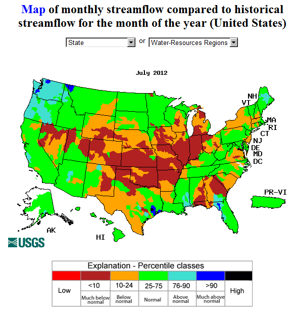 |
Drought conditions were reflected in numerous agricultural, hydrological, and other meteorological indicators, both observed and modeled.
Agricultural:
Based on July 30th U.S. Department of Agriculture reports, 48 percent of the nation's corn crop was rated in poor to very poor condition. This is more than twice the 22 percent at the end of June. Thirty-seven percent of the national soybean crop was rated poor to very poor (compared to 22 percent a month ago), 42 percent of sorghum (24 percent last month), and 57 percent of the nation's pasture and rangeland (43 percent last month). In some states, nearly all of the pasture and rangeland was rated poor to very poor (Missouri at 98 percent, Illinois at 95 percent). The drought has taken a toll on the nation's soil moisture, with virtually all of the topsoil in the Great Plains to Midwest core drought area short or very short of moisture.
- USDA (U.S. Department of Agriculture) observed soil moisture conditions, departures and percentiles, and comparison to 5-year average and 10-year average;
- the Palmer Crop Moisture Index (CMI), which intensified during the month in the central third of the country (weeks 1, 2, 3, 4);
- NOAA Climate Prediction Center (CPC) modeled soil moisture anomalies and percentiles for the end of the month, and soil moisture anomaly change compared to previous month;
- CPC's Leaky Bucket model soil moisture percentiles;
- NLDAS (North American Land Data Assimilation System) modeled soil moisture percentiles for the top soil layer and total soil layer;
- VIC (University of Washington Variable Infiltration Capacity macroscale hydrologic model) modeled soil moisture percentiles, and soil moisture percentile change compared to previous month;
- USDA observed pasture and rangeland conditions;
- Vegetation Drought Response Index (VegDRI);
- the NOAA/NESDIS satellite-based Vegetation Health Index (VHI);
- the USGS (U.S. Geological Service) agro-hydrologic model (Soil Water Index, Water Requirement Satisfaction Index);
Hydrological:
- USGS observed streamflow;
- CPC modeled runoff anomalies and percentiles;
- VIC 1-, 2-, 3-, 6-month, and water year to date runoff percentiles;
- NLDAS modeled streamflow anomalies and percentiles;
- NLDAS model runoff anomalies and percentiles;
- USGS groundwater observations (real-time network, climate response network, total active network);
- USDA reservoir storage as percent of capacity;
Meteorological:
- total precipitation (plotted by the USGS, NOAA National Weather Service [NWS], and NOAA High Plains Regional Climate Center [HPRCC]);
- percent of normal precipitation and precipitation percentiles (CPC, NWS, HPRCC station observations, Leaky Bucket model);
- NCDC statewide precipitation ranks;
- USGS number of days with precipitation and maximum number of consecutive dry days;
- temperature departures from normal (HPRCC) and temperature percentiles (CPC, Leaky Bucket);
- NCDC statewide temperature ranks; and
- number of record warm daily low temperatures, record daily high temperatures, record daily low temperatures, and record cool daily high temperatures, and all-time record high temperatures, set during the month (from NCDC's daily records analysis).
Regional Discussion
July 2012 was characterized by below-normal rainfall across much of the Hawaiian Islands. Abnormally dry to moderate drought conditions expanded into the northern islands this month, with moderate to extreme drought affecting about 54 percent of the state. Longer-term conditions continued drier than normal (last 2, 3, 4, 6, 12, 24, and 36 months, year-to-date, and water-year-to-date), especially for the southern islands.
In Alaska, July 2012 was generally drier than normal along a strip covering the central third of the state, wetter than normal along the west coast, and had a mixed pattern in the eastern sections. At short time scales (2, 3, 4, 6, and 7 months) relative dryness was significant in the north central sections, while at longer time scales a dry pattern at interior stations becomes evident (12, 24, and 36 months, and water-year-to-date). An area of abnormal dryness covered the northern areas on the USDM map.
Southern and eastern portions of Puerto Rico were drier than normal during July. These areas have been persistently drier than normal at longer time scales (2, 3 and 6 months, and year to date and water year to date). The July 31st USDM map had an area of abnormal dryness in the south central to eastern areas to reflect these rainfall deficits.
 |
 |
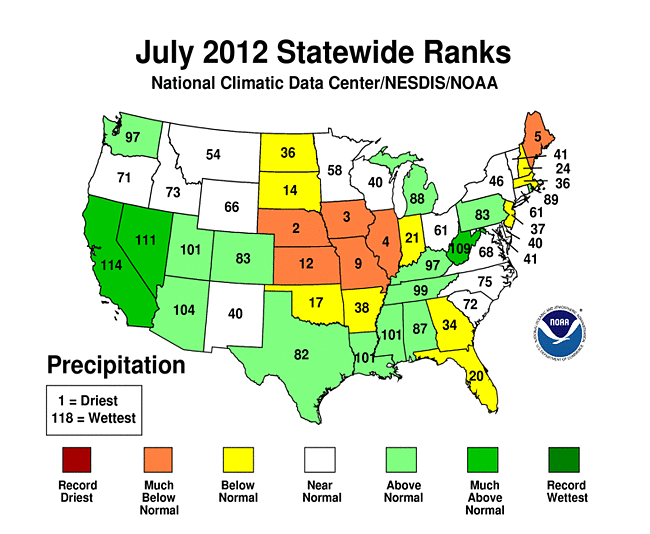
Over a tenth of the U.S. was very dry (the driest ten percent of the historical record) during July 2012. The national rank for July 2012 was the 28th driest July in the 118-year record. On a statewide basis, July 2012 ranked in the top ten driest Julys for five states — one of which was Maine, but four of them (Nebraska [second driest], Iowa [third], Illinois [fourth], and Missouri [ninth]) were in the Central Plains to Midwest agricultural belt under the influence of an upper-level high pressure ridge. Kansas, which ranked twelfth driest, was also affected by the ridge. Ten other states ranked in the driest third of the historical record.
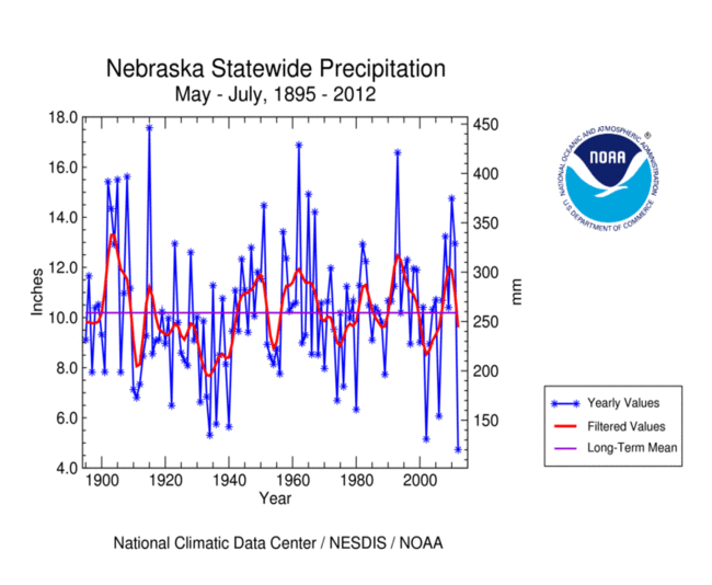
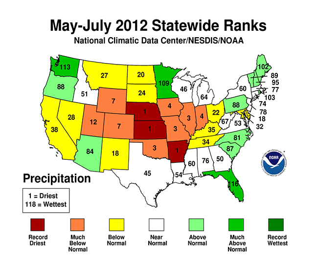
The spatial pattern of dryness was larger at the three month time scale. Arkansas, Kansas, and Nebraska each had their driest May-July on record, with seven other states (from the Central Rockies to Ohio Valley) ranking in the top ten driest category. Eleven other states ranked in the driest third of the historical record.
 |
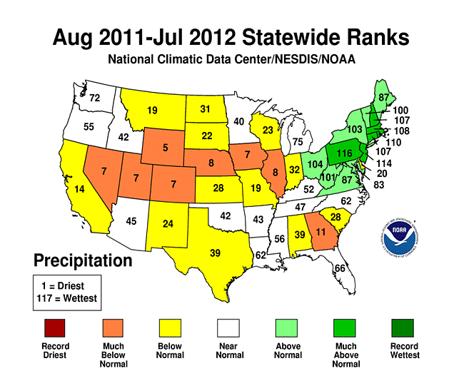 |
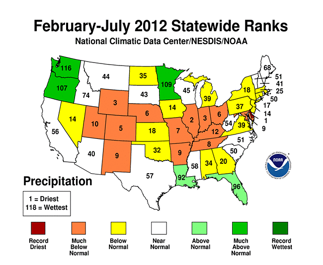
Three centers of dryness appear at the six month time scale — the Southwest to Central Plains, the Mid-Mississippi to Ohio valleys, and the Mid-Atlantic. Delaware had the driest February-July on record, Illinois second driest, and Indiana and Wyoming each third driest. In total, 13 states ranked in the top ten driest category for February-July, and another 15 were in the driest third of the historical record. A similar pattern was evident for the year-to-date. At the 12-month time scale, dryness dominates from the West to the Midwest and also in the Southeast. August 2011-July 2012 ranked in the top ten driest category for seven states, with 14 other states ranking in the driest third of the historical record.
 |
 |
 |
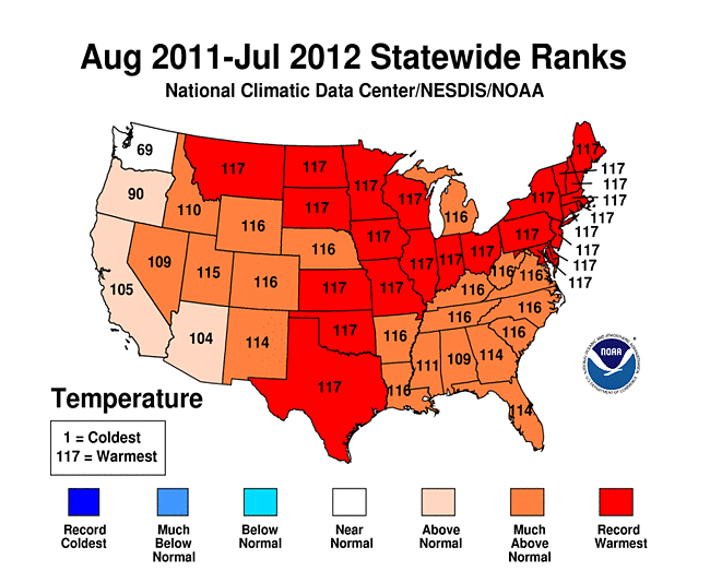 |
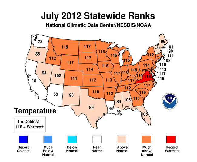
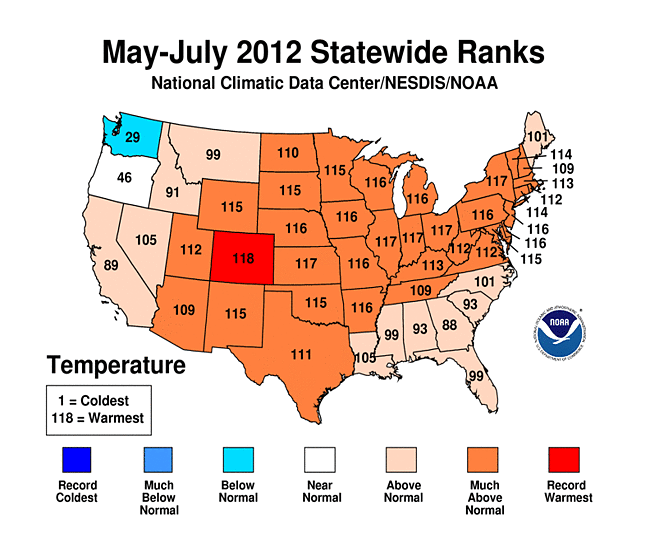
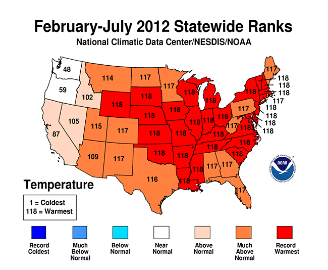
The dryness has been accompanied by abnormally warm temperatures at all time scales. July 2012 ranked as the warmest July in the 1895-2012 record for Virginia and second warmest for seven other states. In total, 32 states ranked in the top ten warmest category and an additional twelve ranked in the warmest third of the historical distribution. Colorado had its warmest June-July and May-July, 28 states had their warmest February-July, 33 had their warmest January-July, and 24 had their warmest August-July. For the last twelve months (August-July), only Washington state was not in the warmest third of the historical record or hotter.
As noted earlier, excessive heat increases evapotranspiration and exacerbates drought. The combination of heat and dryness drove the Palmer Z Index to record or near-record levels for the following states:
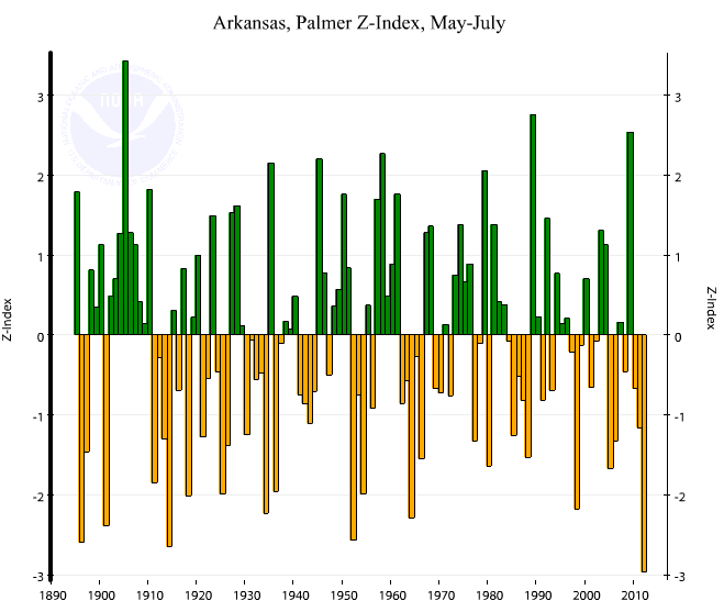
- Arkansas: the driest and third warmest May-July resulted in its most severe May-July averaged Palmer Z Index on record.
- Nebraska: the driest and third warmest May-July resulted in its second most severe May-July averaged Palmer Z Index on record (behind 1934).
- Kansas: the driest and second warmest May-July resulted in its third most severe May-July averaged Palmer Z Index on record (behind 1934 and 1956).
- Illinois: the third driest and second warmest May-July resulted in its second most severe May-July averaged Palmer Z Index (behind 1936).
Notably, Palmer Z Index value for May-July 2012 in Illinois was more severe than that for 1988, even though 1988 period was drier than that of 2012. The reason for this is May-July 1988 ranked only 19th warmest, thus illustrating the importance of temperature in exacerbating drought.
 |
 |
Corn and Soybean Belt
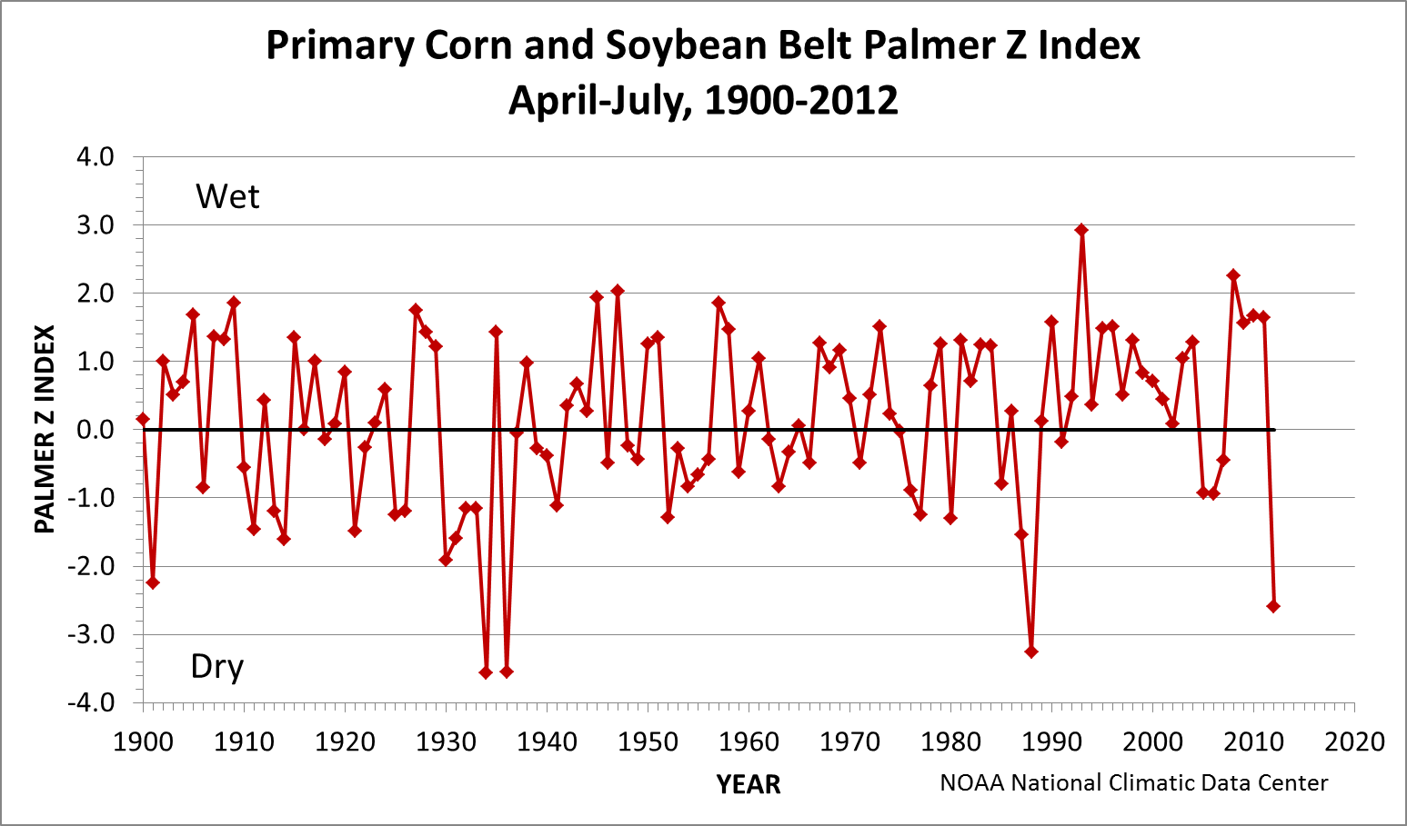
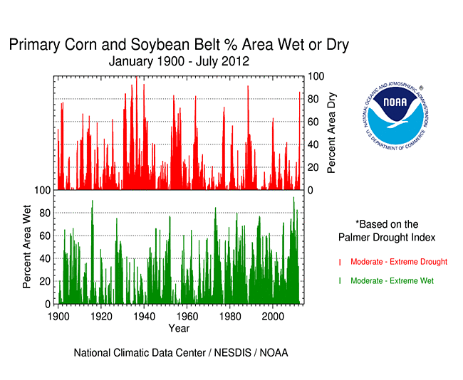
The Primary Corn and Soybean agricultural belt has been especially hard hit by drought the last four months. This region, collectively, has experienced the second warmest and sixth driest April-July in 2012, resulting in the fourth most severe Palmer Z Index (behind 1934, 1936, and 1988). The extreme severity of the dryness and evapotranspiration demand over the last four months resulted in a rapid increase in the percent area of this agricultural belt experiencing moderate to extreme drought (as defined by the Palmer Drought Index) and moderate to exceptional drought (for the Midwest and High Plains as defined by the USDM). By the end of July 2012, about 86 percent of the Primary Corn and Soybean Belt was experiencing moderate to extreme drought (based on the Palmer Drought Index), surpassing all previous droughts except those in 1988 and the 1930s.
Western U.S.
Showers and thunderstorms from the summer monsoon brought above-normal rainfall across parts of the Southwest this month, and Pacific frontal systems dumped above-normal precipitation in the Pacific Northwest. The areas in between experienced short-term drought during July. The rain that did fall brought relief to some areas and lowered the percent area in drought a few percentage points, but it was not enough to end drought in the West. Drier-than-normal weather has dominated from the Southwest and intermountain basin to the Central and Southern Rockies for the water year to date (October-present), as reflected in low elevation as well as high elevation (SNOTEL) precipitation, especially for the southern half of the West. Reservoir storage was below average statewide in most of the western states. Hot, dry, windy weather contributed to many wildfires across the West. According to the USDM, 68 percent of the West was experiencing moderate to exceptional drought at the end of July, a 4 percent increase compared to June. The Palmer Drought Index percent area statistic was about 53 percent, reflecting a remarkable rise over the last seven months.
 |
 |
Historical Analogs
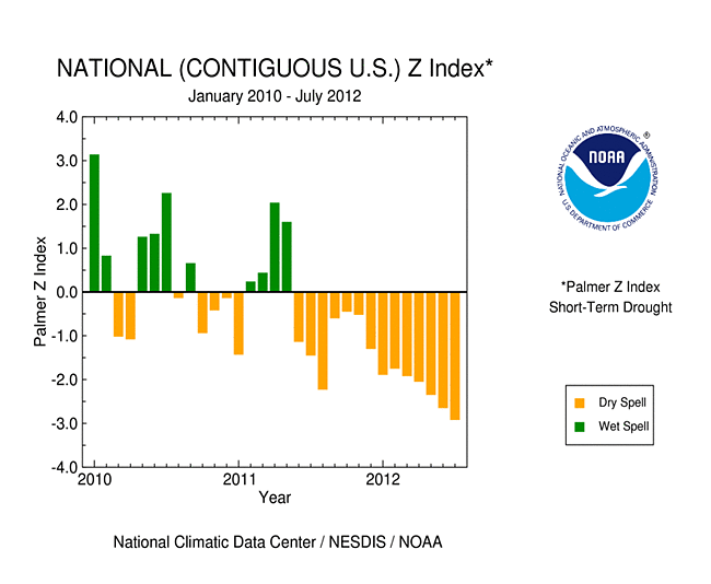
The persistent warmth and dryness of the last couple years have been so severe that the nationally-integrated Palmer Z Index has been consistently negative (water demand outstripping water supply) for the last 14 consecutive months. This is largely behind the rapid expansion of drought this year which has led to the largest percent area in moderate to exceptional drought in the 13-year USDM record and largest moderate to extreme drought area (based on the Palmer Drought Index) since the 1950s. In 2012, about 57 percent of the contiguous U.S. was in moderate to extreme drought at the end of July. The last time drought was this extensive was in December 1956 when about 58 percent of the contiguous U.S. was in moderate to extreme drought.
Even though the 2012 drought has reached a spatial extent that rivals the maximum extent of the 1950s drought, every drought is different. Historical analogs to the current drought can be determined by comparing the spatial pattern and intensity of various climate indicators using statistical tools such as the correlation coefficient and mean absolute difference. When applied to the temperature pattern for July 2012, several Julys from the 1930s (1934, 1935, 1936) are a close match in many regions. July 1936 matches July 2012 fairly well for precipitation, and July 1954 matches July 2012 reasonably well for PDSI and PHDI (although there are other months from other years that match July 2012 for all of these climate indicators). When looking at the seasons from January-July through June-July collectively, the 1950s are the closest match for the Palmer indices (PDSI and PHDI) in 2012, and the 1950s and 1988 closely match the 2012 Palmer Z Index, but there is less consistency for temperature and precipitation.
|
The 2012 drought is the latest of a series of episodes which have covered a larger-than-average area of the nation beginning in the late 1990s. If the criteria for determining when this nationally-significant drought period started is ten percent or more of the country persistently in moderate to extreme drought, then the current period started around Spring 1999. The spatial extent of drought has waxed and waned from 1999 to 2012. Again, if ten percent is used as a criteria, then the 1999-2012 drought period has had three episodes, roughly 1999-2004, 2005-2009, and 2010-2012. During this time, ten percent or more of the country experienced moderate to extreme drought for a total of 140 months. |
 |
|
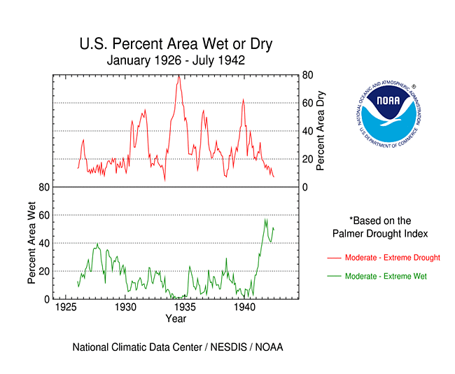
Using the ten percent criteria, the 1930s droughts started around May 1929 and ended in February 1942. Some part of the country experienced drought during the 1929-1942 period. Like the 2000s drought, the spatial extent of the 1930s drought waxed and waned. Again, if ten percent is used as a criteria, then the 1930s drought had three episodes, roughly 1929 to early 1933, mid-1933 to early 1938, and late 1938 to early 1942. During this time, ten percent or more of the country experienced moderate to extreme drought for a total of 148 months. |
|
For the 1950s droughts, the ten percent criteria indicates the nationally-significant drought started around August 1950 and ended in September 1957. Some part of the country experienced drought during the 1950-1957 period. Unlike the 1930s and 2000s droughts, the spatial extent of the 1950s drought essentially expanded and stayed at a relatively large area for most of the drought episode (especially from late 1953 to early 1957). Again, if ten percent is used as a criteria, then the 1950s drought had essentially one episode. During this time, ten percent or more of the country experienced moderate to extreme drought for a total of 86 months. But the average monthly area was 36 percent, compared to 32 percent for the 1930s drought and 29 percent for the 2000s drought. |
 |
Pacific Islands: According to reports from National Weather Service offices, the Pacific ENSO Applications Climate Center (PEAC), and partners, conditions varied across the Pacific Islands.
Drought conditions and impacts are summarized by the National Weather Service office in Honolulu. SPI values are provided below.

On other Pacific Islands (maps — Micronesia, Marshall Islands, basinwide), July was drier than normal for Majuro, but near to above normal for the rest of the stations. Majuro has been drier than normal for the last three months. Total rainfall for the last 12 months (August 2011-July 2012) was near to above normal for all stations.
| Station Name** | Aug 2011 | Sep 2011 | Oct 2011 | Nov 2011 | Dec 2011 | Jan 2012 | Feb 2011 | Mar 2012 | Apr 2012 | May 2012 | Jun 2012 | Jul 2012 | Aug 2011-Jul 2012 |
| Chuuk | 144% | 118% | 97% | 136% | 125% | 57% | 181% | 107% | 40% | 173% | 131% | 145% | 120% |
| Guam IAP | 102% | 129% | 135% | 83% | 103% | 162% | 94% | 215% | 121% | 224% | 107% | 109% | 122% |
| Kapingamarangi | 162% | 107% | 57% | 81% | 124% | 109% | 71% | 121% | 102% | 143% | 179% | 150% | 121% |
| Koror | 155% | 266% | 122% | 62% | 97% | 36% | 126% | 121% | 120% | 122% | 95% | 94% | 117% |
| Kosrae | 122% | 104% | 154% | 95% | 174% | 65% | 185% | 60% | 84% | 86% | 99% | 127% | 110% |
| Kwajalein | 144% | 111% | 125% | 130% | 84% | 134% | 114% | 84% | 68% | 161% | 117% | 171% | 124% |
| Majuro | 108% | 115% | 115% | 119% | 91% | 107% | 65% | 194% | 97% | 59% | 81% | 68% | 100% |
| Pago Pago | 72% | 29% | 137% | 157% | 75% | 61% | 98% | 131% | 90% | 126% | 115% | 110% | 101% |
| Pohnpei | 138% | 115% | 77% | 123% | 110% | 82% | 138% | 98% | 45% | 115% | 100% | 96% | 101% |
| Saipan | 93% | 68% | 140% | 57% | 110% | 77% | 183% | 35% | 33% | 166% | 118% | 190% | 104% |
| Yap | 129% | 156% | 101% | 112% | 116% | 33% | 117% | 185% | 89% | 142% | 99% | 106% | 116% |
** Clicking on the station name will reveal a climatology graph of the normal monthly rainfall.

[top]
State/Regional/National Moisture Status
A detailed review of drought and moisture conditions is available for all contiguous U.S. states, the nine standard regions, and the nation (contiguous U.S.):
| northeast u. s. | east north central u. s. | central u. s. |
| southeast u. s. | west north central u. s. | south u. s. |
| southwest u. s. | northwest u. s. | west u. s. |
| Contiguous United States |
[top]
Drought Indicators
- Palmer Drought Indices
- Standardized Precipitation Index
- long-term (36 to 60 month) percent of normal precipitation maps
- airport station percent of normal precipitation maps
- statewide precipitation rank maps
- Cooperative station percent of normal precipitation maps
- percent of average maps for the SNOTEL stations in the western mountains provided by the Western Regional Climate Center
- hydrologic year precipitation
- snow water equivalent of snowpack
- satellite-based observations of vegetative health
- National Weather Service model calculations of soil moisture, runoff, and evaporation
- National Weather Service model calculations of soil moisture using the Leaky Bucket Model
- Midwest Regional Climate Center model calculations of soil moisture
- topsoil moisture conditions observed by the USDA and mapped by the Climate Prediction Center
- pasture and range land conditions observed by the USDA and mapped by the Climate Prediction Center
- streamflow maps maintained by the USGS
[top]
Contacts & Questions
 NOAA's National Centers for Environmental Information